NBAcentel
Member
Massive improvement over the prior run. Far more wintry east of the apps. Lots of IP/ZR showing up 

Also improvement across the western SE
Also improvement across the western SE
Any decent hits for us back west?Looks like the EPS is gonna be a big improvement for wedge areas. Also some big ice storms on certain members again
This definitely has been a trend on the EPS the last few runs.Massive improvement over the prior run. Far more wintry east of the apps. Lots of IP/ZR showing up View attachment 141174View attachment 141175
Also improvement across the western SE View attachment 141178
Things look solid for at least some snow. Still too early to say it’s worth driving here for though.I’m thinking of driving up from Birmingham with the kids Sunday afternoon since they’re out of school Monday and I’m off work. Do you think staying somewhere around Nashville would be good, @olhausen? Thanks!!
Massive improvement over the prior run. Far more wintry east of the apps. Lots of IP/ZR showing up View attachment 141174View attachment 141175
Also improvement across the western SE View attachment 141178
Can you go further west please?
I noticed that same thing...there was a lot more "noise"/lower height arguing btwn the members with that area over BC. 00z run had a lot more higher heights...WE ALL need that to be true and drop that down the west coast and let it tumble deep SE and that could be the caboose if you will before Canada gets flooded with pac air again.
More of a s/w further west if I can actually maintain its self.


For the guy responding with a question mark, this isn't a simple run to run trend comment, this is a comment about runs over the past three days and is a longer trend of much less QPF, especially across TN, MS, and AL, and far N GA.Not a great trend generally for most on the SE.
View attachment 141185
Yeah seems to be consolidating toward more of a KY,WV/VA event.For the guy responding with a question mark, this isn't a simple run to run trend comment, this is a comment about runs over the past three days and is a longer trend of much less QPF, especially across TN, MS, and AL, and far N GA.
Could be wrong here but looks like the Canadian has been increasing totals with each recent runs. Around Memphis anyways.For the guy responding with a question mark, this isn't a simple run to run trend comment, this is a comment about runs over the past three days and is a longer trend of much less QPF, especially across TN, MS, and AL, and far N GA.
Yes, but…Feeling like this one might be legit here. And it's gonna be 11 degrees gonna stick to everything and ratios will probably be higher than the mapsView attachment 141187

Need that thing to have more buckle.


I always hold out hope that sleet can save me from a true freezing rain Ice storm. Over half the members have something wintery. Best chance so far, especially with the cold temperatures afterwards for some staying power that will make any storm more impactful.That’s a lot of ice storm members. Sheesh View attachment 141196View attachment 141197

Do you have a shot of the 138hr west in the deep southThat’s a lot of ice storm members. Sheesh View attachment 141196View attachment 141197
its still going to be cold but not as cold as modeled with no snow on the groundStorm is gone, cold is slowed, probably have a full southeast ridge Tuesday.
Guess I’m going to hold out hope until Friday mid-day runs. The cold is there we just need the moisture.people in the midsouth is losing this one quickly. gfs is pretty dry
unfortunatley living in the south its just hard having both the same timeGuess I’m going to hold out hope until Friday mid-day runs. The cold is there we just need the moisture.


I have a feeling that more GEFS members are going to be showing a CAD set up this run.This is a just a few adjustments away from something big View attachment 141226View attachment 141227
think we will do better than that but hey still bout an inch especially for ypuunfortunatley living in the south its just hard having both the same time
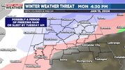
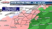
 ICE NEXT WEEK? Lots of questions about the First Alert Weather Day we declared for next week regarding possible winter mischief. Both GFS/Euro guidance shows a shallow layer of frigid arctic air settling in on Monday. As this happens, moisture will start overrunning the state, as a low pressure system takes shape over the Gulf. This could bring a period of winter precipitation and the types would primarily be freezing rain or sleet. There are some big differences in data regarding timing and amount of precipitation. The highly reliable ensemble data keeps the heaviest precipitation south. I wouldn’t cancel any big plans until we get a better handle on the amount of precipitation and timing. However, know we could have impacts and it’s one of the reasons why we’ve declared another First Alert Weather day.