NWMSGuy
Member

I have what I’m sure is a stupid question but I keep hearing west of the mountains and east of the mountains. I’m in Atlanta. Where do we fall? I feel like it always snows west or east of us.Think the biggest problem with this setup is the initial Cutter not escaping east to Atlantic Canada but rather towards Hudson Bay, if this was to exit or at least a big piece of it was able to exit towards Atlantic Canada, you could slow down the pattern even more and amplify the upstream pattern, along with confluence, and a better cold feed. But instead we get a messier, frontal look, because the progression of the cutter isn’t favorable. It could work out west of the mountains, but east we would need a trailing northern steam wave that digs favorably after the Arctic front moves through View attachment 141091
Neither really, the continental divide runs right down peachtree street. We can benefit from cold from either direction, our issue is we are the furthest from the source of both directions. If it’s a CAD fueled storm, we are the last in line. If it’s cold funneled from the northwest, we are also the last in line. The only benefit we have, specifically northwest burbs is the fact that we can get some northwest flow flurries or snowshowers with some elevation increase. The east side of the metro is 600-800’ while the northwest is 900-1200’, which makes a huge difference when your temps are always marginal.I have what I’m sure is a stupid question but I keep hearing west of the mountains and east of the mountains. I’m in Atlanta. Where do we fall? I feel like it always snows west or east of us.
Well the Icon finally brought the cold air east after holding back every run.Less push into Texas, a little flatter, but is trying mightily to expand eastward! Changes are not done on this one. At. All.


It develops a gulf low, throws moisture back to the NW, but the cold is not far enough east to catch it...like Bob Uecker would say, "just a bit outside" as the pitch sails 30 feet behind the batter.Well the Icon finally brought the cold air east after holding back every run.
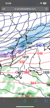
looking like a good 1-2 inch storm for all of us. Luckily we will have good rates in those cold tempsNorth Alabama is back. ??View attachment 141124
Given the cold during and after, even an inch of snow, and in all likelihood, ice, and sleet before, the impacts will be substantial and long-lasting.looking like a good 1-2 inch storm for all of us. Luckily we will have good rates in those cold temps


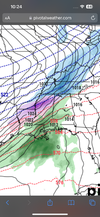
It's a clear outlier tho.I think this is pretty concerning. The UKMET goes full on western trough and gets the southeast ridge going View attachment 141130View attachment 141131
Remember when the icon and UK was the outlier models in February 2021…It's a clear outlier tho.
Yes, it is very concerning. It's not moving east, either. Upper level winds are running due west to east from CA to MD at 120 hours and it's about the same at 144 hours with a slight dip over Nevada. Very weird.I think this is pretty concerning. The UKMET goes full on western trough and gets the southeast ridge going View attachment 141130View attachment 141131
Ol' Ukie coming in to ruin the mood!I think this is pretty concerning. The UKMET goes full on western trough and gets the southeast ridge going View attachment 141130View attachment 141131
Honestly I’d root for this because maybe it shakes things up in a better way 4-5 days later. Not good for western SE though with the initial threat.I think this is pretty concerning. The UKMET goes full on western trough and gets the southeast ridge going View attachment 141130View attachment 141131
I agree, def...and outlier at the moment, but let's see if any other models try to show that as well. It could be in la la land or starting to see something different..Remember when the icon and UK was the outlier models in February 2021…
Sure, it could be onto something. If the Euro moves in that direction, which it often does, then it would be more concerning to me. Otherwise, as I and others have pointed out, the models are all struggling with the mid-range and the Ukie is just another solution.Remember when the icon and UK was the outlier models in February 2021…
Wonder if will need to wait for this energy to come ashore before we know how this really plays out?Sure, it could be onto something. If the Euro moves in that direction, which it often does, then it would be more concerning to me. Otherwise, as I and others have pointed out, the models are all struggling with the mid-range and the Ukie is just another solution.
Looks like the 0z EUROEastward ho.
I think it's mainly driven by the orientation of the Alaskan and NW Canada ridge. Just intuitive as I haven't had a chance to look closely.if will need to wait for this energy to come ashore before we know how this really plays out?
Mjo mjo mjoRemember when the icon and UK was the outlier models in February 2021…
Needs to continue trending even further south and east.