L
Logan Is An Idiot 02
Guest
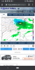
While this looks similar to the 06z run. The axis of the bigger snow totals shifted south a pretty good bitGeeeez GEFS
While this looks similar to the 06z run. The axis of the bigger snow totals shifted south a pretty good bitGeeeez GEFS
Lol autocorrect thinks para should be parade.
This is absolutely nuts, wtf is going on!!
Yeah, it’s really difficult to have any faith in the GFS when we’re in the NAM’s range now.As much as I want the GFS/GEFS to be right because it’s good for MBY, I’m with the NAM.
It did a really good job with predicting the dry slot for the front end stuff. I think it was a little too dry with the back-end snow though.Maybe wishcasting here, but with our last event the NAM also had very little precip up until about 36 hrs, then started beefing it up. Let’s see how it trends
To be fair the Rgem matches the gfs with qpf but it’s just a lot warmer.
Looks like gfs family and rgem vs the rest.
Bingo. Happend several other times. But todays 12z is where its strung the energy out some.Maybe wishcasting here, but with our last event the NAM also had very little precip up until about 36 hrs, then started beefing it up. Let’s see how it trends


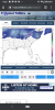
Agreed. I'd love to jump on the gfs but until something really backs it up this seems much more realisticThe NBM looks very very realistic here View attachment 68096
Agreed. I'd love to jump on the gfs but until something really backs it up this seems much more realistic
So this begs the question.........we had good runs a week ago for this timeframe with some decent amounts......wouldnt call them big dogs but solid 6 inch members on the ensembles and op runs.
Is this a situation like we've seen before where the models lose the system in the mid range only to bring it back at crunch time in the short range? The last 72 hour of trends have all been improving just not to the degree of the Gfs.
Haven’t seen it yet, so guessing the UK isn't so hot....or maybe it's too hot?

This has gotta be a Kuchera ratio right? We won't get even half of this lol
Not it's not at all loHaven’t seen it yet, so guessing the UK isn't so hot....or maybe it's too hot?

That is the 10:1 ratio not Kuchera, I posted the Kuchera further down, it was less but still significantThis has gotta be a Kuchera ratio right? We won't get even half of this lol


The amount of hits on the gefs compared to the last one is insane.
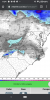
View attachment 68104
100 % (okay 99.9 I see u.. you ugly #15) show a NC snow storm in 48 hours ... some even sho.w a FOOT
we can’t blow a 48 hour lead?? RIGHT?!?
This will go down in the history books for the forum .. and will give us lots of answers on who we need to listen to going forward
View attachment 68104
100 % (okay 99.9 I see u.. you ugly #15) show a NC snow storm in 48 hours ... some even show a FOOT
we can’t blow a 48 hour lead?? RIGHT?!?
This will go down in the history books for the forum .. and will give us lots of answers on who we need to listen to going forward
To be fair the NAM screwed us last year. Predicted 6 + and we got maybe 2"Not it's not at all lo
Eric hates the nam. I remember getting into an argument with him about it ?


Lol we can and have before.View attachment 68104
100 % (okay 99.9 I see u.. you ugly #15) show a NC snow storm in 48 hours ... some even show a FOOT
we can’t blow a 48 hour lead?? RIGHT?!?
This will go down in the history books for the forum .. and will give us lots of answers on who we need to listen to going forward
January 2017WRONG, lol. I've blown a 12 hour lead of 6+ inch means on both the GEFS and EPS for MBY. Ended up with less than an inch. Has happened more than once.