NBAcentel
Member
Hot diggity damn 


 Crazy part is AI could be better with the tilt but it works regardless. Beautiful run man
having a "conservative" reputation is preferable to having a "boys cries wolf" reputation. everyone here rags on brad p - idk why. he's a savvy vet that knows not to fan the flames on facebook unless a signal is ironcladAs stated before, a lot of Mets in the area have been/felt roasted for buying in to 200+ hour models and are very conservative on agreeing with anything this far out! Some say they will only call for snow once it’s falling!
some of yall are really smart and could go toe to toe with many, if not most mets in winter storm forecastingA while back, he engaged with some southern weather hobbyist around a CAD event and was schooled by the hobbyist. He quit that practice immediately as he was dead wrong. Some guys here have forgotten more about CAD than he will ever know.
He's a pattern guesser.
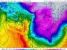
More tilt means more warm nose.View attachment 157254View attachment 157255View attachment 157256Crazy part is AI could be better with the tilt but it works regardless. Beautiful run man


 AI tried to go for another one lol weenie fuel, but verbatim that’s snow in FL/SGA
View attachment 157254View attachment 157255View attachment 157256Crazy part is AI could be better with the tilt but it works regardless. Beautiful run man
Ok snow in florida might be a little crazyView attachment 157260View attachment 157261View attachment 157262AI tried to go for another one lol weenie fuel
View attachment 157260View attachment 157261View attachment 157262AI tried to go for another one lol weenie fuel, but verbatim that’s snow in FL/SGA

 AI just showed us this look twice in a run. We barely get these looks in winter anymore normally
Typically yes but not when you have this much arctic air sitting on top of you. 0C 850’s down deep in the gulf, you can afford more tilt.More tilt means more warm nose.
Yep..some of us tried to tell him but he thought he knew it all. I don't want to trash him too much as that was quite some time ago and people change but the Dude was arrogant as hell.A while back, he engaged with some southern weather hobbyist around a CAD event and was schooled by the hobbyist. He quit that practice immediately as he was dead wrong. Some guys here have forgotten more about CAD than he will ever know.
He's a pattern guesser.
The Euro AI has had some ups and downs so far this winter, but it was the first to really latch on to the -NAO idea.AI loading up a pants nuker
I'll keep this one but anymore about this in this thread will be deleted, please move this discussion to banter please. Thank youYep..some of us tried to tell him but he thought he knew it all. I don't want to trash him too much as that was quite some time ago and people change but the Dude was arrogant as hell.
Its one thing to get 1...another to get 2 days apart but add in crazy cold....its the stuff the things dreams are made of. Not much to add as many have already expressed the exact same opinion as I've thought and it's way into fantasy range but man it's hard not to be unusually optimistic given the time range. To maybe add something, you know you are doing well in the cold department when there is no upper savannah river/lee side screw zone is even being hinted at. Would be real lovely if we can get these inside at least a week to 5 days though so it isn't totally crazy to try and get into some details without making yourself look like a total weenie.So we will do a 2/12/2010 and a 1/28/14 within a few days, cool.
No problem...probably should have bit my tongue anyway. Apologies.I'll keep this one but anymore about this in this thread will be deleted, please move this discussion to banter please. Thank you
 ️
️Imho, nearly everything this winter has been going to plan from a long range perspective.
Now the question is does this pattern persist past mid-month? Even if it doesn’t, if we put a lot of snow down the next couple weeks, we got a shot to keep the gravy train rolling a little longer. These kinds of patterns tend to feed back on themselves

Still think we gonna be ok. Probably be several different looks next coming days.big difference here on the 00z GFS. Let’s see what this does View attachment 157308
i meant it by it looks better for sureStill think we gonna be ok. Probably be several different looks next coming days.
Yep, I remember it well. As a matter of fact, I might have been in that conversation concerning CAD in NC.A while back, he engaged with some southern weather hobbyist around a CAD event and was schooled by the hobbyist. He quit that practice immediately as he was dead wrong. Some guys here have forgotten more about CAD than he will ever know.
He's a pattern guesser.
You can just see the huge cold shot coming from that image and that isn’t far off.big difference here on the 00z GFS. Let’s see what this does View attachment 157308
Greenland block is even stronger, and no ridging before the next energyi meant it by it looks better for sure


RetreatOdd look. Building CAD or retreating CAD there?
Think it's still early, but anyway, the CMC seems happy about the patternThis run is not looking near as cold as 18z but I doubt anyone expected it to.