Loganville Winter
Member
And probably a flood watch or warning as well?In the last three days ive been under a Tornado warning, tornado watch and a winter weather advisory
And probably a flood watch or warning as well?In the last three days ive been under a Tornado warning, tornado watch and a winter weather advisory
Friday I had a flood warning and also a wind advisory today.And probably a flood watch or warning as well?
What? Isn't he below 85? My impression was upstate wouldn't see anything. This is one confusing Storm. ULLs has mind's of their on.@Jimmy Hypocracy ! You are golden!


Yeah that backside band would be a reason why my map busts low, very impressiveThe slightest of southward shifts all day, just a little more would do a world of good for NC peeps
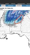
View attachment 101255

Not looking like it. Still 36 with back edge of precip already approaching. This has got dud written all over it for hereNorthern miss gonna get some nice totals
Sent from my iPhone using Tapatalk
Not looking like it. Still 36 with back edge of precip already approaching. This has got dud written all over it for here
Seems to happen every time where the backend of precip is faster then modeledYeah I mean I'm a casual observer here but I don't like how fast the precip is clearing out. Y'all need all the help y'all can get with everything else borderline
Seems to happen every time where the backend of precip is faster then modeled
Many of us in central NC are right on the line of seeing something nice (>1") or very little to none. Shifts of 20 miles are huge at this point. I would take that outcome and run.The slightest of southward shifts all day, just a little more would do a world of good for NC peeps
View attachment 101255
I was surprised the RGEM didn’t tick south. Definitely gives me pause. I’m just hoping to see a nice burst of flakes in the air. Looks like you should get at least an inch on the ground? What are you thinking for your area?The slightest of southward shifts all day, just a little more would do a world of good for NC peeps
View attachment 101255
2 more twenty mile shift south and we might really be cookingMany of us in central NC are right on the line of seeing something nice (>1") or very little to none. Shifts of 20 miles are huge at this point. I would take that outcome and run.
does he give accumulations for north alabama?JB (Robert) has spoken! Sorry JimmyView attachment 101253
Just another 50 miles south and I will be happy to cash in here in Raleigh. GFS is now aligning with most other models, however.


Should help also we are past peak heating of the day. The snow really should start expanding east in next hour or so.Lots of blue starting to show on the back side of the precip . Cold air really diving SE now as H5 digs
Sent from my iPhone using Tapatalk
A noticeable more northward component to the moisture fetch as wellLots of blue starting to show on the back side of the precip . Cold air really diving SE now as H5 digs
Sent from my iPhone using Tapatalk
Daytime heating doesn’t matter. The 500mb low is all that matters. Needs to fly east.Should help also we are past peak heating of the day. The snow really should start expanding east in next hour or so.
")
Yep. Here we go…Lots of blue starting to show on the back side of the precip . Cold air really diving SE now as H5 digs
Sent from my iPhone using Tapatalk

Think that's gonna slow the backside or even pivot it?Lots of blue starting to show on the back side of the precip . Cold air really diving SE now as H5 digs
Sent from my iPhone using Tapatalk

Boo this man!Gut feeling says those in the red need to be prepared for disappointment.
Unless it shifts south another 50 miles, I'll see some light snow as the dying deform band rolls through. To close to the low and then that dry slot are problematic but we shall see. I think you out perform me with this oneI was surprised the RGEM didn’t tick south. Definitely gives me pause. I’m just hoping to see a nice burst of flakes in the air. Looks like you should get at least an inch on the ground? What are you thinking for your area?
Thanks ?Gut feeling says those in the red need to be prepared for disappointment.
Usually the screw zoneGut feeling says those in the red need to be prepared for disappointment.
December 2017 would like a wordUsually the screw zone