The Euro/EPS will likely come NW but it's not going to flop back & forth like other guidance. It's the more mature super adult model out of all of them. If it's going to come NW, it's going to be in small ticks not bounce around 100s of miles inside 100 hours.Question is: is this a trend to the drier EURO or is this a windshield wiper effect and we trend to dry and then we shift back NW within 36 hours like normal? Starting to remind me of a warmer event from last year based on that ensemble footprint
-
Hello, please take a minute to check out our awesome content, contributed by the wonderful members of our community. We hope you'll add your own thoughts and opinions by making a free account!
You are using an out of date browser. It may not display this or other websites correctly.
You should upgrade or use an alternative browser.
You should upgrade or use an alternative browser.
Jan. 17-18, 2026 SE Winter Weather Threat
- Thread starter RBR71
- Start date
I'm curios as to why models think there won't be as much overruning. Wasn't the airmass drier last year?
I think we’ll start to see it start by 00z tonight.
Warmer trend overall seen on the GEFS. 
I would caution anyone cola east to not throw in the towel just bc western posters are cliff diving. This still is a pretty solid setup for snow for eastern Carolina’s.
If the GFS/NAM-adjacent precip scenario does not unfold I would 100% be sweating temperatures in the eastern piedmont/coastal plain
UKMet

accu35
Member
UK is NW
GeorgiaGirl
Member
Ukie precip is fine for many areas.
But temps temps temps.
Just looking briefly, two spots in Georgia are like 5 degrees warmer than the GFS run that worked and put down a couple inches of snow.
But temps temps temps.
Just looking briefly, two spots in Georgia are like 5 degrees warmer than the GFS run that worked and put down a couple inches of snow.
Bigedd09
Member
I think that’s a great look for 3 days out
Sent from my iPhone using Tapatalk
UK has precip NW of previous runs... but also much warmer than previous runs. It basically keeps precip *only* on the "non-freezing" side of the temperature gradient -- and then pushes that gradient NW.
Brandon10
Member
UKMET track is perfect for eastern nc snow..temperatures not.

fwiw i did think we would endure a pain cycle or two. we always do. we saw modest improvements at this stage last year with our storms and i think we will see that again. as a reminder i endured a few euro and euro ensemble blanks at this range last year in richmond for storms that gave me warning criteria snowfall. they're good but i do think they can get too dry
ducketta27
Member
If the Euro holds its cold… still in business for most of the board. If the Euro starts the NW trend now (therefore warmer)… most of the board not going to score
Sent from my iPhone using Tapatalk
Sent from my iPhone using Tapatalk
What does budget cuts have to do with the current GFS performance? It's been spitting out crap since it was the AVN model. It's the programmers who have programed it and continuously update it. Not the Ben Franklins. Thing has been paid for. Gets same data points ingested as everything else.Pretty much all of the GEFS ensembles look like they try, although some of them might be light. With this being about 3 days out, will be a pretty big fail if it's whiffing completely and yes, will make me wonder about those budget cuts...
The 6z AIFS-Ens and WeatherNext2 — the best models in the world — both have similar forecasts: no big snow event anywhere in this board. 

I'd imagine those warmer temps on the North & West fringes are due to lack of precip.
Earlier the models had those places N of 85 wet bulbing down to around freezing,
Give or take a few degrees.
If the models sense there's no precip,
Then they'll stop the diabetic process of lowering those temps.
Unfortunately those of us in the foothills of the Carolinas seem to be in the ultimate screw zone the last 5-7 years.
If this ends up being a storm that hits the Central or Eastern Carolinas it'll be a huge kick in the gonads.
I hope we all get something but if we aren't I pray that those South & East of me get something.
Mahomeless
Member
- Joined
- Oct 17, 2023
- Messages
- 900
- Reaction score
- 2,158
That is probably the least likely area for snow in all of this due to BL issues.I would caution anyone cola east to not throw in the towel just bc western posters are cliff diving. This still is a pretty solid setup for snow for eastern Carolina’s.
Seems like he is going towards the lack of precip now, by no means am I speaking for him but the trends don’t lie, we have been moisture starved for the longest time! I’m not giving up but I’m going towards par!I'm going off of the analysis that Webber has provided over the past twenty four hours about how these setups transpire over in the Carolinas..
Also, idk if taking the GRAF at day 3 as gospel is the right idea but that's just me
I'm worried about the cold air feed for this storm too. It's deja vu all over again when it comes to the rain/snow line setting up shop over Wake County. This old timer has seen so many storms where this is the case.A little worried about the lack of Northerly wind intensity and colder temps as this system arrives in the Carolina’s. Looks like the mix line will set up right around wake county again with a steep gradient!
Webberweather53
Meteorologist
The 6z AIFS-Ens and WeatherNext2 — the best models in the world — both have similar forecasts: no big snow event anywhere in this board. View attachment 183781View attachment 183782
Nowhere near as suppressed as the GRAF, just too dang warm
bncho
Member
I'm starting to think it might be hard to get accumulating snow for most of y'all east of the Appalachians, unless you're in VA.
HailCore
Member
Latest Euro AI looks to have shifted everything a bit west, including precip and unfortunately cold temperatures
a not insignifcant NW shift from the EC AIFS


Blue_Ridge_Escarpment
Member
Good to see from the world class model
Let it begin. Big jump there
All hail the KING CZAR model
Cad Wedge NC
Member
That's a pretty big jump NW....
packfan98
Moderator
For sure. Seems like models are converging. Too bad the boundary layer isn't colder.
Don't get too excited:

But like I said a few days ago, the EC AI 2m's run too warm at night usually. Tends to be 2-5F
But like I said a few days ago, the EC AI 2m's run too warm at night usually. Tends to be 2-5F
its predominantly rain either wayBut the AIFS is superior and never makes jumps guys
What is pretty funny when you think about it, if you were a pro met 30 years ago making a 3 day forecast for this exact scenario, your forecast would look just almost identical to a forecast from a pro met today making the same forecast.
As modeled yes, but if 2m's are a bit warm like usual, that can make a difference in a dynamic cooling scenarioits predominantly rain either way
HailCore
Member
The cooler temperatures always look kind of smoothed out like an ensemble which usually makes them a bit warmer.Don't get too excited:
View attachment 183787
But like I said a few days ago, the EC AI 2m's run too warm at night usually. Tends to be 2-5F
rburrel2
Member
The AI models were right, but that doesn't mean a stronger than modeled fronto band won't streak across the northern edge of lift at go time and drop .2-.3 of liquid. We've seen it happen numerous times in the past... and not show up on modeling until it's developing on radar in real time.
I'm not saying it'll happen, but i'm saying it can still happen.
I'm not saying it'll happen, but i'm saying it can still happen.
Precip moved west 50-100 miles either wayits predominantly rain either way
I was able to find an old NAM trend gif from a few days before the December 2017 snow. Not an exact carbon copy for sure, but there are some similarities with this upcoming system. Ours isn't digging quite as much into Mexico to this point

Current set up

Current set up
Webberweather53
Meteorologist
Not too surprised.
The tried and true philosophy of leaning towards a given solution based on actual dynamics at play (warm advection aloft, isentropic upglide, etc.) almost always trumps the idea of favoring a solution because one set of models is bad and others are “good”
It's cold enough aloft even to CAE, but the surface temps go up with the NW shift of the moisture... so yeh. 


packfan98
Moderator
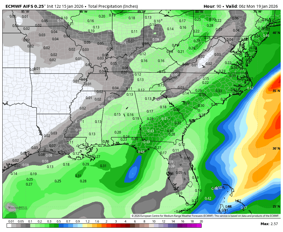
Early Euro frames look to be juiced up too. We need the precip, regardless of type.
MichaelJ
Member
I think this will end up east of the GFS and slightly west of the EURO. However, the temps will prevent any significant snow in the East and even folks east of I-77 will likely be too warm and moisture starved. A cold drizzle is pretty much what I expect here in the Triad POSSIBLY ending as some light wet snow showers. While miracles do happen, I don't go around betting on one