It would help, although a classic storm for a boardwide storm really involves the surface low staying just offshore in the Gulf and crossing over the FL panhandle (near JAX), then swinging up NE in the Gulf Stream 100-200 miles off the Atlantic Coast. The JMA is a little north of that.If that low hugs the gulf coast does that put a lot more of us in the frozen precip with this setup?
-
Hello, please take a minute to check out our awesome content, contributed by the wonderful members of our community. We hope you'll add your own thoughts and opinions by making a free account!
You are using an out of date browser. It may not display this or other websites correctly.
You should upgrade or use an alternative browser.
You should upgrade or use an alternative browser.
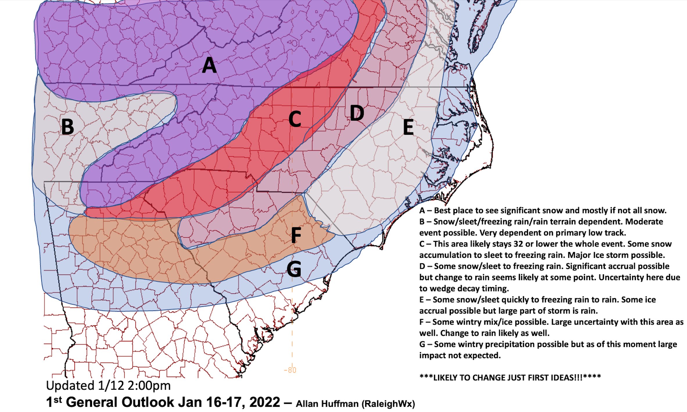
Wintry Jan 15-16 Winter Storm Discussion & Obs
- Thread starter SD
- Start date
I saw someone post it in the Whamby thread earlier. I need to reup my model subscriptions so I can look at it myself.BTW, do ya have the Korean?
Probably seeing more of that front end thump than other models before the ice storm. Assuming the NAMS will be able to hone in on this stuff soonSlight as it may be I'll take any improvement where I can get it lol


tennessee storm
Member
What’s that off of accu? Twc curiousAt least there seeing that Low Far East
NBAcentel
Member
I’m willing to bet the NAM isn’t gonna show much FGEN snow, but the hrrr will sniff it out
Transfer will occur along the mid level thermal gradient, right now that looks through the Carolinas with primary surface starting to crank near Florence and then up the coastal plain into the Mid Atlantic.
iGRXY
Member

Updated my thinking for the system so far. Nothing really different from what we've seen on the modeling so far. Probably will update this tomorrow after 12z if anything has trended better or worse and put out a first call map on Friday after 12z.
iGRXY
Member
Was reading the GSP discussion from 12:45 and they are pushing for the idea of more snow especially along 85. Thinking is it will be a bit colder than models are hinting at.
As of 320 am EST Wednesday: The latest guidance suite is starting to
feature a bit better agreement on the overall aspects of the winter
storm likely to impact the area over the weekend. However, there
remains some variation regarding low tracks, thermal profiles, and
QPF for various periods, and these details continue to make
precipitation types and amounts highly uncertain.
Nearly all solutions have trended toward cutting off the southern
portion of the split upper flow near the lower Mississippi River
Valley by late Saturday. In a slight role reversal over the past 24
hours, the ECMWF 500 mb prognostic now features a cutoff low with a
farther south low center position than the operational GFS. However,
both models agree fairly well on the general timing, migrating the
system over the Deep/Mid South Sunday and then over the Carolinas
Sunday night as the system phases back into the northern stream.
Meanwhile, sprawling surface high pressure from southern Ontario to
New England will establish a strong cold air damming configuration
east of the Appalachians ahead of the storm on Saturday. The
resulting surface-based cold layer is becoming one of the more
confident aspects of the upcoming weekend storm. The onset timing of
wintry precipitation, however, remains uncertain. There are hints of
weak and shallow upglide developing over the preexisting baroclinic
zone as early as late Friday night or Saturday morning, with the
isentropic lift slowly improving the day on Saturday well east of
the approaching system. The forecast features below guidance
temperatures and wintry ptypes at onset across the northern half.
The period of deepest moisture and best forcing now looks slated for
Saturday night through Sunday as a Deep South surface wave
transitions to the Carolina coast. Strong jet-level divergence is
indicated during this period and deformation zone forcing will
likely impact our area by Sunday, especially over western NC given
the current low track forecast. Precipitation types remain
challenging. Profiles have trended to stronger warm nosing across
the southern half of the area, with prolonged sleet and southern
tier freezing rain now quite possible. However, the operational
model runs appear warmer than most of the ensemble members, so much
of the QPF could still fall as snow. An ensemble approach has been
adopted for weekend profiles, which leads to more snow in the
forecast than might be indicated on operational model profiles. The
mixed ptype belt should especially impact locations southeast of I-
85, but with a changeover back to snow likely occurring from the
west throughout on Sunday night as the system pulls away to the
northeast. Scattered upslope snow showers should persist along the
TN border counties through Sunday night, and possibly well into
Monday, further enhanching snow amounts there. We are still a bit
out of the Winter Storm Watch timeframe, so this will remain
highlighted in the HWO. The main change will be the addition of
sleet and freezing rain to the forecast, especially across the
southeast part of the area.
One thing I noticed was the 12 NAM had a much stronger CAD taking hold than the 12 GFS at hour 84. The NAM had dew points 10 degrees colder in spots and the pressure push down the east coast was more pronounced.
The NAM should be heeded strongly with this storm. It does a great job with CAD, IMO, and also does a great job at sniffing out snow-melting mid level warm tongues. Good observations. Obviously a bit far out in the LR for the NAM, but I think this can still be useful!! Almost time for the 18z run, too, haha.One thing I noticed was the 12 NAM had a much stronger CAD taking hold than the 12 GFS at hour 84. The NAM had dew points 10 degrees colder in spots and the pressure push down the east coast was more pronounced.
Models usually underdo CAD, though I sometimes wonder if this is somewhat a relic of the past as resolution has greatly improved since even I started watching models 13 (!!!) years ago. Curious if it’s as true as it once was? Might be a discussion in and of itself, though.
iGRXY
Member

NAM is similar. Still with a more sheared look.
fwiw:
WPC says:
The blend for the updated WPC medium range forecast used a general
model consensus (leaning more towards the ECMWF) for days 3-4.
After that, began incorporating some modest amounts of the
ensemble means to help temper the late period uncertainties.
Overall, this led to a fairly consistent forecast with the
overnight WPC package.
If you remember that early February system last year that gave the Upstate and southern mountains and foothills a decent FGEN snow was picked up first by the hrrr while the NAM was showing nothing, and only corrected in the last 8-10 hoursI’m willing to bet the NAM isn’t gonna show much FGEN snow, but the hrrr will sniff it out
iGRXY
Member
One thing I am noticing is the NAM is slowing down our first wave that will move to be our 50/50 low. That is a good thing as it is moving more in conjunction with our storm and can keep HP building deep into the area. It also continuing to strengthen the 50/50 thru 42.
SnowNiner
Member
Was reading the GSP discussion from 12:45 and they are pushing for the idea of more snow especially along 85. Thinking is it will be a bit colder than models are hinting at.
As of 320 am EST Wednesday: The latest guidance suite is starting to
feature a bit better agreement on the overall aspects of the winter
storm likely to impact the area over the weekend. However, there
remains some variation regarding low tracks, thermal profiles, and
QPF for various periods, and these details continue to make
precipitation types and amounts highly uncertain.
Nearly all solutions have trended toward cutting off the southern
portion of the split upper flow near the lower Mississippi River
Valley by late Saturday. In a slight role reversal over the past 24
hours, the ECMWF 500 mb prognostic now features a cutoff low with a
farther south low center position than the operational GFS. However,
both models agree fairly well on the general timing, migrating the
system over the Deep/Mid South Sunday and then over the Carolinas
Sunday night as the system phases back into the northern stream.
Meanwhile, sprawling surface high pressure from southern Ontario to
New England will establish a strong cold air damming configuration
east of the Appalachians ahead of the storm on Saturday. The
resulting surface-based cold layer is becoming one of the more
confident aspects of the upcoming weekend storm. The onset timing of
wintry precipitation, however, remains uncertain. There are hints of
weak and shallow upglide developing over the preexisting baroclinic
zone as early as late Friday night or Saturday morning, with the
isentropic lift slowly improving the day on Saturday well east of
the approaching system. The forecast features below guidance
temperatures and wintry ptypes at onset across the northern half.
The period of deepest moisture and best forcing now looks slated for
Saturday night through Sunday as a Deep South surface wave
transitions to the Carolina coast. Strong jet-level divergence is
indicated during this period and deformation zone forcing will
likely impact our area by Sunday, especially over western NC given
the current low track forecast. Precipitation types remain
challenging. Profiles have trended to stronger warm nosing across
the southern half of the area, with prolonged sleet and southern
tier freezing rain now quite possible. However, the operational
model runs appear warmer than most of the ensemble members, so much
of the QPF could still fall as snow. An ensemble approach has been
adopted for weekend profiles, which leads to more snow in the
forecast than might be indicated on operational model profiles. The
mixed ptype belt should especially impact locations southeast of I-
85, but with a changeover back to snow likely occurring from the
west throughout on Sunday night as the system pulls away to the
northeast. Scattered upslope snow showers should persist along the
TN border counties through Sunday night, and possibly well into
Monday, further enhanching snow amounts there. We are still a bit
out of the Winter Storm Watch timeframe, so this will remain
highlighted in the HWO. The main change will be the addition of
sleet and freezing rain to the forecast, especially across the
southeast part of the area.
That was this morning I think. I'm sure there will a mixed bag forecasted this afternoon.
Here's the funny thing. This thing is still 4-5 days out (it's slowed). If I were a betting man, I'd say this storm will look significantly different come Saturday on modeling one way or another.
iGRXY
Member
Said the same thing about that being from this morning, but I looked at my forecast and they have all snow for it so the thinking is clearly remained so far.That was this morning I think. I'm sure there will a mixed bag forecasted this afternoon.
Here's the funny thing. This thing is still 4-5 days out (it's slowed). If I were a betting man, I'd say this storm will look significantly different come Saturday on modeling one way or another.
Even with those planes, WPC says the data sampling is poor and they expect modeling changes when it comes on shore.
iGRXY
Member

 Continuing to slow down and strengthen the 50/50. Exactly what we want.
Brent
Member
I'm liking where I'm at right now on the west side of this ? it's getting more bullish each update
Having Augusta in the same zone as the north and eastern suburbs of Atlanta makes me discredit his map completely, for Georgia only that is.

Last edited:
Snow_chaser
Member
I’ll pass, our power out this way isn’t the most reliable lolI'm sitting in Paulding County GA right now and after watching models today my expectations for my area is to have around .10-.20 inches of freezing rain and 1-2 inches of snow on top
ForsythSnow
Moderator
Yea personally given how this CAD is, discluding most of Hall and Forsyth seems like a mistake unless the CAD severely underperforms.Having Augusta in the same zone as the north and eastern suburbs of Atlanta makes me discredit his map completely, sorry.
View attachment 104554
MichaelJ
Member
Looks like a consensus is forming about this storm. Barring any further shifts North and West, all areas outside of the NC/Tenn mountains will have an ice storm of varying severity. Worst areas for ice accumulation will likely be the Upstate up through Charlotte and into parts of Central NC while the Triad west (until the mountains) may be saved by snow and sleet with just a little ZR. Whatever the outcome of this one, the indices look fantastic for the next 2 weeks and a storm around the 21-22 could very well happen with better results for all.
Hmmmmm.. WPC using Euro, TWC calling it an outlier! I know who I’m rolling deep with!?fwiw:
WPC says:
The blend for the updated WPC medium range forecast used a general
model consensus (leaning more towards the ECMWF) for days 3-4.
After that, began incorporating some modest amounts of the
ensemble means to help temper the late period uncertainties.
Overall, this led to a fairly consistent forecast with the
overnight WPC package.
rburrel2
Member
Makes sense to me. Most of the precip will be over in the atlanta burbs before the wedge front arrives. It should arrive earlier near Augusta and back edge of the precip axis will go through them later.Yea personally given how this CAD is, discluding most of Hall and Forsyth seems like a mistake unless the CAD severely underperforms.
SnowNiner
Member
You're right, mine is still there as well. It's a miracle! lol.Said the same thing about that being from this morning, but I looked at my forecast and they have all snow for it so the thinking is clearly remained so far.
Afternoon discussion states they're going with a blend of the Euro/Canadian ensembles. Obviously if the current trend stays overnight it'll look much different tomorrow. Gonna root for the Euro to win out here though with the more southern track to get more of a front end thump.

As of 240 pm EST Wednesday: The forecast for the weekend remains in
a state of flux. Readers are advised to continue to manage their
expectations. On the one hand, confidence continues to increase
that we will have a winter storm that will probably impact the
entire forecast area beginning Saturday night and continuing
through most of Sunday. Precip probs are now into the categorical
for that time period. On the other hand, details about precip-type
distribution are very murky in both space and time, and that is
having a negative impact on confidence. The latest problem is
the operational GFS solution, which has trended toward moving the
850 mb low well west of the mtn chain, allowing for strong warm
advection that would establish a warm nose in most places east
of the mtns. The result would be a steady changeover/mix to sleet
and freezing rain, if the operational GFS is correct. It is worth
noting the 12Z GEFS is still holding onto snow as the most likely
p-type at GSP, but there is enough of an increase in sleet/freezing
rain outcomes that places like CLT have an almost equal chance of
the primary p-type being any one of the four. Meanwhile, the ECMWF
keeps its 850mb low moving overhead/southeast of the mtn chain. The
operational ECMWF would allow for a long enough period of time for
snow to fall east of the mtns before a weaker warm nose pokes up
from the south to changeover along/S of I-85. Worth considering is
that in most situations, the warm nose wins across the area south of
I-85. Still way too early to consider amounts of individual p-types,
but the trend in the QPF has gone up substantially, which will
in turn flow down into the precip accums. The forecast guidance
blend used to create the new fcst will sometimes show a lag that
does not quickly jump to any new trend, so for the time being,
the fcst will look more like the cooler ECMWF/Canadian ensembles
instead of the more icy GFS. High temps will not get out of the
mid-30s. Eventually, as the system passes, a change back toward
light snow should happen late Sunday.
I’d move C south and west to the metro. CAD will help that regionHaving Augusta in the same zone as the north and eastern suburbs of Atlanta makes me discredit his map completely, sorry.
View attachment 104554
BufordWX
Member
I wouldn’t be surprised at all if the north and east Atlanta suburbs get in on that front end snow band for a few hours Sunday morning before changing over to freezing rain. I would even say that we may end up below freezing all day Sunday based off some of the models. Kinda feels like Feb. 2014.Having Augusta in the same zone as the north and eastern suburbs of Atlanta makes me discredit his map completely, sorry.
View attachment 104554
Blue_Ridge_Escarpment
Member
Through 69 NAM coming in more amped.
iGRXY
Member
NAM is more sheared still through 66. And our 50/50 has really slowed down and gained strength. It warms 850's in the short term but as the low continues north it works in tandem to funnel in cold air all through the atmosphere further south as our storm is coming into the picture.
LovingGulfLows
Member
- Joined
- Jan 5, 2017
- Messages
- 1,499
- Reaction score
- 4,100
I wouldn’t be surprised at all if the north and east Atlanta suburbs get in on that front end snow band for a few hours Sunday morning before changing over to freezing rain. I would even say that we may end up below freezing all day Sunday based off some of the models. Kinda feels like Feb. 2014.
Euro was pretty damn close even for my backyard to see frontend snow. I'm sure that's what some of the ensemble members are seeing which is why I have a 3-4 inch snow mean over my backyard.
iGRXY
Member
Through 69 NAM coming in more amped.

This is definitely less consolidated and more sheared out.
Blue_Ridge_Escarpment
Member
18Z

12Z

12Z
Blue_Ridge_Escarpment
Member
Hour 69 NAM LP is in NortherN LA. Was in NE Texas previous run.
iGRXY
Member

Surface shows it is less amped. Less precip and weaker LP. Not by a lot but it is weaker so far. That being the key word here.
ajr
Member
More amped but also stronger PV, right?
Z
Zander98al
Guest
Bit more to the south it looks like.Hour 69 NAM LP is in NortherN LA. Was in NE Texas previous run.