Storm5
Member
Yeah the nam SLP is south of the gfs . Looking flatter less amped
Sent from my iPhone using Tapatalk
Sent from my iPhone using Tapatalk

If you loop the NAM from 75-84 you can tell it’s headed toward GFS location. Just slower doing so.
I completely agree. We’ll know more this time tomorrow obviously, but I’d take the low placement on the 12z compared to the 06z any day. Everything is still on the table at this point.NAM to me looks way better, better then the last 3 runs and some OP models


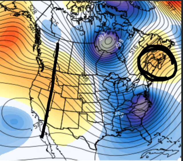
If by southern, you mean northern TN and Kentucky, sure.Another thing to note here is this is about as classic of a look for a southern snow storm as you can get. Weaker surface low that is right on the gulf coast instead of northern Mississippi, and a classic banana high with deep CAD and a strong high pressure over the top in the plains. Call me a crackhead but if this run continued I don't see how the LP could go north.
I'm not seeing that at all. The GFS continued a northward movement into Tennessee. The Nam was moving due east. Maybe ENE ever so slightly but is also much further south.If you loop the NAM from 75-84 you can tell it’s headed toward GFS location. Just slower doing so.
It moved NNNEI'm not seeing that at all. The GFS continued a northward movement into Tennessee. The Nam was moving due east. Maybe ENE ever so slightly but is also much further south.


Yes. NAM definitely slower this run for sure.
I agree, but I don't like how there is not a good push of dry air down into CAD areas (outside of NC, that is) That push is just not super strong and the low is already into MS.
I agree. The NAM shifted slightly toward the Euro solution over the GFS. We’re still way out and it’s anyone’s guess, but it’s too early for anyone to throw in the towel yet.If by southern, you mean northern TN and Kentucky, sure.
Oooooo negative tilt I see?

 ICON moved from the Alabama/Tennessee border to Southern Alabama and is nearly on the Gulf at 90.
Maybe we will start to see a shift back south on models for next 3 days.View attachment 104375ICON moved from the Alabama/Tennessee border to Southern Alabama and is nearly on the Gulf at 90.
Stronger High and better centered over NE.
Ice storm is back for the midlands of SC.
FWIW- JB this morning!
It Should Cut
The trough coming in over the West shore of Hudson bay and the ridge back near Boise and the LACK OF CONFLUENCE northeast of the storm all argue for the cutter


