L
Logan Is An Idiot 02
Guest
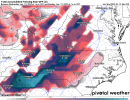
This run was better hopefully the GFS can follow shortly View attachment 104283
Interesting. Icon shows more of a backend thump instead of front end
Sent from my iPhone using Tapatalk
This run was better hopefully the GFS can follow shortly View attachment 104283
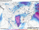
 good idea on who will be seeing the bulk of wintry weather for now. But wow. It’s been a while since I’ve seen a 30-50% chance of a winter storm in the southeast. View attachment 104288View attachment 104288


Hope so cause they will need to thaw out. It’s common for major winter storms to end as drizzle ?. Hopefully it does here too but very unlikelylol one more amped trend on the GFS and CLT May switch to rain. Lol


Charlotte to extreme ne ga has the exact same soundings..heavy sleet!Lol what a sleet sounding View attachment 104295View attachment 104296
Yall starting to make me feel guilty. But I'm holding by a hair if these trends continue.
6 inch probability. Huge run of the EPS for western NC
Sent from my iPhone using Tapatalk
While I hate the trends myself, typically models don’t go one way every single run until go time, especially with 108 hours still leftThat was a worse GFS run; especially for RDU folks (then up through DC). Looks like the storm traverses close to Raleigh (warm surface temps nears 50). RAH also acknowledging the models signaling an inland path for the storm once it transferred. The only thing I can go on is the storm will get better sampling starting tonight. Lets see if we can now get a few shifts in our favor.
I would take that with a huge grain of salt… soundings indicate that it’s mainly a heavy sleet storm in a lot of thatClose to 2" of ZR for GSP and 1.5" for CLT.
Maybe maybe not well see today and tomorrow will be telling.Guess we need to accept reality of a dangerous ice storm for the Carolinas.
Sent from my iPhone using Tapatalk
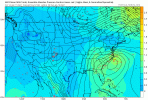
Yea thats a pretty good consensus of Euro, eps, gefs and to some extent the ukie.The 6z GEFS is almost identical to the 0z Euro in how it handles the transfer from the parent low to the coast. Low pressure forms close to Savannah and rides up the coast from there… that is so much more realistic than what the GFS is showing right now
6Z GEFS has the low exiting southern Georgia and hugging the coast. It has shown a very similar solution ever since 6Z yesterday. If nothing else it has been consistent so far.
6Z GEFS has the low exiting southern Georgia and hugging the coast. It has shown a very similar solution ever since 6Z yesterday. If nothing else it has been consistent so far.
I really don’t think the solutions of the Euro and GFS are comparable. The Euro still would give a good thump of snow initially to RDU before switching to sleet then ZR and then possibly to rain. The GFS solution, again develops the new low right in the middle of the CADAt this point, we have the GFS, euro, and CMC with an inland track (~ I-95). RDU eastward ends up switching to all rain or is all rain for the event. LOL---> I suppose we still have the Icon which runs the low up along the coast.
Knew this was going to happen. It was on island with that western KY / plow through wva output. Anytime you see the gfs on an island by itself, best to ignore it.The 6z GEFS is almost identical to the 0z Euro in how it handles the transfer from the parent low to the coast. Low pressure forms close to Savannah and rides up the coast from there… that is so much more realistic than what the GFS is showing right now


Yes that is the trend on the GEFS because you’re seeing less and less in the way of off shore tracks… I don’t believe the track will be off shore… I think the track the Euro shows makes much more sense and it’s supported by both EPS and the GEFSY’all keep grasping on the GEFS being different from the GFS, but the trend is plain as day obvious. The smoothed mean is just taking time to catch up.


We both could be wrong but will ride together! I like the overall pattern and consensus and low track/transfer that these have consistently shown. Personally believe the cad features hang tough and don't shower out that quickly. But again could be wrong.I'm sticking with The euro/ukmet/eps . Pretty good cluster/consistent. See how today trends;
Heres the Eps Track. Draw a line at hr 96 frame to hr 120 frame. Most likely scenerio imo. Gefs gives this alot of weight as well. Mobile area to Morehead City.
Euro Clown: Yes this has Ice: I dont have access to sleet /frzng rn maps: But Triad is all Frozen in some fashion:
Over an inch of qpf: This is the big take away as its all frozen in alot of areas:
The UKmet starts from almost the same identical spot as the EPS: Mobile vicinity:
ends up about 40-50 miles futher inland with its track:
This has alot of ice being counted as snow, but gives you a great idea where the frozen is :
Again total qpf over an inch: All frozen in alot of areas: