• Hello, please take a minute to check out our awesome content, contributed by the wonderful members of our community. We hope you'll add your own thoughts and opinions by making a free account!

Wintry Jan 15-16 Winter Storm Discussion & Obs

Still thinking a blend of of the ensembles until the features get sampled is the best course.of action. Hard to believe that Amping on the gfs when each run shows a stronger tpv
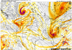
It's a tough call (as always)...I think the strength / amplitude of the wave plays a role. The 06 GFS and Euro Control are pretty strong with the wave as it runs down thru Wyoming / Nebraska. Higher amplitude wave is going to move a little slower which gives it time and room to bottom out and turn the corner in the SE. You can see that here on the 06z GEFS spaghetti chart where over the SE, the white line is the operational run and the green lines are each of the ensemble members. The operational run is on both the slower side and more amplified side (checkout the white line running thru Maryland on the eastern flank of the wave)

The western / west-central NC / N GA crowd is going to like this more amplified look, while those farther south and east are going to want to see a nice amplifying wave, but with it sliding more west to east as it bottoms out instead of running more SW to NE.

djb6z6i.png
 
Exactly. This is how you know the Op GFS is lying. Either the snow maps and precip type maps are wrong, or we're not going to have a 979 Low parking itself in the middle of a wedge.

Yeah its ridiculous the maps the GFS has....rain in the mts buts somehow its still snowing over the piedmont.... we need that thing to get phased in 150 miles east of SC then move up to offshore Hatteras then climb slowly up to the ENE....thats how the big boys happen, hell even Jan 2000 which was crazy amped kept the surface low east of Lookout and Hatteras and I got mostly rain here from that one....really us eastern NC folks need them weaker or way out there lol....bottom line is we need this to not dig so much SW so early and phase in later, nothing in the current runs is anything but pain for us unless we see it either less amped or more suppressed so it bombs further offshore.....the runs this morning are classic screwjobs....big rainy storm followed by big cold and clear....
 
In the case we do get an amped up low that is too far west, with such a cold airmass in place somewhere could get a major sleet/ZR event out of this.
 
If you live in central or even eastern NC I wouldn’t panic much .. this is cold and deep CAD. This means with these amped trends we’re looking at a thump of snow and sleet turning into either a sleet storm or ice storm .. obviously no one wants that for power and trees but that’s where we’re at .. I wouldn’t freak out if you wanted lots of snow though because this is still before the beasts deform band moves by us and with this nature of a system that type of deform band would easily drop an additional 3-6 to whoever it crosses paths with … this has potential to be an outstanding winter storm for our area
 
Yeah its ridiculous the maps the GFS has....rain in the mts buts somehow its still snowing over the piedmont.... we need that thing to get phased in 150 miles east of SC then move up to offshore Hatteras then climb slowly up to the ENE....thats how the big boys happen, hell even Jan 2000 which was crazy amped kept the surface low east of Lookout and Hatteras and I got mostly rain here from that one....really us eastern NC folks need them weaker or way out there lol....bottom line is we need this to not dig so much SW so early and phase in later, nothing in the current runs is anything but pain for us unless we see it either less amped or more suppressed so it bombs further offshore.....the runs this morning are classic screwjobs....big rainy storm followed by big cold and clear....
All i have to see is a low west of hatteras and its game over for most of NC.
 
If you live in central or even eastern NC I wouldn’t panic much .. this is cold and deep CAD. This means with these amped trends we’re looking at a thump of snow and sleet turning into either a sleet storm or ice storm .. obviously no one wants that for power and trees but that’s where we’re at .. I wouldn’t freak out if you wanted lots of snow though because this is still before the beasts deform band moves by us and with this nature of a system that type of deform band would easily drop an additional 3-6 to whoever it crosses paths with … this has potential to be an outstanding winter storm for our area
I think you're right. Once you get south of 64, this may end up being a hellacious sleet or ice storm if the amped solutions play out.
 
View attachment 103744
Jesus that is deep vort coming down. Closed off already as well.
Surface low over Dallas at the end of the run (I know 84 hour NAM - salt over shoulder), and it's heading SE toward central Louisiana and the closed upper low is heading nearly due south, about to crash into the panhandle of TX. It looked like a really good show was about to start in the SE!
 
All i have to see is a low west of hatteras and its game over for most of NC.
Ok can we have any more negative posts from the Triangle and east folks? Yes it is looking more amplified, but last nights Euro had us dry and suppressed. Yes we could rain or certainly mix, but I don’t see the need for this yet.
 
Surface low over Dallas at the end of the run (I know 84 hour NAM - salt over shoulder), and it's heading SE toward central Louisiana and the closed upper low is heading nearly due south, about to crash into the panhandle of TX. It looked like a really good show was about to start in the SE!
That was the next thing I was going to bring up. Due to the orientation of the trough this would likely swing south of I20 and probably closer to Savannah as it makes its way through with this look. That is a big deal if you want snow along and north of 20.
 
If you live in central or even eastern NC I wouldn’t panic much .. this is cold and deep CAD. This means with these amped trends we’re looking at a thump of snow and sleet turning into either a sleet storm or ice storm .. obviously no one wants that for power and trees but that’s where we’re at .. I wouldn’t freak out if you wanted lots of snow though because this is still before the beasts deform band moves by us and with this nature of a system that type of deform band would easily drop an additional 3-6 to whoever it crosses paths with … this has potential to be an outstanding winter storm for our area

Man a sub 1010 low over land in NC is rain all the way around for most folks east of the triangle, much less the 990ish stuff the models have...its would scrub out the CAD fast, the issue is more why are the models slamming these strong lows into such a strong TPV.....so most likely one of these two things is wrong....either the cold is not as strong and deep and the storm runs up inland and we all rain or the TPV is strong enough to keep this thing suppressed and east and we all crash the board with snow photos.....but as modeled on the last couple of runs its not anything but rain for NC.....

You would need to see the surface low at best right on the coast for the RDU and west crowd to have a chance at a ice storm....especially if its a sub 1000mb low....these maps with 987s over Roanoke Rapids are nothing but rain.....
You're reading too much in the LP placement. 1. A LP is not going to come that far inland with the type of CAD that is built into the region. The GFS has notoriously done this through the years. The LP is either going to pivot around the Cold Dome or transfer like a miller B.
 
Man a sub 1010 low over land in NC is rain all the way around for most folks east of the triangle, much less the 990ish stuff the models have...its would scrub out the CAD fast, the issue is more why are the models slamming these strong lows into such a strong TPV.....so most likely one of these two things is wrong....either the cold is not as strong and deep and the storm runs up inland and we all rain or the TPV is strong enough to keep this thing suppressed and east and we all crash the board with snow photos.....but as modeled on the last couple of runs its not anything but rain for NC.....

You would need to see the surface low at best right on the coast for the RDU and west crowd to have a chance at a ice storm....especially if its a sub 1000mb low....these maps with 987s over Roanoke Rapids are nothing but rain.....
WRAL has it so far offshore its mainly an outer banks threat.
 
All i have to see is a low west of hatteras and its game over for most of NC.
I’m sorry but that’s just not true… the February 2014 storm tracked just east of I-95 and there was widespread 6”+ totals for most of the western 2/3rds of the state. The key was how strong a CAD was in place and even the amped up GFS has had a comparable CAD setting up.
 
Man a sub 1010 low over land in NC is rain all the way around for most folks east of the triangle, much less the 990ish stuff the models have...its would scrub out the CAD fast, the issue is more why are the models slamming these strong lows into such a strong TPV.....so most likely one of these two things is wrong....either the cold is not as strong and deep and the storm runs up inland and we all rain or the TPV is strong enough to keep this thing suppressed and east and we all crash the board with snow photos.....but as modeled on the last couple of runs its not anything but rain for NC.....

You would need to see the surface low at best right on the coast for the RDU and west crowd to have a chance at a ice storm....especially if its a sub 1000mb low....these maps with 987s over Roanoke Rapids are nothing but rain.....
Key thing with 50/50 low / TPV etc is placement (in addition to strength)...the farther south and east it is located, and just as important, the farther south and east the appendages that rotate around it are located, the more suppression it will exert to the flow along the east coast
 
Somebody said Webber was throwing out a possible March 1980 like event. I think most NC folks would go for that!
ID_97.gif
I posted this earlier, but the pattern is becoming more analogous to March 1980
gfs-deterministic-namer-z500_anom-2280400.png

2013-2014 +PNA (2).png
*Note that the date is off, this is in fact March 1980.*
 
I’m sorry but that’s just not true… the February 2014 storm tracked just east of I-95 and there was widespread 6”+ totals for most of the western 2/3rds of the state. The key was how strong a CAD was in place and even the amped up GFS has had a comparable CAD setting up.
One other thing I'll add here is how the CAD is building. If building-in during the storm snow/sleet wins out. If retreating...getting scoured-out (which does not look to happen here) then yes you have more zr/rain.
 
Very similar. Notice the ridge/block above the PV is more favorably located now. If that turns out to be correct, then the southern solutions may have the advantage here.
It's hard to get a good grasp on just how far NW this can go. The econtrol favoring the gfs scares the crap out of me, the only other op that was well north was the icon but it wasn't for the same reasons. With the euro and cmc south you have to wonder if we see a little meeting in the middle here versus everything trending more and more NW
 
It's hard to get a good grasp on just how far NW this can go. The econtrol favoring the gfs scares the crap out of me, the only other op that was well north was the icon but it wasn't for the same reasons. With the euro and cmc south you have to wonder if we see a little meeting in the middle here versus everything trending more and more NW
If the 6Z EPS and Control were to be believed, the GFS is on to something.
 
Very similar. Notice the ridge/block above the PV is more favorably located now. If that turns out to be correct, then the southern solutions may have the advantage here.
So this means the could on track GFS could trend SE as we get closer if the Vortex stays in the same position? This could also mean it's more likely that the Midlands of SC/Eastern NC could see huge snowfall amouts as a result of this ,correct?
 
Back
Top