Blue ridge escarpment/foothill special. Lift going to give us some good rates up this way.Wow big increase and it wasn’t done, 4 inches at CLT ! View attachment 103719View attachment 103720View attachment 103721
-
Hello, please take a minute to check out our awesome content, contributed by the wonderful members of our community. We hope you'll add your own thoughts and opinions by making a free account!
You are using an out of date browser. It may not display this or other websites correctly.
You should upgrade or use an alternative browser.
You should upgrade or use an alternative browser.
Wintry Jan 15-16 Winter Storm Discussion & Obs
- Thread starter SD
- Start date
yea when i lived in raleigh we got screwed so many times with under modeled WAA. usually around 60hrs the NAM would start firing warning shots. if im RDU east i am praying for a less amped lp because if that thing cranks over those SSTs that are running 10+ than normal the waa will be killer.
As others have said, I think the triangle area knows how this story is likely to go...

Tokenfreak
Member
Fingers crossed we get some snow here in the lowcountry. I'm hopefully, although it may just be cold rain.

Said it last night but I’ll say it again. Bombing 50/50 low as depicted acts just like a -NAO. They do the same thing. We are seeing these big runs because of that. Need that thing to hold serve.
Snowflowxxl
Member
This has February 2014 written all over it
That was a fun storm. I think I was in 7th grade and it hit just as we came back from winter break. Out of school that whole next week.
For those of you keeping score at home:

If we get 8 inches to a foot you can have my admin position
If we get 8 inches to a foot you can have my admin position
HAHA....Well it's been since 2002 since we have seen 8" of snow so I am going to say I think you are safe.
Heelyes
Member
This storm was almost as good as the crusher here. My old Toyota was the only car on the road that morning and needed every bit of the 35 inch tires.
LickWx
Member
Jan 2002 RDU hit 80 . Jan 2022 RDU almost hit 80. Kind of interesting to see them looking similar .HAHA....Well it's been since 2002 since we have seen 8" of snow so I am going to say I think you are safe.
Storm5
Member
Temps are an issue for areas west of the Mountains . Gonna need the low close off and move head to maximize
Sent from my iPhone using Tapatalk
Sent from my iPhone using Tapatalk
ATLwxfan
Member
ATL mets, who in general are very sheepish when it comes to forecasting winter weather, are noticing.
Sent from my iPhone using Tapatalk
Sent from my iPhone using Tapatalk
Personally still one of my favorite winter storms of all time. Similar to Jimmy I was in the 3rd grade and had my winter break extended because of this storm. I still had patches of snow on the ground in the backyard for nearly 2 weeks. Even the mini snowman I made survived about that long although it was in a shaded area. Only other January storm that slightly edges it out for me is January 2011.
Shaggy
Member
Still thinking a blend of of the ensembles until the features get sampled is the best course.of action. Hard to believe that Amping on the gfs when each run shows a stronger tpv
Wind gust 44 mph ???From weatherforyou.com Atlanta, hmmm
Sunday Jan 16 
Day: Cloudy with snow. Highs around 34°F. Wind chill values as low as 20°F. East northeast wind to 18 MPH, gusting to 44 MPH. Chance of precipitation 70 percent. 
Night: Partly cloudy with rain and snow. Lows around 27°F. Wind chill values as low as 17°F. West northwest wind 9 to 14 MPH, gusting to 34 MPH. Chance of precipitation 20 percent. Monday Jan 17 
Day: Partly cloudy. Highs around 33°F. Wind chill values as low as 16°F. West northwest wind to 13 MPH, gusting to 31 MPH. Report ad
Sun & Moon Monthly Morning Twilight 7:16 AM 
Waxing GibbousSunrise 7:43 AM Sunset 5:47 PM Evening Twilight 6:14 PM
Contiguous United States Extremes
Weather Folklore
The moon her face be red, of water she speaks.


+-
Leaflet | © OpenStreetMap contributors, ©AerisWeather
Click here for Interactive Radar
Report ad
Already a Clear Sky subscriber? Click here to login
Report ad
More Roswell, GA, Weather Information
Weather Warnings
Doppler Radar
State Weather Conditions
Satellite
Report ad
WeatherForYou.com, LLC is not responsible for any damages or problems caused by this service. Current weather conditions for Roswell, GA, are obtained from the closest government operated station, a personal station contributing to the PWSweather.com network which may have varying degrees of accuracy or from the Meteorological Assimilation Data Ingest System (MADIS). WeatherForYou.com, NOAA and their data providers disclaim liability of any kind whatsoever, including, without limitation, liability for quality, performance, merchantability and fitness for a particular purpose arising out of the use or inability to use the data. Weather forecasts are powered by AerisWeather. Like all things, this site belongs to Jesus Christ... He just trusts us to maintain it. If you have any questions or comments email [email protected]
Copyright © 2021, WeatherForYou.com LLC. All rights reserved.

what is cool about these types of storms is it results in so many young kids turning into weather nerds. i know the crusher in 2000 really kick started my love of weather. nothing better than watching the weather channel in the days leading up to a storm and seeing my profile pic icon.
back on topic, really interested to see if we see models waffle a bit today into tomorrow as our storm is still over the pacific. usually see models lose these around this timeframe only to come back.
back on topic, really interested to see if we see models waffle a bit today into tomorrow as our storm is still over the pacific. usually see models lose these around this timeframe only to come back.
iGRXY
Member
If you're in the upstate or west of 77 in NC you should love the EPS individual storms. Almost all of the big dogs, and there are many, paint the largest swath of totals over these areas. To have the EPS showing this at this range is fantastic.
lexxnchloe
Member
Lets pray this trends back east. anymore west and its warm and rainy in most of NC.
Certainly a possibility if we get that amped up system but that is still way too early to worry about that just yet.Wind gust 44 mph ???
Man, high winds with ZR and wet snow driving that cold air in from the NE are the things weenie dreams are made of. If somehow we make it to tonight's runs with this bad boy still showing I think I'll have to see if that generator I haven't used in ten years still runs.Wind gust 44 mph ???

Showmeyourtds
Member
ATL mets, who in general are very sheepish when it comes to forecasting winter weather, are noticing.
Sent from my iPhone using Tapatalk
Kiss of death. My wife is due any minute with our first and my nightmare was that the little guy would show up ahead of or during a potentially epic winter storm that I can't enjoy.
ATLwxfan
Member
Kiss of death. My wife is due any minute with our first and my nightmare was that the little guy would show up ahead of or during a potentially epic winter storm that I can't enjoy.
Umm…don’t tell the kid that.
Sent from my iPhone using Tapatalk
Western ridge trends stronger as well. Gives a deeper more western track and amps up more as well.Mentioned this yesterday...we see this almost every time we have a modeled 50/50 at day 6...it tends to lift out quicker. But, this allows a more amped event but probably will end in misery for some and joy for others.
View attachment 103737
Eastern 1/3 maybe but not most of NC, those out west are in a very good spotLets pray this trends back east. anymore west and its warm and rainy in most of NC.
SnowNiner
Member
If you're in the upstate or west of 77 in NC you should love the EPS individual storms. Almost all of the big dogs, and there are many, paint the largest swath of totals over these areas. To have the EPS showing this at this range is fantastic.
Yeah, but there's a lot of nothing burgers as well. Still lots of spread. Big dogs and dry clippers too IMO. Interesting to track for sure.
Downeastnc
Member
Yep we gon rain. Hopefully we have enough CAD that we at least get a little ip/zr before changeover
Yep you cannot have the surface low track right on or inland of the coast if you want snow from I 77 east.....I dont care what the maps show, if there is a 987 low anywhere west of Lookout and Hatteras we gonna rain.....all of us even the mts....maybe some ice in the NW piedmont can hold on for a bit but we need this way less amped or for it to do what it is doing 200 miles further east.....
Snownut
Member
I think this will be one for the Record books for those in WNC and upstate
Sent from my SM-A526U using Tapatalk
Sent from my SM-A526U using Tapatalk
lexxnchloe
Member
Yes, if there is no more west trend the west is good but if it continues west its the usual NC rainstorm. 06 GFS already has rain well north into VA.Eastern 1/3 maybe but not most of NC, those out west are in a very good spot
lexxnchloe
Member
I agree. too far west already.Yep you cannot have the surface low track right on or inland of the coast if you want snow from I 77 east.....I dont care what the maps show, if there is a 987 low anywhere west of Lookout and Hatteras we gonna rain.....all of us even the mts....maybe some ice in the NW piedmont can hold on for a bit but we need this way less amped or for it to do what it is doing 200 miles further east.....
iGRXY
Member
Of course there's going to be ensemble members that have nothing. Rarely do you get everyone to show storm at day 5. But A ton have monsters and that is very encouraging at this range.Yeah, but there's a lot of nothing burgers as well. Still lots of spread. Big dogs and dry clippers too IMO. Interesting to track for sure.
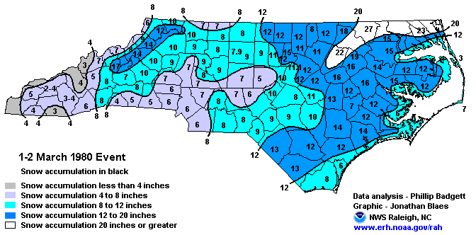
Somebody said Webber was throwing out a possible March 1980 like event. I think most NC folks would go for that!
Exactly. This is how you know the Op GFS is lying. Either the snow maps and precip type maps are wrong, or we're not going to have a 979 Low parking itself in the middle of a wedge.Yep you cannot have the surface low track right on or inland of the coast if you want snow from I 77 east.....I dont care what the maps show, if there is a 987 low anywhere west of Lookout and Hatteras we gonna rain.....all of us even the mts....maybe some ice in the NW piedmont can hold on for a bit but we need this way less amped or for it to do what it is doing 200 miles further east.....
SnowNiner
Member
Of course there's going to be ensemble members that have nothing. Rarely do you get everyone to show storm at day 5. But A ton have monsters and that is very encouraging at this range.
Yeah. I'd just prefer to have a higher percentage of members with decent hits, rather than a lower percentage of big dogs at this range. Just a preference. The all or nothing runs make me more nervous. Especially since this is such a unique clipper-like system that we don't normally see.
- Joined
- Jan 5, 2017
- Messages
- 3,806
- Reaction score
- 6,063
ATL mets, who in general are very sheepish when it comes to forecasting winter weather, are noticing.
Sent from my iPhone using Tapatalk
Yeah, the NWS is going to need to go ahead and alert GADOT. They need to start mobilizing if there is indeed 6" + somewhere in North Georgia. I'm not surprised that the possibilities are being mentioned. Way too early for details, though. The means are still low south of Atlanta.
iGRXY
Member
Through 51 the NAM has the TPV a little further southwest but the vort coming into the PNW is definitely strong and already closed off compared to 6z
NBAcentel
Member
Really favoring the I-85 corridor and NW in this setup with the current look
This can somewhat apply to the midlands of SC. The 6Z GFS wasn't too far away from a pure rain event towards my way. For the Midlands of SC and eastern NC,we need to hope that the CMC is the most correct here, which brings the storm off the coast and keep the warmer temperatures at bay. The CMC is basically a blend of the 6Z GFS and the 0Z Euro. Amped enough to bring large snow totals,but not too amped to point where a lot of us have to deal with temperature issues.Yep you cannot have the surface low track right on or inland of the coast if you want snow from I 77 east.....I dont care what the maps show, if there is a 987 low anywhere west of Lookout and Hatteras we gonna rain.....all of us even the mts....maybe some ice in the NW piedmont can hold on for a bit but we need this way less amped or for it to do what it is doing 200 miles further east.....