NBAcentel
Member
Consistently getting a range around 3.7-4.0” amounts here, basically 3.7-4” is the total in the books here for this event 
Where are you in H’borough? Just curious.Im getting heavier now than I did this morning ?
Across from the hospital.Where are you in H’borough? Just curious.
The GFS had the ULL UP into western KY for several runs.The best long range model was the GFS. I think the 3K NAM did the best with temps here, HRRR and RAP were too cold.
True. I guess all the models has their ups and downsThe GFS had the ULL UP into western KY for several runs.
In terms of Storm track, the GFS did horrible. It repeatedly pushed the ULL up into TN and KY.. I don’t give it too much of hit on that because all the models did poor with it… the ULL ended up going along I-20 and then I-85. As for the surface low, the GFS repeatedly developed the new low well too west, even inside the CAD. Finally the GFS eroded the CAD way too much, but we all know that’s a bias of the globals. Track wise, it feels like the Euro and UK did the bestThe best long range model was the GFS. I think the 3K NAM did the best with temps here, HRRR and RAP were too cold.
The UK was far too south until 48 hoursIn terms of Storm track, the GFS did horrible. It repeatedly pushed the ULL up into TN and KY.. I don’t give it too much of hit on that because all the models did poor with it… the ULL ended up going along I-20 and then I-85. As for the surface low, the GFS repeatedly developed the new low well too west, even inside the CAD. Finally the GFS eroded the CAD way too much, but we all know that’s a bias of the globals. Track wise, it feels like the Euro and UK did the best
Sorry I actually meant the Icon, which pains me to say since I do not think much of that modelThe UK was far too south until 48 hours

It started getting windy when the winds shifted northwest away from the wedge. We are getting all of Chattanooga’s warm air. I dropped to 31.6 around 6pm, then all the way up to 34 after the wind shift. 33.4 now, and has been for hours.The wind is really howling outside. Also it’s still 34 outside, I never got under 32 the whole event ?
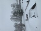
 Picture of the street. This is the reason that I like snow.
Parts of SC saw 0.5 of ice, especially around pageland SCDid anyone actually get a massive ice storm out of this or were the models over doing that like usual?
Sleet saved me... There was some ice in the trees but not as much as there would have been without sleet. It was enough sleep for probably half an inchDid anyone actually get a massive ice storm out of this or were the models over doing that like usual?
Did anyone actually get a massive ice storm out of this or were the models over doing that like usual?


 and COLD!