Heelyes
Member
I almost feel bad saying this but it's picking up.
Thanks for the downwind report. Expecting it to start any second here.I almost feel bad saying this but it's picking up.
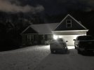
Heavier returns headed to me. Hopefully I didn’t get out of bed for naughtWow legit snow shower here in apex!


Actually I just spoke with family near Sanford and it snowed there in that band.
Do you mind if I ask which dorm? My daughter goes to StateDorm fire alarm going off neat everyone will get to see it if it snows
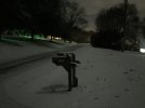
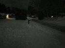
Snow is starting to mix