Sleet still ripping. Wind starting to roar up as well. Blowing horizontal now
-
Hello, please take a minute to check out our awesome content, contributed by the wonderful members of our community. We hope you'll add your own thoughts and opinions by making a free account!
You are using an out of date browser. It may not display this or other websites correctly.
You should upgrade or use an alternative browser.
You should upgrade or use an alternative browser.
Wintry Jan 15-16 Winter Storm Discussion & Obs
- Thread starter SD
- Start date
LukeBarrette
im north of 90% of people on here so yeah
Meteorology Student
Member
2024 Supporter
2017-2023 Supporter

campamy
Member
Staying all snow for awhile now. Deck is white and the grass is turning white!
Snowflowxxl
Member
Light accumulations again
I guess we’re going to escape with minimal icing at this point given surface temps are creeping up close to freezing and the IP continues. Might changeover for a little bit, but no way we’re getting 0.2”+ like forecasted.About an 1" of snow/sleet here. Just a wee bit of freezing rain so far.
Temp is 30.2 and slowly creeping up
View attachment 106767
Ward Cleaver
Member

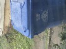
Now that’s a pile of sleet. ?
cd2play
Member
Nashville FINALLY changed over just prior to 11:00 AM. It's been ripping since!
nbellenburg
Member
Simpsonville has transitioned back to pretty much all snow with some very fat flakes mixed in. We were all sleet for about 4 hours. Very little ZR. Maybe a glaze at best. ZR forecast here was way overdone.
Heaviest snow of the day so far, 32.2F/32.2
NEGaweather
Member


Sent from my iPhone using Tapatalk
We’re in premature birth phase of an icing event .. also probably 1.5 snow/sleet accumulation here in Apex NC after it’s compacted down to 1 inch 


packfan98
Moderator
Wow! It’s straight pouring rocks outside. Super windy too.
One of my favorite parts of sleet is how it comes off the roof and makes those huge piles. Haha. I remember we got some 3’ piles of sleet back in a storm back in the early 2000s back in GSO where three sections of roof slanted down into a single crevice by the garage. Crazy stuff! Noticing a bit here now as well!View attachment 106778
Now that’s a pile of sleet. ?

13 inches now. 20 inch drifts
- Joined
- Jan 2, 2017
- Messages
- 1,568
- Reaction score
- 4,283
Measured on truck hood have 4' solid now and coming down steady

VegasEagle
Member
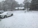
Example of how crazy this system is
Snow_chaser
Member
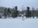
This is amazing, some of the heaviest rates of the event. Visibility droppingIt's happening right over my head at the moment
Stephenb888
Member
Jlaw0097
Member
I'm getting freezing rain now, but even here it shouldn't be too bad:I guess we’re going to escape with minimal icing at this point given surface temps are creeping up close to freezing and the IP continues. Might changeover for a little bit, but no way we’re getting 0.2”+ like forecasted.

Wheres weathernc or Mcdowell obs?
2.75 inches of snow and sleet. No freezing rain. Near Cowans Ford Dam. Lake Norman
Iceagewhereartthou
Member
Heavy snow!
Weatherheels
Member
Raging sleet storm taking place. Around 3” snow/sleet on the ground. Wind has been gusty all morning, seem to be picking up some steam now. Still hovering around 22 degrees. Guilford/Forsyth county line.
- Joined
- Jan 23, 2021
- Messages
- 4,604
- Reaction score
- 15,203
- Location
- Lebanon Township, Durham County NC
I’m honestly surprised how long sleet has held on here.
Best band in a couple of hours is overhead now. Really needed this to fight off ole Sol for the next couple of hours.
D
Deleted member 609
Guest
I'm still getting sleet mixing in down here.I’m honestly surprised how long sleet has held on here.
drfranklin
Member
- Joined
- Dec 1, 2016
- Messages
- 511
- Reaction score
- 760
precip has changed to snow on I85 corridor in Upstate SC - light to mod snow here
Trying to flip back to all snow here
- Joined
- Jan 23, 2021
- Messages
- 4,604
- Reaction score
- 15,203
- Location
- Lebanon Township, Durham County NC
HRRR still has half an inch of ZR in Orange and NW Durham
Bannerdude
Member
Last 30-45 minutes of below freezing precip will be freezing rain, sleet is no more
Transferring energy to coastal and it's about to go boom, look at the cooling cloud top streaks along SC coast


MichaelJ
Member
currently moderate sleet, winds up to 25mph and 22.4/16.8 wind chill of -3
Ditto. It hammered to.I’m honestly surprised how long sleet has held on here.
Noticed we get snow sounding back around 6 to 630. Future radar shows a nice little band around 830 to 930. Mtns have a big backside band at this time. Be a great way to cap off with a half inch to inch. We have had to had over 2 inches of sleet heading toward 3. This on the inch of snowfall.
32.4 temp slowly rising but all frozen over here now obviously, looks like about .1-.15 of ice accrual. Pressure dropping too and winds should start to crank in a few hours
iGRXY
Member
Light freezing rain here but you with 850’s crashing and under freezing this is due to no moisture yet in the DGZ but snow reports back in Greenville tells me that’s changing quickly. Honestly looks like some snow trying to mix with it but it’s too hard to tell yet.
Snowflowxxl
Member
Flake size finally increasing! Dropping quarters now and accumulating much faster
dawg
Member
What part of Durham are you in? I’m in the SW part near 40 off 15-501 like a mile from the Orange County line and haven’t noticed any ZR yet.Last 30-45 minutes of below freezing precip will be freezing rain, sleet is no more