LukeBarrette
im north of 90% of people on here so yeah
Meteorology Student
Member
2024 Supporter
2017-2023 Supporter

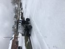
Really coming down now
What part of Durham are you in? I’m in the SW part near 40 off 15-501 like a mile from the Orange County line and haven’t noticed any ZR yet.
Gotcha, makes sense you’d start mixing a bit earlier then. Actually looks like there’s some ZR mixing in here now, as well.Lynn/Pleasant Road area off Hwy 70, 5ish miles ESE of downtown


I’m 10 miles north of Roanoke there in Alabama on Potash Ridge. It’s been snowing here since 8am. Still coming down good.I’m curious to see how heavy the rates are in this because I’m getting moderately thick snow again right now ahead of it.
You are a good 3-4 degrees cooler than every other location in Atlanta. Impressive.Very heavy in Druid Hills,,,29.6

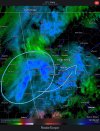
Yeah that back into AL and NW Ga looks impressiveTransferring energy to coastal and it's about to go boom, look at the cooling cloud top streaks along SC coast
View attachment 106792


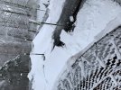
Coming down good here in Bowdon too.Randolph County Alabama. It’s coming down really heavy at the moment.
Snow in Anderson SC for the last hrLight freezing rain here but you with 850’s crashing and under freezing this is due to no moisture yet in the DGZ but snow reports back in Greenville tells me that’s changing quickly. Honestly looks like some snow trying to mix with it but it’s too hard to tell yet.