-
Hello, please take a minute to check out our awesome content, contributed by the wonderful members of our community. We hope you'll add your own thoughts and opinions by making a free account!
You are using an out of date browser. It may not display this or other websites correctly.
You should upgrade or use an alternative browser.
You should upgrade or use an alternative browser.
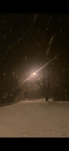
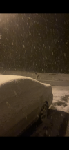
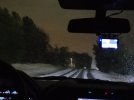
Wintry Jan 15-16 Winter Storm Discussion & Obs
- Thread starter SD
- Start date
?

How’s the ground looking back your way?Dry slot coming in for Atlanta.
DCK
Member
Noticed that as well.Dry slot coming in for Atlanta.
Iceagewhereartthou
Member
Wow, just eyeballing I've got 3.5 - 4 here in Easley. If i can stay all snow for that heavy stuff coming in i could be pushing 6. Temp at 29.8. This is awesome!
jaymackd3
Member
I can hear ice pellets hitting my window...starting to mix here
Snowflakes are falling!!
NoSnowJoe
Member
We just lost power.
NoSnowATL
Member
WetHow’s the ground looking back your way?
NBAcentel
Member
Probably getting close to a inch 
Snownut
Member
If it can snow another couple hrs in upstate, we may just be able to dodge the ice storm part of it
Sent from my SM-A526U using Tapatalk
Sent from my SM-A526U using Tapatalk
iGRXY
Member
HRRR lead the way but even it’s struggling with the dynamic cooling as the snow line is further south than what the HRRR just initialized with. That’s based on current radar and mPING reports

HSVweather
Member
Central AL

 Darn, the HRRR initialized almost a degree warmer at 850mb.
EastMSweatherguy
Member
GarnerNC
Member
Snowing in Garner
No snow for you
Member
- Joined
- Dec 28, 2016
- Messages
- 583
- Reaction score
- 890
The big bowl we put outside to catch the snow for kids is already overflowing. Dumping fatties here in Greenville SC
Heelyes
Member
It's nice when every flake sticks around. No melting so far with a dusting
Jessy89
Member

Turning to sleet now. Looks like we finished around 4 inches definitely a good storm
Sent from my iPhone using Tapatalk
iGRXY
Member
Also the ULL just seems south of guidance and is still moving SE and digging instead of cutting. Surface low and 850 also looks like it’s headed straight for the upstate instead of up the apps.
Windergawx
Member


27/23 Wind NNE 4
All sleet. Once again, snow 3 miles to my north.
All sleet. Once again, snow 3 miles to my north.
HSVweather
Member
Changeover from rain to snow is entering northwest AL

?cold. The same way SD likes his sleet.
FamouslyHot
Member

Freezing rain, IP and some fat snowflakes are all falling at once under this band. You can see the dynamical cooling happening in real time. What started as a few flakes mixed in is now about 50% of what’s falling
I'm impressed how quickly precip making it to the surface as dry as this air mass is, good signs for an extra hour of frozen maybe
Getting some steady flurries here just north of Baton Rouge. Temperature at 33.
Last edited:
Snownut
Member
That's a good thing that should minimize the ice especially north of 85Also the ULL just seems south of guidance and is still moving SE and digging instead of cutting. Surface low and 850 also looks like it’s headed straight for the upstate instead of up the apps.
Sent from my SM-A526U using Tapatalk
Been snowing pretty good for past 15 to 30 mins. Sticking everywhere right off the bat.
Hrrr shows this. Stays healthy for the upstate throughout event it appearsDry slot coming in for Atlanta.
Weatherheels
Member
Glad you added location. At first I saw Chapel Hill and was like hold up now, lol!
Light snow falling in Kernersville sitting at 25.
iGRXY
Member
Combination of a deep CAD and very heavy rates is keeping that warm nose south of modeling right now
Its all fun and games until I lock people out of threads. Ice cold son?cold. The same way SD likes his sleet.
Now its pouring snow! Weirdest storm I have seen but no complaints!
Zr in honea pathCombination of a deep CAD and very heavy rates is keeping that warm nose south of modeling right now
GarnerNC
Member
Already have a quick coating before the flip. Most we've had in 3 years.