Current SE obs:

Right down the road from you in Monroe. 40.8 winds ENE 5.8. Definitely saw a TON of squirrels and birds this morning running around like crazy. They are better indicators than these dang models a lot of times ?I moved from Social Circle 20 years ago thinking that an extra 10 miles north might help one day...not. Sadly, when we bought this house, it was down to this one and another in Habersham. The wife won that round.
38.3 with a light ene wind currently. Forecast high of 51. Let's see if we can top out below 45!
Your on a good spot man you'll get smoked be prepared to hunker down and enjoy I'm going to attempt buck creek N.C 80 tomorrow around noon give some obs on the warm nose along the blue ridge. N.C 80 takes you to the base of Mt. Mitchell 3800ft at Buck creek GAPI appreciate it! This cabin has Hughes Net internet service..not really any service out here but we’re only about 10 minutes from I26. Hoping ALL utilities remain in tact.
anyone have a good temp site to watch the cad build in?


I noticed that. I was hoping for an hour or two of snow before the change over here, HRRR and Euro still gives us a shot. The air may just be too dry before heavier returns move in.3km NAM doesn't have precip reaching the triangle until 15z-16z tomorrow.
View attachment 105886
and by 20-21z RDU is above freezing. Hopefully we won't have to worry to much about losing power.
View attachment 105890
I noticed that. I was hoping for an hour or two of snow before the change over here, HRRR and Euro still gives us a shot. The air may just be too dry before heavier returns move in.
I may be wrong but perhaps dynamic cooling? Areas of heavier precipitation would fall as snow.NAM still showing wraparound show in Alabama fwiw. Still not understanding how part of North Alabama get rain and parts of South Alabama get snow
Yep. Whatever happened to all of the FGEN models had been showing ? I guess it went poof.The only hope Raleigh has of seeing snow will be if precip gets here much quicker….ala 2014.
It's there and there's plenty of it but it doesn't get here until 18zYep. Whatever happened to all of the FGEN models had been showing ? I guess it went poof.
HRRR continuing to keep Blount and Etowah counties in the game.
3km NAM doesn't have precip reaching the triangle until 15z-16z tomorrow.
View attachment 105886
and by 20-21z RDU is above freezing. Hopefully we won't have to worry to much about losing power.
View attachment 105890
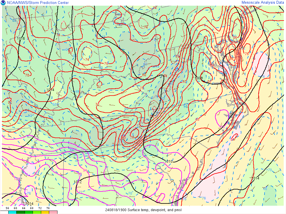
CAD has nothing to do with whether it snows in AL or not. It’s all about the 500mb low placement and if there is any moisture left over.A little more oomph with the CAD and NE Jefferson could come into play
Sent from my iPhone using Tapatalk
It will for the Northeast quadrant of the state. Where a winter storm watch or advisory could be issued depending on the trends of how the CAD does. On the backend of the low.CAD has nothing to do with whether it snows in AL or not. It’s all about the 500mb low placement and if there is any moisture left over.
40 and cloudy here where I’ll be riding this out 6 miles east of Alpharetta, GA
NWS Atlanta has done a great job with this one so far.
I threw a Atlanta specific call map in the other thread and would love to hear some takes over there or on Twitter. It could easily bust.
Let’s reel it in boys and girls. Stay safe!!
I mean this is brutal even if you take 25% off these values
Yes, you sacrificed my friend! Currently 40f ENE 6 mph. I see where they’re saying CAD moving into Bama so one would think we can overperform on this side of townI moved from Social Circle 20 years ago thinking that an extra 10 miles north might help one day...not. Sadly, when we bought this house, it was down to this one and another in Habersham. The wife won that round.
38.3 with a light ene wind currently. Forecast high of 51. Let's see if we can top out below 45!
It will for the Northeast quadrant of the state. Where a winter storm watch or advisory could be issued depending on the trends of how the CAD does. On the backend of the low.
Yep. Looking at Wunderground, the PWS’s east of the connector and 400 are almost all E and ESE winds. The ones on the west side are almost all W and SW. There be the battle zone - and I’m smack in it.Wow, I've had an East/ENE wind now for a little while...just goes to show you how just being even 25 miles east of ATL can have a difference in the wedging.
This is false.Not an event for Huntsville
Models show cad still affecting Northeast quadrant of Alabama through Sunday, can't say it won't reach subfreezing here. Temps are already forecasted at 33/34 by the time the backend of the system comes through. Along with winds coming from the Northeast from the apps through Sunday.CAA winds on the backside of the system will be coming in from the northwest which isn't associated with the wedge. The wedging only truly matters for the frontend of the system and the subfreezing temps simply won't reach AL from the wedge...they barely reach the Atlanta area
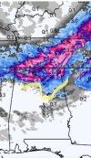
Light rain with an occasional ice pellet here in HSV.Returns showing in N AL & N GA. I wonder if that is reaching the ground. Don't remember seeing it modeled this early. Looks like a little snow in NE GA already.
Definitley reaching ground here on Monte Sano.Light rain with an occasional ice pellet here in HSV.
Is there a certain temp/dew at a certain time you would like to see for DAH to really get in on all that HRRR snow? Or does surface temp matter less still cause of WAA? I’m wondering how you will be tracking this in real time?38.6 here in Dahlonega. East wind