Nashville Disco. Nobody wants to make a call.....
Area Forecast Discussion
National Weather Service Nashville TN
841 PM CST Fri Jan 14 2022
.UPDATE...
FOR EVENING DISCUSSION.
&&
.DISCUSSION...
Cool and cloudy at update time. Pretty quiet out there. We`ll take
it because the next couple of days are going to be hectic. I`m not
going to go into a bunch of in-depth analysis here, mainly because
the 00Z model suite hasn`t come in yet. I`ll leave that to the
overnight crew. What I will say is that several places in Middle
TN look like they`re going to get more snow than they bargained
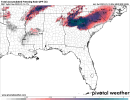
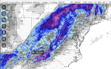
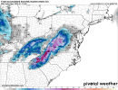
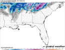
for Saturday night and Sunday. Yes, models are all over the place
as far as positioning where the heaviest snow is going to fall,
but if there`s anything they agree on, someone (or a large swath
of someones) is gonna get hammered. Of note, the 00Z HRRR has
finally started to show
heavy snow accumulation. I mention this,
because arguably, the HRRR did the best with the last two snow
events across the mid-state. That said, I have also seen evidence
of forecast soundings showing strong
Omega signs in the
dendritic
growth layer across a good swath of I-40 and south. How`s that
for scientific? Basically, it means
heavy snow for a period of
time.
All of this is leading to potentially 4-8 inches of snow across a
good portion of the area and I wouldn`t be surprised to see a
couple of spots see more and even a few spots (probably our far
northwest counties) see something closer to an inch.
I think the bottom line is: be prepared. Many places are going to
get a bunch of snow and everyone knows how even an inch of snow
can cripple TN when it comes to travel and traffic. Be prepared
for major travel impacts by late Sunday morning, lasting through
the night and probably even worse Monday morning in the aftermath
as temperatures in the morning should bottom out in the 20s,
freezing over anything liquid on the roads. Afternoon
temperatures Monday will try to inch towards 40 but I`m seeing a
lot of clouds Monday, so the sun may not be out to help melt
anything on area roadways. Hopefully by Tuesday, we can start
getting things back towards
normal.


