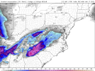
• Hello, please take a minute to check out our awesome content, contributed by the wonderful members of our community. We hope you'll add your own thoughts and opinions by making a free account!

Wintry Jan 15-16 Winter Storm Discussion & Obs

Having Augusta in the same zone as the north and eastern suburbs of Atlanta makes me discredit his map completely, sorry.


View attachment 104554
Yea personally given how this CAD is, discluding most of Hall and Forsyth seems like a mistake unless the CAD severely underperforms.
 
Looks like a consensus is forming about this storm. Barring any further shifts North and West, all areas outside of the NC/Tenn mountains will have an ice storm of varying severity. Worst areas for ice accumulation will likely be the Upstate up through Charlotte and into parts of Central NC while the Triad west (until the mountains) may be saved by snow and sleet with just a little ZR. Whatever the outcome of this one, the indices look fantastic for the next 2 weeks and a storm around the 21-22 could very well happen with better results for all.
 
fwiw:

WPC says:
The blend for the updated WPC medium range forecast used a general
model consensus (leaning more towards the ECMWF) for days 3-4.
After that, began incorporating some modest amounts of the
ensemble means to help temper the late period uncertainties.
Overall, this led to a fairly consistent forecast with the
overnight WPC package.
Hmmmmm.. WPC using Euro, TWC calling it an outlier! I know who I’m rolling deep with!?
 
Yea personally given how this CAD is, discluding most of Hall and Forsyth seems like a mistake unless the CAD severely underperforms.
Makes sense to me. Most of the precip will be over in the atlanta burbs before the wedge front arrives. It should arrive earlier near Augusta and back edge of the precip axis will go through them later.
 
Said the same thing about that being from this morning, but I looked at my forecast and they have all snow for it so the thinking is clearly remained so far.
You're right, mine is still there as well. It's a miracle! lol.

Afternoon discussion states they're going with a blend of the Euro/Canadian ensembles. Obviously if the current trend stays overnight it'll look much different tomorrow. Gonna root for the Euro to win out here though with the more southern track to get more of a front end thump.

1642019336976.png


As of 240 pm EST Wednesday: The forecast for the weekend remains in
a state of flux. Readers are advised to continue to manage their
expectations. On the one hand, confidence continues to increase
that we will have a winter storm that will probably impact the
entire forecast area beginning Saturday night and continuing
through most of Sunday. Precip probs are now into the categorical
for that time period. On the other hand, details about precip-type
distribution are very murky in both space and time, and that is
having a negative impact on confidence. The latest problem is
the operational GFS solution, which has trended toward moving the
850 mb low well west of the mtn chain, allowing for strong warm
advection that would establish a warm nose in most places east
of the mtns. The result would be a steady changeover/mix to sleet
and freezing rain, if the operational GFS is correct. It is worth
noting the 12Z GEFS is still holding onto snow as the most likely
p-type at GSP, but there is enough of an increase in sleet/freezing
rain outcomes that places like CLT have an almost equal chance of
the primary p-type being any one of the four. Meanwhile, the ECMWF
keeps its 850mb low moving overhead/southeast of the mtn chain. The
operational ECMWF would allow for a long enough period of time for
snow to fall east of the mtns before a weaker warm nose pokes up
from the south to changeover along/S of I-85.
Worth considering is
that in most situations, the warm nose wins across the area south of
I-85. Still way too early to consider amounts of individual p-types,
but the trend in the QPF has gone up substantially, which will
in turn flow down into the precip accums. The forecast guidance
blend used to create the new fcst will sometimes show a lag that
does not quickly jump to any new trend, so for the time being,
the fcst will look more like the cooler ECMWF/Canadian ensembles
instead of the more icy GFS.
High temps will not get out of the
mid-30s. Eventually, as the system passes, a change back toward
light snow should happen late Sunday.
 
Having Augusta in the same zone as the north and eastern suburbs of Atlanta makes me discredit his map completely, sorry.


View attachment 104554
I wouldn’t be surprised at all if the north and east Atlanta suburbs get in on that front end snow band for a few hours Sunday morning before changing over to freezing rain. I would even say that we may end up below freezing all day Sunday based off some of the models. Kinda feels like Feb. 2014.
 
I wouldn’t be surprised at all if the north and east Atlanta suburbs get in on that front end snow band for a few hours Sunday morning before changing over to freezing rain. I would even say that we may end up below freezing all day Sunday based off some of the models. Kinda feels like Feb. 2014.

Euro was pretty damn close even for my backyard to see frontend snow. I'm sure that's what some of the ensemble members are seeing which is why I have a 3-4 inch snow mean over my backyard.
 
Back
Top