iGRXY
Member

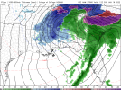
We’re in the gulf instead of central Alabama like 18z
This thing should start firing pretty good in the next frame of so.View attachment 105234
We’re in the gulf instead of central Alabama like 18z
It's still the same wave orientation. There's just a meso-low that forms over ALT.View attachment 105234
We’re in the gulf instead of central Alabama like 18z
Kinda bullish on the snow/sleet amounts lol


Same for central TennesseeFor some reason this NAM run is snowier in WNC


Do you think it’s picking up on the FGEN band better like the Euro was showing? Rates in a band like that can fight off the warm nose for a time..For some reason this NAM run is snowier in WNC
Our friend in Alcorn County, MS will approve of this map as do I!boom...so far


I’m all in on the backend snow at this point. It’s looking likely Atlanta is gonna be 34 degree rain for the main batch.
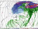
Really shows that dynamical cooling temporarily offsetting the warm nose in December 2018 fashionFinal frames
Yeah.., I really like the sounding down my way as well… definitely still some details to iron outThis sounding here is probably the best I’ve seen on the nam yet during the middle of the event, kinda surprised, perhaps because the cutoff was a tad weaker View attachment 105242


Final frames