CMC keeping hope alive!

Yes. Prime setup. This one has legsCMC keeping hope alive!View attachment 129279View attachment 129278


I personally put more weight into the MJO than anything else when it comes to cold. We shall see.Word from JB-
January 3, 2022
I'm in a State of Confusion by the disagreement between each model's MJO and surface temperature forecasts.
Originally our idea for January was that the warm MJO signals would bring the end of winter after the colder start. The years 1951,1990, and 2006 served as analogs for this.
The analogs above are very close to the recent CFSv2 forecasts:
When I saw that the MJO is in fact staying away from the warm phases, I realized the premise was incorrect. This is why I believe the pattern will cool down significantly after the first ten days.
As I said though, the confusing part is that models' MJO forecasts are becoming stronger into cold phases, while their United States temperature forecasts continue to be warm.
All these forecasts bring us to Phase 8 by Week 2, which is a strong indicator for cold, yet surface temperature forecasts are still extremely warm.
My take is that the pattern will shift to cold, as ridging breaks down over the Eastern United States and the ridge sets up back over Western Canada. I simply don't see how we can see a warm pattern with such a strong cold signal in the MJO.
But for now either me or the models are in a State of confusion

I can’t remember the last time it rained this hard. This morning was wild. I’m warshed out, Mack.Droughtbuster View attachment 129287
Yea its been a frog strangler-2.94" since 4pm yesterday. A boat load of thunder and lightning. The 13th is a lock now!I can’t remember the last time it rained this hard. This morning was wild. I’m warshed out, Mack.
Absolutely, NWS was calling for 1/4” for my area last night and I’m pretty sure we surpassed that! I don’t have a rain gauge to be exact though. I wonder how much the next few weeks will put us above drought range in South Central NCDroughtbuster View attachment 129287
Currently freezing drizzle and 31I can’t remember the last time it rained this hard. This morning was wild. I’m warshed out, Mack.
And they say people in the south overreact and can’t drive in those conditions ?Currently freezing drizzle and 31
Good times! Roads are garbage


Teleconnections are awful after mid month. NAO remains positive. AO goes toward positive and PNA heads toward negative.
Spin it however you will the MJO is all that's good..can it win out or do we blow phase 8 like we blew the -NAO?
ATTACH=full]129289[/ATTACH]View attachment 129290View attachment 129291View attachment 129292
Lol! They shut down the main road through Iowa around me. HWY 20And they say people in the south overreact and can’t drive in those conditions ?

I can confirm those red hues mean business. It’s like a waterfall. No moisture robbing convection to the south and it’s unloading gulf moisture.CAE about to get buried today based on this radar and trajectory, flooding very probable. Stay safe everyone.
CAE about to get buried today based on this radar and trajectory, flooding very probable. Stay safe everyone.
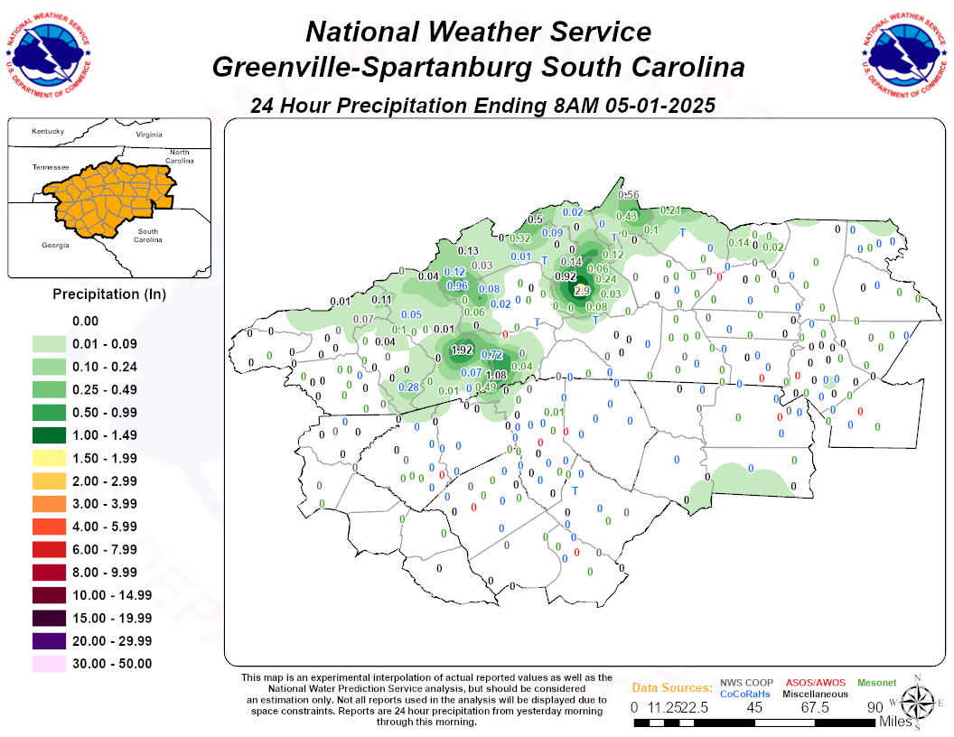
Edit to add these 24 hour totals from GSP as of 7am. Lots of street flooding in the upstate this am.


?Don’t look at CMC or GFS we should be in full SER flame mode during that time period as we’ve been promised.

Notice that also.Cmc is a really nice evolution for a winter storm. Also 180hr icon has a similar look.

No, this looks out to sea. There will not be any moisture thrown back that far inland with a low that far out. Looks like it will have to trend NW if we are going to get anything.NW trend should put this storm in... checks notes... Dubuque by day 10.
View attachment 129311


If we had this inside 36 hours it would still be extremely suspect. I think this pattern is priming for a big mid month Appalachian snow. Active southern stream with east coast ridging hanging around and marginal cold. This is when the big dogs like to eat.There is some mild ensemble support, esp on the CMCE, it’s nowhere near as weenie, but the pattern is very Miller B esque, weak SE Canada vortex, higher heights in between, southern stream wave. A basic CAD/Miller B look. need to trend to a stronger SE Canada vortex. Way to do that is slow down the pacific trough/build higher heights in central canada to encourage more northern stream digging, which is very much possible. The biggest problem i see here is, in this progressive pattern, there’s nothing to keep it in place, so this is something that would have to be perfect timing View attachment 129315View attachment 129316


