-
Hello, please take a minute to check out our awesome content, contributed by the wonderful members of our community. We hope you'll add your own thoughts and opinions by making a free account!
You are using an out of date browser. It may not display this or other websites correctly.
You should upgrade or use an alternative browser.
You should upgrade or use an alternative browser.
Pattern Jammin January 2023
- Thread starter Goose88
- Start date
Just saying, If we retract the pacific jet any, that warmth is gonna come to a end rather quick lol
packfan98
Moderator
I’ve been looking at the models and seeing not a terrible 5H pattern, but no cold air to work with. Where will the cold air come from?
iGRXY
Member
Whenever you doubt the wedge, you’re already losing. It’ll come. 70’s will quickly switch to 45 and rain in a blink of an eye. Happens too often(Mods change name when the time comes)
Yeah it’s not looking too good to start out the month. Gonna love the warm temps tho, can’t wedge when our wedge source region is burning on fire !!! View attachment 127457View attachment 127458View attachment 127459View attachment 127460View attachment 127461
It’s pacific polar derivedI’ve been looking at the models and seeing not a terrible 5H patte, but no cold air to work with. Where will the cold air come from?
Itryatgolf
Member
I think you meant extend unless this is a totally different situationJust saying, If we retract the pacific jet any, that warmth is gonna come to a end rather quick lol
Whenever you doubt the wedge, you’re already losing. It’ll come. 70’s will quickly switch to 45 and rain in a blink of an eye. Happens too often
Sorry but that’s not a wedge pattern, there’s no SE Canada vortex, but a SE Canada torch, maybe when the pattern initially switches, but mid on, no. there’s no high pressure feed from Alaska. the pacific trough doesn’t allow Arctic high pressure to enter Canada. It’s different when you have a -EPO/-WPO coupled to a -PNA, but Theres a +EPO/+WPO here with a -PNA. There’s literally no cold on our side of the globe with this look
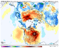
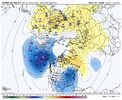
I think we’re burning through at least the first week of January. It does look like cold comes back after the first ten days of the month on the CFS. We’ll see, I guess.
No. We look to overextend the pacific jet due to much +EAMT, it’s a SPV slow killer, but we actually need the pacific jet to calm down via retraction or a weak -EAMT event, that way we back back the Alaskan low off and build heights our west/in western CanadaI think you meant extend unless this is a totally different situation
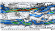
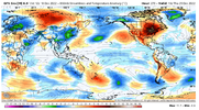
Itryatgolf
Member
Hopefully we can get what we need to get colder again in January thenNo. We look to overextend the pacific jet due to much +EAMT, it’s a SPV slow killer, but we actually need the pacific jet to calm down via retraction or a weak -EAMT event, that way we back back the Alaskan low off and build heights our west/in western Canada View attachment 127464View attachment 127465
It’s worth noting Those looks with Alaskan lows /-PNAs often mean robust severe weather events for the western Southeast since there’s nothing stopping return flow like high pressure in the NE, and AK vortexes favor cutoff lows
Good Ole JB said warm until around 10th then cold coming but who pays attention to him.
JHS
Member
We may have something in the Carolinas too if things go just right. Some models bring dewpoints up to the mid 60's east of the mountains in both states.It’s worth noting Those looks with Alaskan lows /-PNAs often mean robust severe weather events for the western Southeast since there’s nothing stopping return flow like high pressure in the NE, and AK vortexes favor cutoff lows
That’s basically what happened in January 2011. If you remember we had a pretty good warm up a few days after the Christmas storm and it was fairly mild going into the New Year before the pattern switched back to cold and we had that long tracked storm around the 10th. The good news is that both AO and NAO look to start dropping quickly negative again after spending a few days in neutral territory later next week. So it doesn’t look like the PV is gonna start getting really wound up anytime soon.No. We look to overextend the pacific jet due to much +EAMT, it’s a SPV slow killer, but we actually need the pacific jet to calm down via retraction or a weak -EAMT event, that way we back back the Alaskan low off and build heights our west/in western Canada View attachment 127464View attachment 127465
It very much could. La Niña years are know to screw up one of the winter months with SER and stale warm pacific air zonal crap. But it doesn’t stay like that forever so I’m glad we look to get it to start January when we then have great climo odds after for when the pattern wants to flip again.Damn I hope our coldest month doesn't torch
Honestly I’m fine to just scrub the pattern completely and start from scratch! Maybe get in a fun severe threat or two while we’re at it to keep things interesting.
I read recently that it looks like the ENSO will be in a neutral state by the time we get the February. Do you think that will have any effect on the back half of winter?It very much could. La Niña years are know to screw up one of the winter months with SER and stale warm pacific air zonal crap. But it doesn’t stay like that forever so I’m glad we look to get it to start January when we then have great climo odds after for when the pattern wants to flip again.
Honestly I’m fine to just scrub the pattern completely and start from scratch! Maybe get in a fun severe threat or two while we’re at it to keep things interesting.
It takes a little bit for large scale forcing to effect things downstream.. by the time we get to February we’re in the back half of things and would think if there is an enso shift it would effect things for the summer time and beyondI read recently that it looks like the ENSO will be in a neutral state by the time we get the February. Do you think that will have any effect on the back half of winter?

