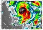
That eye wall is looking better and better.
-
Hello, please take a minute to check out our awesome content, contributed by the wonderful members of our community. We hope you'll add your own thoughts and opinions by making a free account!
You are using an out of date browser. It may not display this or other websites correctly.
You should upgrade or use an alternative browser.
You should upgrade or use an alternative browser.
Tropical Hurricane Idalia
- Thread starter $alt
- Start date
968 mb per NOAA dropshode.


Mesoscale models HRRR and WRF (00z run) picked up on it pretty well. Idk about recent runs this afternoon since I’ve been at work and trying to catch up.Yes… it definitely looks like a PRE developing. None of the models have really picked up on it which is fairly typical. It’ll be interesting to see how far north it moves… it’s got plenty of juicy air ahead of it.
Brent
Member
Pressure starting to really drop
966.1 mb per latest USAF pass.
000
URNT15 KNHC 292213
AF304 1110A IDALIA HDOB 23 20230829
220430 2626N 08438W 6967 02899 9680 +165 +121 124021 031 037 002 00
220500 2625N 08439W 6966 02896 9680 +163 +118 110010 016 024 001 00
220530 2623N 08440W 6973 02885 9682 +159 +120 293005 010 015 001 00
220600 2621N 08440W 6965 02891 9685 +153 +124 277017 020 021 000 00
220630 2620N 08440W 6974 02890 9699 +143 +136 279029 033 019 001 00
220700 2618N 08441W 6965 02905 9701 +149 +124 282035 036 /// /// 03
220730 2619N 08442W 6967 02905 9702 +151 +120 287028 033 /// /// 03
220800 2621N 08442W 6967 02894 9686 +154 +120 296023 026 021 001 03
220830 2622N 08441W 6963 02889 9669 +162 +117 292013 021 021 000 00
220900 2624N 08440W 6967 02878 9666 +160 +117 252003 008 019 001 00
220930 2626N 08440W 6969 02877 9662 +168 +109 099007 012 015 000 03
221000 2628N 08439W 6970 02879 9663 +168 +117 116020 024 014 000 00
221030 2628N 08438W 6961 02891 9661 +168 +106 123024 026 /// /// 03
221100 2626N 08438W 6968 02870 9661 +155 +128 125012 021 /// /// 03
221130 2625N 08439W 6965 02874 9661 +158 +125 296005 009 016 000 00
221200 2624N 08440W 6970 02877 9666 +161 +119 307015 020 019 001 00
221230 2623N 08442W 6967 02887 9672 +162 +119 307027 031 023 000 00
221300 2621N 08443W 6969 02895 9683 +163 +107 301033 035 027 001 00
221330 2620N 08444W 6963 02913 9708 +148 +124 301042 045 042 002 00
221400 2618N 08445W 6967 02926 9734 +140 //// 306060 063 063 002 05
$$
;
Stormsfury
Member
Concentric 12 and 20 NM Eyes...
Product: NOAA Vortex Message (URNT12 KWBC)
Transmitted: 29th day of the month at 22:11Z
Agency: National Oceanic and Atmospheric Administration (NOAA)
Aircraft: Lockheed WP-3D Orion (Reg. Num. N43RF)
Storm Name: Idalia
Storm Number & Year: 10 in 2023 (flight in the North Atlantic basin)
Mission Number: 12
Observation Number: 06 ( See all messages of this type for this mission. )
A. Time of Center Fix: 29th day of the month at 21:44:51Z
B. Center Fix Coordinates: 26.28N 84.74W
B. Center Fix Location: 180 statute miles (290 km) to the W (262°) from Fort Myers, FL, USA.
C. Minimum Height at Standard Level: Not Available
D. Minimum Sea Level Pressure: 968mb (28.59 inHg)
E. Dropsonde Surface Wind at Center: From 65° at 4kts (From the ENE at 5mph)
F. Eye Character: Ragged
G. Eye Shape: Concentric (has an inner and outer eye)
G. Inner Eye Diameter: 12 nautical miles (14 statute miles)
G. Outer Eye Diameter: 20 nautical miles (23 statute miles)
H. Estimated (by SFMR or visually) Maximum Surface Wind Inbound: 84kts (96.7mph)
I. Location & Time of the Estimated Maximum Surface Wind Inbound: 12 nautical miles (14 statute miles) to the E (99°) of center fix at 21:41:47Z
J. Maximum Flight Level Wind Inbound: From 181° at 103kts (From the S at 118.5mph)
K. Location & Time of the Maximum Flight Level Wind Inbound: 15 nautical miles (17 statute miles) to the E (95°) of center fix at 21:40:55Z
L. Estimated (by SFMR or visually) Maximum Surface Wind Outbound: 64kts (73.6mph)
M. Location & Time of the Estimated Maximum Surface Wind Outbound: 6 nautical miles to the WSW (244°) of center fix at 21:46:18Z
N. Maximum Flight Level Wind Outbound: From 313° at 64kts (From the NW at 73.6mph)
O. Location & Time of the Maximum Flight Level Wind Outbound: 10 nautical miles (12 statute miles) to the WSW (242°) of center fix at 21:47:27Z
P. Maximum Flight Level Temp & Pressure Altitude Outside Eye: 15°C (59°F) at a pressure alt. of 2,458m (8,064ft)
Q. Maximum Flight Level Temp & Pressure Altitude Inside Eye: 23°C (73°F) at a pressure alt. of 2,460m (8,071ft)
R. Dewpoint Temp (collected at same location as temp inside eye): 17°C (63°F)
R. Sea Surface Temp (collected at same location as temp inside eye): Not Available
S. Fix Determined By: Penetration, Radar, Wind and Pressure
S. Fix Level: Other - Not surface, 1500ft, 925mb, 850mb, 700mb, 500mb, 400mb, 300mb or 200mb
T. Navigational Fix Accuracy: 0.01 nautical miles
T. Meteorological Accuracy: 2 nautical miles
Remarks Section:
Maximum Flight Level Wind: 103kts (~ 118.5mph) which was observed 15 nautical miles (17 statute miles) to the E (95°) from the flight level center at 21:40:55Z
Brent
Member
Eyewall still needs work before it can truly bomb. Too ragged
chase5ash
Member
Potential micro analyzing, but seems like a pretty couple solid jogs to the East as of late
lexxnchloe
Member
Hopefully it runs out of time before it can get too strong. Luckily its not going 8mphEyewall still needs work before it can truly bomb. Too ragged
Henry2326
Member
5 pm NHC discussion:
■■■1. Catastrophic impacts from storm surge inundation of 10 to 15 feet above ground level and destructive waves are expected somewhere
■■■between Aucilla River and Yankeetown, Florida.
Life-threatening
storm surge inundation is likely elsewhere along portions of the
Florida Gulf Coast where a Storm Surge Warning is in effect.
Residents in these areas should follow any advice given by local
officials.
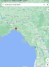
Between the red and blue points.....

Last edited:
NoSnowATL
Member
Looks like a waggle but close to a NNE look for sure. After looking at it more it def NNE. Looks like it has picked up the trough.Potential micro analyzing, but seems like a pretty couple solid jogs to the East as of late
Def pushing off to the East of 85W now. I think the Track looks spot on...

965 mb
NoSnowATL
Member
The good news with this one is a lot of the higher impact areas have relatively low populations. There isn’t a ton on the coast between north of Tampa and Tallahassee.
Henry2326
Member
Unfortunately a situation like Ian, brings them back in. And won't take much of a tweak. Like threading a needle....The good news with this one is a lot of the higher impact areas have relatively low populations. There isn’t a ton on the coast between north of Tampa and Tallahassee.
962.4 mb per USAF.
322
URNT15 KNHC 292343
AF304 1110A IDALIA HDOB 32 20230829
233430 2640N 08430W 6959 02940 //// +106 //// 237092 097 074 022 01
233500 2641N 08431W 6968 02915 //// +109 //// 234079 088 084 015 01
233530 2642N 08433W 6970 02895 //// +111 //// 234057 075 084 015 01
233600 2643N 08434W 6976 02875 9692 +127 //// 229047 048 065 006 01
233630 2644N 08435W 6958 02888 9683 +137 //// 230040 048 047 004 01
233700 2645N 08437W 6966 02865 9660 +147 +132 224035 038 040 002 00
233730 2647N 08438W 6963 02859 9639 +158 +125 223022 030 036 002 00
233800 2648N 08439W 6969 02847 9634 +158 +128 260011 018 028 001 00
233830 2650N 08440W 6975 02833 9624 +163 +134 334005 010 022 000 03
233900 2651N 08440W 6951 02864 9633 +155 +134 118011 018 022 000 00
233930 2653N 08439W 6966 02855 9647 +152 +124 140027 029 024 000 03
234000 2652N 08437W 6968 02851 9643 +153 +123 151027 029 /// /// 03
234030 2651N 08439W 6964 02843 9627 +155 +123 146011 025 019 001 00
234100 2650N 08441W 6970 02836 9632 +150 +137 337016 023 023 002 00
234130 2648N 08442W 6957 02860 9653 +138 //// 324035 048 028 002 01
234200 2646N 08442W 6969 02868 9670 +142 +141 303062 063 /// /// 03
234230 2645N 08440W 6967 02868 9673 +140 //// 283055 064 /// /// 05
234300 2646N 08438W 6958 02864 9659 +134 //// 259044 051 /// /// 05
234330 2648N 08437W 6970 02837 9637 +145 +141 228026 038 029 001 03
234400 2649N 08438W 6968 02836 9625 +156 +129 230012 021 028 002 00
$$
;
8:00 PM EDT Tue Aug 29
Location: 26.9°N 84.7°W
Moving: N at 16 mph
Min pressure: 965 mb
Max sustained: 105 mph

