• Hello, please take a minute to check out our awesome content, contributed by the wonderful members of our community. We hope you'll add your own thoughts and opinions by making a free account!

Tropical Hurricane Ian

I know I am one of the old dogs but damn, I miss John Hope this time of year.
That brings me back to yesteryear when the Weather Channel actually broadcasted the weather 24/7 at times other than special situations. John Hope was the best the Weather Channel ever had although Steve Lyons and Richard Knabb knew what they were doing too. It seemed like John Hope would insert the phrase "As time goes by" into every sentence.
 
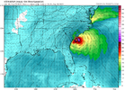
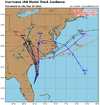
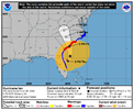
The 200-700Mb Level of the atmosphere is trying to steer the system to the NNE as the 700-850Mb steering slows or completely collapses after Cuba. I can't imagine Ian just heading north without wobbling to the East with a strong storm. I suspect horizontal sheer will also blow convection towards the NE side of the storm, and it already looks like it's having an impact on the NW side.

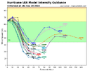
Also, This system is Definitely Rapidly Intensifying at the moment. I'd say the strength is accelerating ahead of model outputs.
 

Attachments

  • wg8dlm6.gif
    wg8dlm6.gif
    206.7 KB · Views: 27
  • wg8dlm2.gif
    wg8dlm2.gif
    195.4 KB · Views: 27
  • wg8dlm6.gif
    wg8dlm6.gif
    206.7 KB · Views: 27
Last edited:
The 200-700Mb Level of the atmosphere is trying to steer the system to the NNE as the 700-850Mb steering slows or completely collapses after Cuba. I can't imagine Ian just heading north without wobbling to the East with a strong storm. I suspect horizontal sheer will also blow convection towards the NE side of the storm, and it already looks like it's having an impact on the NW side.

Also, This system is Definitely Rapidly Intensifying at the moment. I'd say the strength is accelerating ahead of model outputs.
I agree
 
Back
Top