-
Hello, please take a minute to check out our awesome content, contributed by the wonderful members of our community. We hope you'll add your own thoughts and opinions by making a free account!
You are using an out of date browser. It may not display this or other websites correctly.
You should upgrade or use an alternative browser.
You should upgrade or use an alternative browser.
Tropical Hurricane Dorian
- Thread starter RBR71
- Start date
pcbjr
Member
https://www.star.nesdis.noaa.gov/GOES/sector_band.php?sat=G16§or=car&band=13&length=24
Those storms off of Tampa and those in SC cause a bit of head scratching ...
Those storms off of Tampa and those in SC cause a bit of head scratching ...
Thay would likely get some rain and wind back toward the Triangle.
dsaur
Member
In my world it's time for a nice walkin my world, we call that an Errata Sheet!
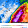
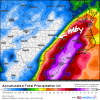
18z GFS was a Cape Fear special. Floyd on steroids basically
pcbjr
Member
You would be blessed ...
Yeah probably spells lights out for many SE of Raleigh, never really that fun in the summer. Lots of areas in that corner of the state have not recovered from Florence or Matthew for that matterYou would be blessed ...
Brent
Member
B
Brick Tamland
Guest
One thing for sure, the trend today has been moving more favorable for landfall versus going out to sea.
https://www.star.nesdis.noaa.gov/GOES/sector_band.php?sat=G16§or=car&band=13&length=24
Those storms off of Tampa and those in SC cause a bit of head scratching ...
I’m here in west Columbia got rough really fast. Heavy downpour and wind
JaxHurricane12
Member
Do y'all have the times for when the HWRF & HMON comes out?
pcbjr
Member
You can keep up with them here: https://www.tropicaltidbits.com/analysis/models/Do y'all have the times for when the HWRF & HMON comes out?
or in (y)our Wiki ...
HMON is running and the HWRF runs in 3 minutes.Do y'all have the times for when the HWRF & HMON comes out?
MichaelAndrews
Member
I’m here in Chapin and for a minute I was like what is he talking about?? Then I looked outside and went ohhhhhh hahaI’m here in west Columbia got rough really fast. Heavy downpour and wind
GeorgiaGirl
Member
https://www.star.nesdis.noaa.gov/GOES/sector_band.php?sat=G16§or=car&band=13&length=24
Those storms off of Tampa and those in SC cause a bit of head scratching ...
There was a 40% chance of showers I believe for the KCAE area and then to the east and south but the coverage and the kind of rain I'm getting at the moment sure seems like it should've been more like 60%.
I was a little surprised when I got a look at the southern SC radar after I heard the rain start too.
pcbjr
Member
look at their respective direction and flow ... Tampa and SC ...There was a 40% chance of showers I believe for the KCAE area and then to the east and south but the coverage and the kind of rain I'm getting at the moment sure seems like it should've been more like 60%.
I was a little surprised when I got a look at the southern SC radar after I heard the rain start too.
NoSnowATL
Member
A nice little wobble south again. Still moving west at 5ish.
Sent from my iPhone using Tapatalk
Sent from my iPhone using Tapatalk
Downeastnc
Member
GFS is pretty darn close last run to MBY I live in Simpson ( red circle) ....45-50 or so miles from the center as the crow flies though it is the weak side.....there is usually a wind maxima on the west side inland in the central coastal plains....GFS has the hurricane pretty weak though compared to ICON/Euro/Ukie


Holy Poop!
GeorgiaGirl
Member
hmm, yeah it looks like to me these storms in the southeast atm are tropical influenced. They're moving east to west. Interesting...
Courtesy of the WAR.hmm, yeah it looks like to me these storms in the southeast atm are tropical influenced. They're moving east to west. Interesting...
HWRF is 15mb lower at hour 15 than the 12z was at hour 21
HWRF is gonna be off if EWRC occurs. I think slight weakening but a bigger storm over the next 24-48
Recon getting into the storm now.
Ser Pounce
Member
Well crap, that's 4 years in a row now. Not sure when/if I'll go until there's more information.
pcbjr
Member
Recon may well say otherwise, but sat looks like due W atm
SUMMARY OF 700 PM EDT...2300 UTC...INFORMATION
----------------------------------------------
LOCATION...26.6N 77.6W
ABOUT 70 MI...110 KM E OF FREEPORT GRAND BAHAMA ISLAND
ABOUT 150 MI...240 KM E OF WEST PALM BEACH FLORIDA
MAXIMUM SUSTAINED WINDS...185 MPH...295 KM/H
PRESENT MOVEMENT...W OR 270 DEGREES AT 5 MPH...7 KM/H
MINIMUM CENTRAL PRESSURE...910 MB...26.88 INCHES
pcbjr
Member
ForsythSnow
Moderator
Yeah ERC is imminent. Fortunately, this is good news for the Bahamas, but bad news for Florida. It'll be complete sometime between tomorrow morning and tomorrow evening, still well away from landfall.
How can you tell?Yeah ERC is imminent. Fortunately, this is good news for the Bahamas, but bad news for Florida. It'll be complete sometime between tomorrow morning and tomorrow evening, still well away from landfall.
pcbjr
Member
LookHow can you tell?
Sorry - just had a major interruption at the front door ... did not mean to seem short ... went off before intended ...
Look at the eye; it seems to be "closing"; look at the bands around the eye --- seem to be increasing; watch how they interact and the outside moves in ... as time moves forward ...
ForsythSnow
Moderator
The microwave imagery and look at the recon data. See that sharp spike? It's the new eyewall developing fast.How can you tell?


