Henry2326
Member
Hmmm..it might just be dead on this time around...Not sure if I saw anyone post these and I know it has a west/southwest bias but here are the 12z UK ensembles View attachment 22785
Hmmm..it might just be dead on this time around...Not sure if I saw anyone post these and I know it has a west/southwest bias but here are the 12z UK ensembles View attachment 22785
right front quad is the bad ass
Not sure I understand ... 49ers? ... but I'm tired ...
no - NE quad ...The right front quad in this case would be the NW quadrant of the storm since it's moving towards the west.
no - NE quad ...
but it's gonna hockey puck due north ... or so "they" say ... just being forward looking ... LOLIt's the NE quad if the storm is moving in a northerly direction. In the case of a westward moving storm, the strongest winds would be on the NW quadrant of the storm since that would be the "front" of the storm. The winds on the NW side would get more speed added from the west forward motion of the storm.
but it's gonna hockey puck due north ... or so "they" say ... just being forward looking ... LOL
Simple way is to think "Front/Right"Quad of storm relative to the direction of travel/eyeIt's the NE quad if the storm is moving in a northerly direction. In the case of a westward moving storm, the strongest winds would be on the NW quadrant of the storm since that would be the "front" of the storm. The winds on the NW side would get more speed added from the west forward motion of the storm.
Simple way is to think "Front/Right"Quad of storm relative to the direction of travel/eye
I know (and knew) ... just tired and thought it was a nice bit of subtle humor ... guess not ... my bad ... carry on ...Simple way is to think "Front/Right"Quad of storm relative to the direction of travel/eye

.png")
Looks like Freeport now “should” miss the brunt of it..at least not due W
that could be trouble for all 4 SE states.18z nam is moving west of due north from 48-60 maybe even nnw. Heights are much higher to the east
Sent from my SM-G975U using Tapatalk
path of least resistance ...
Didn’t it passing to the south of Freeport portend more issues (and by issues here I mean potential disaster) for FL/GA/SC/NC? I know it’s not official, but I thought I remember earlier discussing this would be an indicator models may be somewhat awry.....Looks like Freeport now “should” miss the brunt of it..
The NAM is going to go OTS or scrape the outer banks. I think it's too far east.that could be trouble for all 4 SE states.
The 84 hr of Nam in my opinion is always wrong and will likely change.And....it turns northeast and misses SC....
Me too.....squeeze it up next to the coast or even on land and, as Phil says " it hockey pucks into Charleston or nearby....The NAM is going to go OTS or scrape the outer banks. I think it's too far east.
The hockey puck that concerns me is WPB to Orlando to Jax ... not in the cards this deal, but the Casino has a table open with a fresh deck ready to play ...Me too.....squeeze it up next to the coast or even on land and, as Phil says " it hockey pucks into Charleston or nearby....
It is astonishing to me how virtually all of these tracks (and most other guidance) parallel almost exactly the shape of the coast.
the damn thing is alive and has eyes and a brain ... it's a sci-fi movie in real life ...It is astonishing to me how virtually all of these tracks (and most other guidance) parallel almost exactly the shape of the coast.

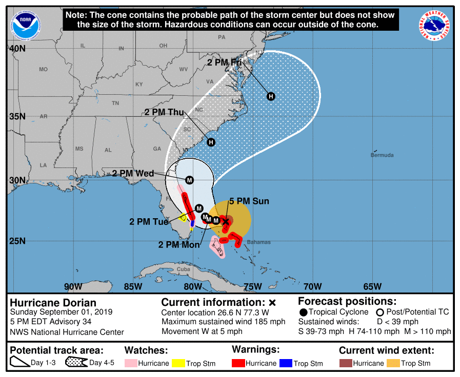
Hurricane Warnings issued for parts of the Florida coast.SUMMARY OF 500 PM EDT...2100 UTC...INFORMATION
----------------------------------------------
LOCATION...26.6N 77.3W
ABOUT 95 MI...150 KM E OF FREEPORT GRAND BAHAMA ISLAND
ABOUT 175 MI...280 KM E OF WEST PALM BEACH FLORIDA
MAXIMUM SUSTAINED WINDS...185 MPH...295 KM/H
PRESENT MOVEMENT...W OR 270 DEGREES AT 5 MPH...7 KM/H
MINIMUM CENTRAL PRESSURE...910 MB...26.88 INCHES
WATCHES AND WARNINGS
--------------------
CHANGES WITH THIS ADVISORY:
A Storm Surge Warning has been issued from Lantana to the
Volusia/Brevard County Line.
A Storm Surge Watch has been issued from the Volusia/Brevard County
Line to the Flagler/Volusia County Line.
A Hurricane Warning has been issued from Jupiter Inlet to the
Volusia/Brevard County Line.
A Hurricane Watch has been issued from the Volusia/Brevard County
Line to the Flagler/Volusia County Line
SUMMARY OF WATCHES AND WARNINGS IN EFFECT:
A Storm Surge Warning is in effect for...
* Lantana to the Volusia/Brevard County Line
A Storm Surge Watch is in effect for...
* North of Deerfield Beach to Lantana
* Volusia/Brevard County Line to the Flagler/Volusia County Line
A Hurricane Warning is in effect for...
* Northwestern Bahamas excluding Andros Island
* Jupiter Inlet to the Volusia/Brevard County Line
A Hurricane Watch is in effect for...
* Andros Island
* North of Deerfield Beach to Jupiter Inlet
* Volusia/Brevard County Line to the Flagler/Volusia County Line
A Tropical Storm Warning is in effect for...
* North of Deerfield Beach to Jupiter Inlet
A Tropical Storm Watch is in effect for...
* North of Golden Beach to Deerfield Beach
* Lake Okeechobee
A Storm Surge Warning means there is a danger of life-threatening
inundation, from rising water moving inland from the coastline,
during the next 36 hours in the indicated locations. For a
depiction of areas at risk, please see the National Weather
Service Storm Surge Watch/Warning Graphic, available at
hurricanes.gov. This is a life-threatening situation. Persons
located within these areas should take all necessary actions to
protect life and property from rising water and the potential for
other dangerous conditions. Promptly follow evacuation and other
instructions from local officials.
A Storm Surge Watch means there is a possibility of life-
threatening inundation, from rising water moving inland from the
coastline, in the indicated locations during the next 48 hours.
A Hurricane Warning means that hurricane conditions are expected
somewhere within the warning area. Preparations to protect life and
property should be rushed to completion.
A Hurricane Watch means that hurricane conditions are possible
within the watch area. A watch is typically issued 48 hours
before the anticipated first occurrence of tropical-storm-force
winds, conditions that make outside preparations difficult or
dangerous.
A Tropical Storm Warning means that tropical storm conditions are
expected within the warning area within 36 hours.
A Tropical Storm Watch means that tropical storm conditions are
possible within the watch area, generally within 48 hours.
Interests elsewhere along the east coast of Florida should continue
to monitor the progress of Dorian, as additional watches or
warnings may be required later today.
For storm information specific to your area in the United
States, including possible inland watches and warnings, please
monitor products issued by your local National Weather Service
forecast office. For storm information specific to your area
outside of the United States, please monitor products issued by
your national meteorological service.
It also got the pressure down to 898mb...3k is way close to FL
Sent from my SM-G975U using Tapatalk
Speed down to 5 mph now.
Land area is small and flat. I don't think it will have appreciable impacts. I think more impactful will be the negative attribute of upwelling as the stall occurs.Do we think it will weaken any since its heading over the Bahamas? Or is the land too small and flat?
Land area is small and flat. I don't think it will have appreciable impacts. I think more impactful will be the negative attribute of upwelling as the stall occurs.
What ERC's? This storm likes its eyewall too much to lose it.That or eyewall replacement cycles pretty much