Minimal unless it spends appreciable time out in the Atlantic. As long as it doesn't restrengthen, it will probably just be a bit breezy.@Rain Cold @Webberweather53 @SD Does anybody know what the impacts is regarding wind in Harnett County? I have PTSD over Florence, and this is shaping up to be a Florence.
-
Hello, please take a minute to check out our awesome content, contributed by the wonderful members of our community. We hope you'll add your own thoughts and opinions by making a free account!
You are using an out of date browser. It may not display this or other websites correctly.
You should upgrade or use an alternative browser.
You should upgrade or use an alternative browser.
Hurricane Debby
- Thread starter Brent
- Start date
accu35 gave some good advice. The local NWS offices usually issue storm briefings online and I expect that KRDU will be offering a briefing on Debby soon that will show possible impacts in more detail.@Rain Cold @Webberweather53 @SD Does anybody know what the impacts is regarding wind in Harnett County? I have PTSD over Florence, and this is shaping up to be a Florence.
Shaggy
Member
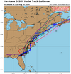
Icon track is right between euro and ukie so believable. Intensity is a joke though. It's trying to give a us a dgex moment for a hurricane wind forecast.
Drizzle Snizzle
Member
I’m not buying 2-4” of rain in Macon, GA. The way the radar looks they may not get anything.
Yeah I'd put wind 3rd in line right now as far as concern with flooding and tornadoes aheadMinimal unless it spends appreciable time out in the Atlantic. As long as it doesn't restrengthen, it will probably just be a bit breezy.
snowc
Member
Ok thank you. Sorry about that. I'm just very scared right now.This should probably go without saying, but please refrain from comments like "We're dead now" in this thread. You can always make nonsensical and OT comments in the banter thread. That's why we have that. Thanks very much.
snowc
Member
Where is the banter thread? I can't find it from the last time I visited.This should probably go without saying, but please refrain from comments like "We're dead now" in this thread. You can always make nonsensical and OT comments in the banter thread. That's why we have that. Thanks very much.
snowc
Member
Good thanks everyone for making my mind at ease.Yeah I'd put wind 3rd in line right now as far as concern with flooding and tornadoes ahead
Triplephase93
Member
Where is the banter thread? I can't find it from the last time I visited.
Misc - Sizzling Shenanigans: warm season whamby
Over just the last 3 weeks in my house, I’ve experienced these firsts: 88 humid degrees from a couple day long AC outage, a garage flood from very heavy Debby rains, and now a yellow jacket of all things. I hardly ever see yellow jackets outside much less getting inside. I’ve seen the bigger...
southernwx.com
Assuming the models that aren't the gfs are right it's going to be interesting to see how quickly the precip shield becomes left of track
Shaggy
Member
You can add icon and ukie to that euro camp as well
Yep. I wouldn't be surprised to see the higher totals expanding into the western Piedmont, assuming the track is represented correctly.Assuming the models that aren't the gfs are right it's going to be interesting to see how quickly the precip shield becomes left of track
Nerman
Member
Look for wrap around bands tonight. They could dump a lot quicklyI’m not buying 2-4” of rain in Macon, GA. The way the radar looks they may not get anything.
Definitely agree with the wind threat being secondary to flooding, but don't let your guard down on that if you happen to be in a flood-prone location. The high end flooding potential (i.e. worst case scenario) could be severe. Not trying to scare anyone, just know your area!Good thanks everyone for making my mind at ease.
Downeastnc
Member
Definitely agree with the wind threat being secondary to flooding, but don't let your guard down on that if you happen to be in a flood-prone location. The high end flooding potential (i.e. worst case scenario) could be severe. Not trying to scare anyone, just know your area!
The scary part is some of the river basins for the eastern rivers look to get 5-10" at least over pretty much the entire basin...that's fairly rare. I could see moderate or major flood stages for the Tar and Neuse and thier feeder creeks.
Stormsfury
Member
Mesovorticity embedded within the NE quadrant... actually saved that loop when I saw it earlier.
The scary part is some of the river basins for the eastern rivers look to get 5-10" at least over pretty much the entire basin...that's fairly rate. I could see moderate or major flood stages for the Tar and Neuse amd thier feeder creeks.
Right now I'd put the Pee Dee, Lumber and Cape Fear at the highest risk for sig flooding, a lot will depend on how much falls and where. Canadian would be about worst case scenario for the Cape Fear in that heaviest amounts are way upstream near the headwaters, add in 5-10' for the lower basin and that's a very large slug of water still needing to come downstream. You would probably need to go back to Florence and/or Matthew for the last time these rivers saw levels similar to what they are about to see in the coming weeks.
Henry2326
Member
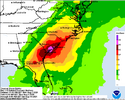
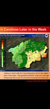
I wonder why the WPC and the local NWS vary so much? The WPC must be taking an average which includes the GFS which is likely wrong. Like I said yesterday a line from Greenwood to Union to Gastonia and east get big rain. Less than an inch west of there.Brad P’s rain call for now!View attachment 149472
6z AI euro stayed consistent with its track. I keep bringing it up because the track is actually a solid compromise between the gfs and the other models and it hasn't wavered since Saturday now the 12z UK has jumped into a similar track. Obviously a model can be consistently wrong but it's worth watching
Drizzle Snizzle
Member
Wow the models were way off in Georgia unless the precip builds back westward. I don't think Albany has had much of anything and they were forecast to get 3-4". Almost all the precip is east of I-75.
Very much agreed. We always see models greatly underestimate how far west the rain goes.Yep. I wouldn't be surprised to see the higher totals expanding into the western Piedmont, assuming the track is represented correctly.
I don’t think the WPC is taking the GFS to account in their forecast… I read their discussion earlier and it pretty much discounted it. I’m not sure I can recall seeing that much of disparity between the WPC and GSP’s maps.I wonder why the WPC and the local NWS vary so much? The WPC must be taking an average which includes the GFS which is likely wrong. Like I said yesterday a line from Greenwood to Union to Gastonia and east get big rain. Less than an inch west of there.
View attachment 149489
snowc
Member
Oh, i thought the whamby thread was separate from the banter thread. Thanks!Misc - Sizzling Shenanigans: warm season whamby
Over just the last 3 weeks in my house, I’ve experienced these firsts: 88 humid degrees from a couple day long AC outage, a garage flood from very heavy Debby rains, and now a yellow jacket of all things. I hardly ever see yellow jackets outside much less getting inside. I’ve seen the bigger...southernwx.com
Drizzle Snizzle
Member
The sun is out here lol. No rain so far and a gust maybe of 10mph. They cancelled school for this ?
lexxnchloe
Member
Where in GA?The sun is out here lol. No rain so far and a gust maybe of 10mph. They cancelled school for this ?
Drizzle Snizzle
Member
I am in Southwest Georgia (Americus). It's turning out to be a beautiful day here with a nice little breeze.Where in GA?
lexxnchloe
Member
Yea thats ridiculous and overkill to close anything there.I am in Southwest Georgia (Americus). It's turning out to be a beautiful day here with a nice little breeze.
12z euro is close to the 0z center at 90 hrs is along the nc/sc border between Marlboro and Scotland county
SC landfall was around garden city beach, murrels inlet
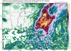
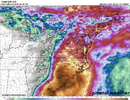
Total precip through 102 below. It flips to a LOT precip signature once inland so the heaviest rain is the US1 corridor from CAE to around sanford and west
SC landfall was around garden city beach, murrels inlet
Total precip through 102 below. It flips to a LOT precip signature once inland so the heaviest rain is the US1 corridor from CAE to around sanford and west

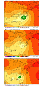
It would increase the wind threat in a box from RDU to CAE to CHS to Morehead city where it has sustained winds of 20-30kt so these areas are probably gusting 25-40kt
HugeSnowStick
Member
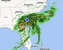
Some feeder bands are setting up east of ATL Metro, flying to the WNW.
This thing keeps moving short term at this rate,its gonna get back out over water a lot sooner than originally thought. So to me thats the question when an exactly where it hits the stall. Netting 8 miles an hour, so thats 172 miles in 24 hours, which will get it back over water tonight
Downeastnc
Member
This thing keeps moving short term at this rate,its gonna get back out over water a lot sooner than originally thought. So to me thats the question when an exactly where it hits the stall. Netting 8 miles an hour, so thats 172 miles in 24 hours, which will get it back over water tonight
Yeah it's hard to tell but seems like a lot of east component to it since landfall, official NHC track brings it back out over the Atlantic around the SC/GA border in roughly 24 hrs. It's definitely on the southern edge of the cone from last night.
The center is only 90ish miles from Jacksonville..and should be back over water around the FL/GA border sometime tonight if it kept this course.
coldfront22
Member
What are we thinking for Wilmington? 10-12 inches, possible more?
Euro wind maps seem to always be overdone inland.Euro keeps showing 10m winds gusting as high well inland as they do at the beaches when it comes ashore again.

