WRAL calling for 4 to 10 inches of rain locally from Debby and 30 to 45 mph gusts Friday.
-
Hello, please take a minute to check out our awesome content, contributed by the wonderful members of our community. We hope you'll add your own thoughts and opinions by making a free account!
You are using an out of date browser. It may not display this or other websites correctly.
You should upgrade or use an alternative browser.
You should upgrade or use an alternative browser.
Hurricane Debby
- Thread starter Brent
- Start date
I think a drop to 980-985mb is certainly possible, depending how long it has over water. The problem is that even a high end category 1 strengthening up to landfall and hitting the coast at a right angle can still cause a significant storm surge, especially with the beaches taking a pounding from rough surf the next couple days.992 it looks like.
Shaggy
Member
Holden beach is already damaged at the point on the east endI think a drop to 980-985mb is certainly possible, depending how long it has over water. The problem is that even a high end category 1 strengthening up to landfall and hitting the coast at a right angle can still cause a significant storm surge, especially with the beaches taking a pounding from rough surf the next couple days.
.jpg")

Yeah and it’s gonna be a stiff on shore wind for several daysHolden beach is already damaged at the point on the east end View attachment 149506View attachment 149507
GeorgiaGirl
Member
Kind of grateful for Debby a little bit because this has currently been blocking your typical summer heat. It's been nice outside.
The rain forecasted off the stall though...yikes.
The rain forecasted off the stall though...yikes.
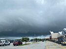
What a mess here! There had been a tornado warning that expired an hour ago. Much of the yard and entire patio is covered with standing water. Street flooded. Now this and there’s a very long ways to go before the on and off heavy rain ends. And the strong winds haven’t even got here yet though they’re now picking up. Also Tornado watch extended til 1AM:
THE NATIONAL WEATHER SERVICE IN CHARLESTON HAS ISSUED A
* FLASH FLOOD WARNING FOR...
BRYAN COUNTY IN SOUTHEASTERN GEORGIA...
BULLOCH COUNTY IN SOUTHEASTERN GEORGIA...
CHATHAM COUNTY IN SOUTHEASTERN GEORGIA...
EFFINGHAM COUNTY IN SOUTHEASTERN GEORGIA...
EVANS COUNTY IN SOUTHEASTERN GEORGIA...
LIBERTY COUNTY IN SOUTHEASTERN GEORGIA...
LONG COUNTY IN SOUTHEASTERN GEORGIA...
MCINTOSH COUNTY IN SOUTHEASTERN GEORGIA...
TATTNALL COUNTY IN SOUTHEASTERN GEORGIA...
JASPER COUNTY IN SOUTHEASTERN SOUTH CAROLINA...
* UNTIL 1130 PM EDT.
* AT 532 PM EDT, DOPPLER RADAR INDICATED BANDS OF TORRENTIAL RAIN
ASSOCIATED WITH TROPICAL STORM DEBBY WILL EXPAND ACROSS MUCH OF
SOUTHEAST GEORGIA THROUGH THE EVENING HOURS. BETWEEN 2.5 AND 5
INCHES OF RAIN HAVE FALLEN SO FAR THIS AFTERNOON. ADDITIONAL
RAINFALL AMOUNTS OF 4 TO 6 INCHES, WITH LOCALLY HIGHER AMOUNTS,
ARE POSSIBLE IN THE WARNED AREA. FLASH FLOODING IS EXPECTED TO
DEVELOP THIS EVENING AND COULD CONTINUE INTO THE OVERNIGHT HOURS.
HAZARD...LIFE THREATENING FLASH FLOODING. HEAVY RAIN PRODUCING
FLASH FLOODING.
SOURCE...RADAR INDICATED.
IMPACT...LIFE THREATENING FLASH FLOODING OF CREEKS AND STREAMS,
URBAN AREAS, HIGHWAYS, STREETS AND UNDERPASSES.
* SOME LOCATIONS THAT WILL EXPERIENCE FLASH FLOODING INCLUDE...
HINESVILLE, SAVANNAH, POOLER, BLUFFTON, RICHMOND HILL, REIDSVILLE,
GLENNVILLE, TYBEE ISLAND, CLAXTON, PEMBROKE AND DARIEN.
- Joined
- Jan 23, 2021
- Messages
- 4,604
- Reaction score
- 15,202
- Location
- Lebanon Township, Durham County NC
Beginning to wonder if that little high in the NE could increase the gradient
Debby is a moving..almost as if it wants to jump into the Atlantic as soon as possible. Very interesting on radar.
The 18z GFS is sticking to its guns. It’s either going to make the other modeling look rediculous or it’s going to have one the worst performances we have ever seen from a model in the mid range.
JHS
Member
It is actually west, and the center may just get back to Alabama again.The 18z GFS is sticking to its guns. It’s either going to make the other modeling look rediculous or it’s going to have one the worst performances we have ever seen from a model in the mid range.
D
Deleted member 609
Guest
Hope the 850s cooperate

lexxnchloe
Member
I was just going to say that. Its going rot over land a very long time before it ever gets here. Nothing burger here and it doesnt get back over water long enough to do much windwiseIt is actually west, and the center may just get back to Alabama again.
JHS
Member
I think it is just going to die out between Macon and Atlanta on this run.
Made almost to the GA/AL line before turning NNE. The center is just south of ATL on Friday evening. I mean this isn’t just the GFS doing goofy things like it does in the long range. This is literally getting into the time period that it’s most useful.It is actually west, and the center may just get back to Alabama again.
Edit: Even its rainfall totals are off for the set up. By 12z Saturday, there’s only 1-2 inches of rainfall for the NC mountains, despite days of a moist southeast flow running up the mountains.
lexxnchloe
Member
Way sw of 12Z. This is going to be like the relative who comes to visit and turns into a rotting fishI think it is just going to die out between Macon and Atlanta on this run.

On the plus side a nice fall like high will end summer for awhile

Observation vs science, but the trough to the west in the Carolinas (piedmont) and easterly wind fetch, plus a loop back west should be the focus here? For some reason this screams over-performer piedmont west. Even back to the south facing mtns (upslope).
JHS
Member
It goes poof over GA at hour 117, but is still dropping rain over a large area.
Shaggy
Member
Wilmington is not being shy about this risk.
&&
.SHORT TERM /TUESDAY NIGHT THROUGH WEDNESDAY NIGHT/...
Well into the thick of Debby at this point. Constant rain this
period, expected to be extremely heavy most of the time, as deep
Atlantic moisture gets pulled in from Debby spinning just offshore
of South Carolina. This deep moisture, combined with the slow
motion, will yield a widespread flooding rain threat. Flash flooding
is projected to be extreme in some cases, with rainfall amounts of
16-20 inches possible near the coast (8-16 inches possible inland).
If a particular rain band sets up just right, rainfall amounts could
easily exceed these numbers.
Several areas are likely to see road scours, washouts, and/or
complete failures. Flooding into structures in the low-lying areas
are a given. Flood waters are likely to cut some areas off from the
mainland. Over the last day or two, we`ve been using words like
"devastating," "catastrophic," and "life-threatening". These
words still apply. This is an issue everywhere, but especially
for the northeast SC coast. DO NOT drive across flooded areas.
Past events of this caliber have led to flash flood-related
fatalities, mostly because of people driving through flooded
roads. Please don`t do this.
We`ve gotten a lot of calls asking for comparisons of Debby vs.
other storms of the past. It`s not really appropriate to play the
comparison game, because Debby will be historic in its own right.
There is no way for us to know if you and your home will
specifically be part of that negative history. But what we CAN say
is that many lives and homes alike will be upended by this storm.
These kind of widespread impacts we haven`t seen in at least 5
years. PLEASE prepare now. Have fresh water, non-perishable foods,
batteries, meds, and more at the ready. Charge all of your devices.
See ready.gov/hurricanes for more information on what to include. Go
to weather.gov/media/ilm/LatestBriefing.pdf for our latest forecast,
which goes into better detail than what these forecast discussions
give
Holden beach is already damaged at the point on the east end View attachment 149506View attachment 149507
A Childs folly..
funny that (they) just spent several Million(s) on beach renourishment & sand dune rebuilding)

NOTICE the sediment (Layer), the top was just "laid" ,, renourished this past spring..
We ARE a society that believes that if we throw enough money at a problem that we can fix it.... climate, housing, education, medical, et al...
Sand Castels on shifting sands..
Stormsfury
Member
I've been monitoring the radars from KCHS and your suspicions are correct, in the last few hours, Savannah has radar estimates of 6" just in the last couple hours. Bands keep filling in from the dry slot merging into the PRE.New tornado warning from Doppler indicated circ nearing Vernonburg moving NW toward southside of SAV. Rains torrential! Likely have already had >6”!
Gas stations are going under water. Hope everyone got gas early.
lexxnchloe
Member
If the euro and ICON are right this makes sense, if the GFS and 18Z models are right not so much. Wish i could see 48 hours in the future and know where it will be then.Wilmington is not being shy about this risk.
&&
.SHORT TERM /TUESDAY NIGHT THROUGH WEDNESDAY NIGHT/...
Well into the thick of Debby at this point. Constant rain this
period, expected to be extremely heavy most of the time, as deep
Atlantic moisture gets pulled in from Debby spinning just offshore
of South Carolina. This deep moisture, combined with the slow
motion, will yield a widespread flooding rain threat. Flash flooding
is projected to be extreme in some cases, with rainfall amounts of
16-20 inches possible near the coast (8-16 inches possible inland).
If a particular rain band sets up just right, rainfall amounts could
easily exceed these numbers.
Several areas are likely to see road scours, washouts, and/or
complete failures. Flooding into structures in the low-lying areas
are a given. Flood waters are likely to cut some areas off from the
mainland. Over the last day or two, we`ve been using words like
"devastating," "catastrophic," and "life-threatening". These
words still apply. This is an issue everywhere, but especially
for the northeast SC coast. DO NOT drive across flooded areas.
Past events of this caliber have led to flash flood-related
fatalities, mostly because of people driving through flooded
roads. Please don`t do this.
We`ve gotten a lot of calls asking for comparisons of Debby vs.
other storms of the past. It`s not really appropriate to play the
comparison game, because Debby will be historic in its own right.
There is no way for us to know if you and your home will
specifically be part of that negative history. But what we CAN say
is that many lives and homes alike will be upended by this storm.
These kind of widespread impacts we haven`t seen in at least 5
years. PLEASE prepare now. Have fresh water, non-perishable foods,
batteries, meds, and more at the ready. Charge all of your devices.
See ready.gov/hurricanes for more information on what to include. Go
to weather.gov/media/ilm/LatestBriefing.pdf for our latest forecast,
which goes into better detail than what these forecast discussions
give
Crazy extreme on Highway 16 from nada in Macon to catastrophic storm unfolding for Savannah. This will likely be the same for areas further north into North Carolina.
Upgraded to a high flood risk for here Thursday.

Henry2326
Member
Just eye balling it here Deb looks like she’s gonna be off the coast of Georgia in about 4 or 5 hours
State of Emergency declared for North Carolina
lexxnchloe
Member
The whole state?State of Emergency declared for North Carolina
LickWx
Member
Toss, flood risk is not extreme and only high. Boo. Bring me biblical floods. Jk. Rip lumberton
Downeastnc
Member
Just eye balling it here Deb looks like she’s gonna be off the coast of Georgia in about 4 or 5 hours
The eastern remnant eyewall structure is only 20 miles or so from being over ocean and the center 40 or so...well at least the eastern side of the old center...
Has been on the very eastern edge of the cone all day. The NHC has the center moving offshore tomorrow near Savannah...
If they’re giving the GFS the same weight as other field offices in the region and the WPC are, they are completely dismissing it.If the euro and ICON are right this makes sense, if the GFS and 18Z models are right not so much. Wish i could see 48 hours in the future and know where it will be then.
Pretty massive QPF through 48 hours on 18z HRRR. Lot of rain still to go after this.

It also indicates a large swath of 1-2"hr bands ongoing.

Major flooding is imminent across eastern GA / eastern SC / and much of central and eastern NC.
It also indicates a large swath of 1-2"hr bands ongoing.
Major flooding is imminent across eastern GA / eastern SC / and much of central and eastern NC.

Triplephase93
Member
From ~30 minutes ago, the street and sidewalks are covered by a river (back lawn has more standing water):
View attachment 149516
Keep the updates and pics coming.
lexxnchloe
Member
The eastern remnant eyewall structure is only 20 miles or so from being over ocean and the center 40 or so...well at least the eastern side of the old center...
Has been on the very eastern edge of the cone all day. The NHC has the center moving offshore tomorrow near Savannah...
Stormsfury
Member
It's a little more than that on the Valdosta radar, but the structure on the Eastern side is holding up extremely well. That Eastern side dumped 15" of rain in a very short time earlier today just after landfall..The eastern remnant eyewall structure is only 20 miles or so from being over ocean and the center 40 or so...well at least the eastern side of the old center...
Has been on the very eastern edge of the cone all day. The NHC has the center moving offshore tomorrow near Savannah...

Shaggy
Member
My question is as that very solid eastern core should be over water soon if it helps tug the center with it and gets it offshore fasterIt's a little more than that on the Valdosta radar, but the structure on the Eastern side is holding up extremely well. That Eastern side dumped 15" of rain in a very short time earlier today just after landfall..
View attachment 149517
I was looking at the model runs and the ICON has Debby as a 964mb hurricane off of Myrtle Beach before making landfall again. That would be a Cat 3 hurricane if that were to verify. Let's hope its out in left field with its estimate of storm strength.