Those maps are almost always over done. Winds will not be an issue, especially inlandEuro keeps showing 10m winds gusting as high well inland as they do at the beaches when it comes ashore again.
-
Hello, please take a minute to check out our awesome content, contributed by the wonderful members of our community. We hope you'll add your own thoughts and opinions by making a free account!
You are using an out of date browser. It may not display this or other websites correctly.
You should upgrade or use an alternative browser.
You should upgrade or use an alternative browser.
Hurricane Debby
- Thread starter Brent
- Start date
ENCSnowdawg
Member

- Joined
- Jan 23, 2021
- Messages
- 4,604
- Reaction score
- 15,202
- Location
- Lebanon Township, Durham County NC
and I would assume something moving as slow as this seems to be moving would dissipate them even moreThose maps are almost always over done. Winds will not be an issue, especially inland
Blue_Ridge_Escarpment
Member
Wow that’s a big jump west at this lead time. Wonder what caused all of the models at 18Z to do that?
ENCSnowdawg
Member
Attachments
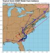
Wait, what? Now this means the track is shifting toward Charlotte?

- Joined
- Jan 5, 2017
- Messages
- 3,803
- Reaction score
- 6,053
Those showers are moving west southwest and will not likely move much further north as the entire system is slowly moving off to the east northeast. Atlanta should stay fairly dry as well as many points west and southwest of the city. Some light rain accumulations between McDonough and Macon appear possible.Some feeder bands are setting up east of ATL Metro, flying to the WNW.
IMO they’re really just starting to zero in on the EURO’s idea the last couple days of a landfall near or just south of Myrtle Beach. The big change on this is what happens after landfall and how soon it makes a north and eventual northeast turn. Many of those plots keep a NW or even WNW motion longer. The UKMET for instance now brings the center back to CLT before making the turn. I haven’t seen any of the 12z EURO because it’s not up on TT yet, but it will be interesting to see if it follows the UKMET on that idea. If it does then that set the stage for extreme rainfall totals all the back to the mountainsWow that’s a big jump west at this lead time. Wonder what caused all of the models at 18Z to do that?
Right. You can even look at the current obs across inland southern GA and FL, winds are generally gusting in the 30s with a few gusts to around 40 scattered here and there. Power outage numbers are surprisingly high though, so that is interestingand I would assume something moving as slow as this seems to be moving would dissipate them even more
iGRXY
Member
Was about to say the same thing. If you get that track which is what I've been calling for which is Charleston to Camden to Monroe (that's actually a lot of more westerly solutions) we will get bigger rains back this way. If you get this to pass by Charlotte we definitely will.Wow that’s a big jump west at this lead time. Wonder what caused all of the models at 18Z to do that?
I have a cousin that lives in Valdosta and she has been without power since late yesterday evening. The highest wind gust they’ve had has been 48mph but she says it’s been a steady wind since yesterday evening. I’m guessing the ground is very saturated which means the winds don’t have to be too high to start knocking down trees….something to keep in mind for the eastern Carolinas later this weekRight. You can even look at the current obs across inland southern GA and FL, winds are generally gusting in the 30s with a few gusts to around 40 scattered here and there. Power outage numbers are surprisingly high though, so that is interesting
The 5:00 PM advisory from the National Weather Service will be interesting. I wonder if they will buy into the shift westward that the 18Z model runs are showing.
iGRXY
Member
Take it for what its worth but the UKIE and Euro AI are showing a swath of 2-5" and follow the most recent spaghetti models of landfall between Charleston and Myrtle beach and track WNW. Combine that with the stalled front and some higher than expected totals start to make sense. Highest will be Newberry to Union to Gaffney east where I think 4-7" is likely.I wonder why the WPC and the local NWS vary so much? The WPC must be taking an average which includes the GFS which is likely wrong. Like I said yesterday a line from Greenwood to Union to Gastonia and east get big rain. Less than an inch west of there.
View attachment 149489
lexxnchloe
Member
If it goes in that far south and heads that far west as the 18Z models show then i dont think wind will be an issue in SE NCI have a cousin that lives in Valdosta and she has been without power since late yesterday evening. The highest wind gust they’ve had has been 48mph but she says it’s been a steady wind since yesterday evening. I’m guessing the ground is very saturated which means the winds don’t have to be too high to start knocking down trees….something to keep in mind for the eastern Carolinas later this week
Euro is garden city beach to dillon to sanford to maybe south hillIMO they’re really just starting to zero in on the EURO’s idea the last couple days of a landfall near or just south of Myrtle Beach. The big change on this is what happens after landfall and how soon it makes a north and eventual northeast turn. Many of those plots keep a NW or even WNW motion longer. The UKMET for instance now brings the center back to CLT before making the turn. I haven’t seen any of the 12z EURO because it’s not up on TT yet, but it will be interesting to see if it follows the UKMET on that idea. If it does then that set the stage for extreme rainfall totals all the back to the mountains
And just a psa for everyone it starts running on pivotal around 130-145
Thanks. For some reason the EURO has been lagging behind on TT the last couple days.Euro is garden city beach to dillon to sanford to maybe south hill
And just a psa for everyone it starts running on pivotal around 130-145
JHS
Member
Yeah, the Euro AI dumps over all but the far western parts of both states and if the center comes back to I-77, the upslope area of the NC foothills may have a problem. The regular Euro keeps the rain mostly east of 321, but a small shift would change things.Take it for what its worth but the UKIE and Euro AI are showing a swath of 2-5" and follow the most recent spaghetti models of landfall between Charleston and Myrtle beach and track WNW. Combine that with the stalled front and some higher than expected totals start to make sense. Highest will be Newberry to Union to Gaffney east where I think 4-7" is likely.
Was wondering if this was due to front interaction on the front side of the storm.Those maps are almost always over done. Winds will not be an issue, especially inland
ENCSnowdawg
Member
IMO they’re really just starting to zero in on the EURO’s idea the last couple days of a landfall near or just south of Myrtle Beach. The big change on this is what happens after landfall and how soon it makes a north and eventual northeast turn. Many of those plots keep a NW or even WNW motion longer. The UKMET for instance now brings the center back to CLT before making the turn. I haven’t seen any of the 12z EURO because it’s not up on TT yet, but it will be interesting to see if it follows the UKMET on that idea. If it does then that set the stage for extreme rainfall totals all the back to the mountains
Attachments
983 was euro 12z pressure at LF.
Heres 12z Ukie qpf

Heres 12z Ukie qpf
I doubt they make any big changes. The factors that really push and pull this to the east then west track are still over the upper Midwest, canada, and out near bermuda. The only good thing about the slow motion is there's some time to adjust to a dramatic shiftThe 5:00 PM advisory from the National Weather Service will be interesting. I wonder if they will buy into the shift westward that the 18Z model runs are showing.
Thats najor river flooding Pee Dee and Cape Fear River Basins that will come down to already Flooded NE SC and SE NC. Per 12z Ukie,if verefied
lexxnchloe
Member
Thanks. For some reason the EURO has been lagging behind on TT the last couple days.

Just looking at it myself. Not as far back west as the UKMET but a tick back to the west. It really seems to be holding firm on a landfall just south of Myrtle Beach
Downeastnc
Member
Was just looking at the vis loop and thinking her overall appearance has improved since landfall...
severestorm
Member
chuckhendo
Member
Was just looking at the vis loop and thinking her overall appearance has improved since landfall...
It's actually not looking too shabby on radar either considering how long it's been over land
Dr Knab onTWC just said isolated spots in SC, WILL see 20-30” of rain!
It’s bad here in Chatham. Tornado sirens are out but can’t chase anything due to flooding and can’t see anything
Tornado warning out for Savanah.

Henry2326
Member
Hmmmm....this is not a good change.
5:00 discussion.....
The tropical cyclone should continue to weaken while it moves over
land for the next day or so. By late Tuesday, assuming the center
of the system moves back over water, some re-intensification is
forecast. The NHC forecast continues to show only modest
restrengthening due to the uncertainties, although this may be
conservative.
iGRXY
Member
Already getting some feeder showers coming through here
Wonder if we will have to worry about tornadoes up here when she gets closer.
At hour 63, the ICON has bended back to the NW and is about to make landfall near Murrel’s Inlet/Garden City. Basically where the UKMET and EURO were. It’s still dropping pressure down to 965mb which just seems way too low.
YesWonder if we will have to worry about tornadoes up here when she gets closer.
JHS
Member
Also, the Euro AI is not backing down at all and has the center all the way back to Chester County in SC at hour 84.At hour 63, the ICON has bended back to the NW and is about to make landfall near Murrel’s Inlet/Garden City. Basically where the UKMET and EURO were. It’s still dropping pressure down to 965mb which just seems way too low.
The ICON through hour 90 basically ended up following the 12z EURO so it’s another tick west after landfall. Just out of curiosity, how low does the EURO AI drop the pressure to?Also, the Euro AI is not backing down at all and has the center all the way back to Chester County in SC at hour 84.
JHS
Member
The ICON has come west about 30-40 miles in NC and is slower.
JHS
Member
992 it looks like.The ICON through hour 90 basically ended up following the 12z EURO so it’s another tick west after landfall. Just out of curiosity, how low does the EURO AI drop the pressure to?
It’s easy to see why these models are ticking back west with the inland track…they’re centering a high pressure just off the New England coast.The ICON has come west about 30-40 miles in NC and is slower.