Belle Lechat
Member
- Joined
- Aug 29, 2021
- Messages
- 1,547
- Reaction score
- 1,224
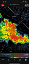
748 AM EDT FRI AUG 9 2024
THE NATIONAL WEATHER SERVICE IN STERLING VIRGINIA HAS ISSUED A
* TORNADO WARNING FOR...
SOUTHWESTERN PRINCE GEORGES COUNTY IN CENTRAL MARYLAND...
NORTH CENTRAL CHARLES COUNTY IN SOUTHERN MARYLAND...
SOUTHEASTERN FAIRFAX COUNTY IN NORTHERN VIRGINIA...
* UNTIL 815 AM EDT.
* AT 748 AM EDT, A SEVERE THUNDERSTORM CAPABLE OF PRODUCING A TORNADO
WAS LOCATED 7 MILES NORTHWEST OF LA PLATA, MOVING NORTH AT 40 MPH.
HAZARD...TORNADO.
SOURCE...RADAR INDICATED ROTATION.
* THIS DANGEROUS STORM WILL BE NEAR...
FORT WASHINGTON, FORT HUNT, GROVETON, FORT BELVOIR, AND HYBLA
VALLEY AROUND 755 AM EDT.
OTHER LOCATIONS IMPACTED BY THIS TORNADIC THUNDERSTORM INCLUDE BRYANS
ROAD, MOUNT VERNON, HAYFIELD, POTOMAC HEIGHTS, AND ACCOKEEK.