-
Hello, please take a minute to check out our awesome content, contributed by the wonderful members of our community. We hope you'll add your own thoughts and opinions by making a free account!
You are using an out of date browser. It may not display this or other websites correctly.
You should upgrade or use an alternative browser.
You should upgrade or use an alternative browser.
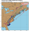
Hurricane Debby
- Thread starter Brent
- Start date

Believe it or not, the 0Z GFS is the 12th in a row that is coming back W into GA on THU AM! Also, after yesterday’s 6Z GEFS was the first run in days to have more members finally getting away from that kind of thing, the last 3 runs have come back S again.
The GFS suite actually has had a little bit of company since 12Z today: the 12Z JMA and now 0Z JMA are also stalling and then coming W into lower SC. No JMA had done that in the prior days.
The GFS suite actually has had a little bit of company since 12Z today: the 12Z JMA and now 0Z JMA are also stalling and then coming W into lower SC. No JMA had done that in the prior days.
Stormsfury
Member
BULLETIN - EAS ACTIVATION REQUESTED
Tornado Warning
National Weather Service Charleston SC
1245 AM EDT Tue Aug 6 2024
The National Weather Service in Charleston has issued a
* Tornado Warning for portions of...
Charleston County in southeastern South Carolina...
Berkeley County in southeastern South Carolina...
* Until 115 AM EDT.
* At 1245 AM EDT, a severe thunderstorm capable of producing a
tornado was located over Don Holt Bridge, moving northwest at 30
mph.
HAZARD...Tornado.
SOURCE...Radar indicated rotation.
IMPACT...Flying debris will be dangerous to those caught without
shelter. Mobile homes will be damaged or destroyed.
Damage to roofs, windows, and vehicles will occur. Tree
damage is likely.
* Locations impacted include:
North Charleston, Goose Creek, Hanahan, Naval Weapons Station
Charleston, Ladson, Daniel Island, Crowfield Plantation, Don Holt
Bridge, and College Park.
This warning includes the following interstates:
I-26 between mile markers 203 and 213.
I-526 between mile markers 19 and 26.
PRECAUTIONARY/PREPAREDNESS ACTIONS...
Tornadoes are extremely difficult to see and confirm at night. Do not
wait to see or hear the tornado. TAKE COVER NOW!
Tornadoes from tropical storms or hurricanes can form and move very
quickly. TAKE COVER IMMEDIATELY! If you wait until you hear a tornado
it could be too late. Take action now to immediately protect
yourself.
Stormsfury
Member
The circulation of the Berkeley county warning missed me less than mile to the east. It actually shifted the wind to the south as it moved NW up US 176...
Belle Lechat
Member
- Joined
- Aug 29, 2021
- Messages
- 1,547
- Reaction score
- 1,224
FLASH FLOOD WARNING
NATIONAL WEATHER SERVICE CHARLESTON SC
125 AM EDT TUE AUG 6 2024
THE NATIONAL WEATHER SERVICE IN CHARLESTON HAS ISSUED A
* FLASH FLOOD WARNING FOR...
BRYAN COUNTY IN SOUTHEASTERN GEORGIA...
BULLOCH COUNTY IN SOUTHEASTERN GEORGIA...
CHATHAM COUNTY IN SOUTHEASTERN GEORGIA...
EFFINGHAM COUNTY IN SOUTHEASTERN GEORGIA...
EVANS COUNTY IN SOUTHEASTERN GEORGIA...
LIBERTY COUNTY IN SOUTHEASTERN GEORGIA...
JASPER COUNTY IN SOUTHEASTERN SOUTH CAROLINA...
* UNTIL 930 AM EDT TUESDAY.
* AT 125 AM EDT, DOPPLER RADAR INDICATED HEAVY RAIN ACROSS THE
WARNED AREA. BETWEEN 5 AND 10 INCHES OF RAIN HAVE FALLEN. THE
EXPECTED RAINFALL RATE IS 1 TO 2.5 INCHES IN 1 HOUR. FLASH
FLOODING IS ONGOING, WITH THE SIGNIFICANT FLASH FLOODING THREAT
CONTINUING FOR SEVERAL MORE DAYS.
HAZARD...FLASH FLOODING CAUSED BY HEAVY RAIN.
SOURCE...PUBLIC REPORTED.
IMPACT...FLASH FLOODING OF SMALL CREEKS AND STREAMS, URBAN
AREAS, HIGHWAYS, STREETS AND UNDERPASSES AS WELL AS
OTHER POOR DRAINAGE AND LOW-LYING AREAS.
* SOME LOCATIONS THAT WILL EXPERIENCE FLASH FLOODING INCLUDE...
HINESVILLE, POOLER, BLUFFTON, RICHMOND HILL, TYBEE ISLAND,
CLAXTON, PEMBROKE, I-16/I-95 INTERCHANGE, GODLEY STATION AND
SAVANNAH INTERNATIONAL AIRPORT.
Belle Lechat
Member
- Joined
- Aug 29, 2021
- Messages
- 1,547
- Reaction score
- 1,224
Seems to have all but stopped the last hour or two.
Looking at the Jacksonville radar I couldn't say that it was moving east.
Belle Lechat
Member
- Joined
- Aug 29, 2021
- Messages
- 1,547
- Reaction score
- 1,224
2:00 AM EDT Tue Aug 6
Location: 31.2°N 81.9°W
Moving: NE at 7 mph
Min pressure: 998 mb
Max sustained: 45 mph
Location: 31.2°N 81.9°W
Moving: NE at 7 mph
Min pressure: 998 mb
Max sustained: 45 mph
Belle Lechat
Member
- Joined
- Aug 29, 2021
- Messages
- 1,547
- Reaction score
- 1,224

Belle Lechat
Member
- Joined
- Aug 29, 2021
- Messages
- 1,547
- Reaction score
- 1,224

Belle Lechat
Member
- Joined
- Aug 29, 2021
- Messages
- 1,547
- Reaction score
- 1,224

After looking at 00z guidance, GFS might have been way too trigger happy trapping the system completely all the way back, but the models are becoming quite insistent on this thing coming back inland and meandering.
I don't know what the rainfall will be like in my back yard, but 2-4 inches might be on the low end now. :|
Even the Icon model is nailing mby under heavier banding now. Something it has not done in days.
I don't know what the rainfall will be like in my back yard, but 2-4 inches might be on the low end now. :|
Even the Icon model is nailing mby under heavier banding now. Something it has not done in days.
Belle Lechat
Member
- Joined
- Aug 29, 2021
- Messages
- 1,547
- Reaction score
- 1,224
Bolding of the last line is mine.
FLASH FLOOD WARNING
NATIONAL WEATHER SERVICE CHARLESTON SC
212 AM EDT TUE AUG 6 2024
THE NATIONAL WEATHER SERVICE IN CHARLESTON HAS ISSUED A
* FLASH FLOOD WARNING FOR...
SCREVEN COUNTY IN SOUTHEASTERN GEORGIA...
ALLENDALE COUNTY IN SOUTHEASTERN SOUTH CAROLINA...
BEAUFORT COUNTY IN SOUTHEASTERN SOUTH CAROLINA...
COLLETON COUNTY IN SOUTHEASTERN SOUTH CAROLINA...
HAMPTON COUNTY IN SOUTHEASTERN SOUTH CAROLINA...
JASPER COUNTY IN SOUTHEASTERN SOUTH CAROLINA...
* UNTIL 1000 AM EDT TUESDAY.
* AT 212 AM EDT, DOPPLER RADAR INDICATED HEAVY RAIN ACROSS THE
WARNED AREA. BETWEEN 4 AND 10 INCHES OF RAIN HAVE FALLEN. FLASH
FLOODING IS ONGOING OR EXPECTED TO BEGIN SHORTLY. THE THREAT FOR
HEAVY RAINFALL WILL CONTINUE FOR THE NEXT SEVERAL DAYS.
HAZARD...FLASH FLOODING CAUSED BY HEAVY RAIN.
SOURCE...RADAR INDICATED.
IMPACT...FLASH FLOODING OF SMALL CREEKS AND STREAMS, URBAN
AREAS, HIGHWAYS, STREETS AND UNDERPASSES AS WELL AS
OTHER POOR DRAINAGE AND LOW-LYING AREAS.
* SOME LOCATIONS THAT WILL EXPERIENCE FLASH FLOODING INCLUDE...
SYLVANIA, HAMPTON, YEMASSEE, LAKE WARREN STATE PARK, COLLETON,
VARNVILLE, ESTILL, FAIRFAX, BRUNSON AND GIFFORD.
THIS INCLUDES I-95 IN SOUTH CAROLINA BETWEEN MILE MARKERS 32 AND 49.
0Z 8/6 UKMET is finally out: LF Georgetown, then goes to Charlotte but then turns NE and strengthen back down to 990 mb and ends in N Maine.
I’ve continued to get on and off heavy bands of rainfall the last few hours along with a few gusts likely as high as 40-45, about the strongest here so far for Debby. I believe I’ve now exceeded 8” for this storm with that during just the last 18 hours though street flooding isn’t quite as bad as before due to an earlier lull in the heavy rain. I bet the drainage canals are full!
I’ve continued to get on and off heavy bands of rainfall the last few hours along with a few gusts likely as high as 40-45, about the strongest here so far for Debby. I believe I’ve now exceeded 8” for this storm with that during just the last 18 hours though street flooding isn’t quite as bad as before due to an earlier lull in the heavy rain. I bet the drainage canals are full!
This is future radar at 11:30 am today. Back over water. See if it verefies

Extreme flood risk now out for Thursday.

The 6z RDPS:

6Z GFS still doing it’s own thing! 


Stormsfury
Member
Tornado hit Moncks Corner in town just before 3am this morning.
0254 AM Tornado 2 ENE Moncks Corner 33.20N 79.98W
08/06/2024 Berkeley SC Emergency Mngr
Berkeley County EM reported a tornado on the eastern
side of Moncks Corner. An Applebees was damaged. Several
trees and power poles were blown down, some onto cars.
At least one car was flipped over. Significant damage to
an Arby`s was reported (windows shattered and parts of
the roof torn off). A truck was flipped over on its
side. A Walmart was damaged (front windows shattered and
lots of overturned shopping carts).
ENCSnowdawg
Member
Actually looks like it took a step to the EURO… still tracking south and west of the 12z EURO but this is the first believable solution IMO the GFS has had in days. I still say that it is greatly under doing precip amounts for the mountains, as that track would set up a very moist southeast upslope flow.6Z GFS still doing it’s own thing!
It looks like the ICON is finally coming back to reality on strength. It only drops it to 981mb at landfall.
ENCSnowdawg
Member
Looks a bit east on landfallIt looks like the ICON is finally coming back to reality on strength. It only drops it to 981mb at landfall.
It appears Savanah has been spared. Yes, the usual spots have flooded. Rivers will rise. But 6” and might* end up with 10” is a lot better than 20 to 30”! Power is on. Stall and being near the center means little to no rain for the mean time too. That being said, if we see a random thunderstorm over the next 7 days it will flood the city.
ENCSnowdawg
Member
TORNADO WATCH OUTLINE UPDATE FOR WT 603
NWS STORM PREDICTION CENTER NORMAN OK
655 AM EDT TUE AUG 6 2024
TORNADO WATCH 603 IS IN EFFECT UNTIL 500 PM EDT FOR THE
FOLLOWING LOCATIONS
NCC017-019-047-129-141-062100-
/O.NEW.KWNS.TO.A.0603.240806T1055Z-240806T2100Z/
NC
. NORTH CAROLINA COUNTIES INCLUDED ARE
BLADEN BRUNSWICK COLUMBUS
NEW HANOVER PENDER
$$
ENCSnowdawg
Member
TORNADO WATCH OUTLINE UPDATE FOR WT 603
NWS STORM PREDICTION CENTER NORMAN OK
655 AM EDT TUE AUG 6 2024
TORNADO WATCH 603 IS IN EFFECT UNTIL 500 PM EDT FOR THE
FOLLOWING LOCATIONS
SCC015-019-035-041-043-051-067-089-062100-
/O.NEW.KWNS.TO.A.0603.240806T1055Z-240806T2100Z/
SC
. SOUTH CAROLINA COUNTIES INCLUDED ARE
BERKELEY CHARLESTON DORCHESTER
FLORENCE GEORGETOWN HORRY
MARION WILLIAMSBURG
$$
Downeastnc
Member
Those bands over the water starting to blow up as the center moves offshore, will be interesting to see how much if any Debby can reorganize. Velocity scans suggest plenty of rotations as well so tornados will be numerous unfortunately.
Looks I am in the bullseye with 20 inches.

Haha..I wonder how Crabtree Creek would handle that...Precip maps this extreme are almost always right...View attachment 149546
Avalanche
Member
These rain outputs look like the Candy Land DGEX snow outputs.
Has to be a more realistic map somehow!!
Has to be a more realistic map somehow!!
Avalanche
Member
We be swimming over Crabtree Mall.Haha..I wonder how Crabtree Creek would handle that...
There's really no way to know with a tropical system. I guess the very high outputs are possible, but they're not probable. I kind of liked WRAL's forecast:These rain outputs look like the Candy Land DGEX snow outputs.
Has to be a more realistic map somehow!!

Can't get too specific at this time..
NAMs are coming in hot too. Still raining on the 3k. Never been under a High Risk for flooding before. On the other end of the spectrum, the GFS is much more subdued.Haha..I wonder how Crabtree Creek would handle that...


Avalanche
Member
5 to 10 sounds better than the 13-18 from the other outputs and is the more likely outcome.There's really no way to know with a tropical system. I guess the very high outputs are possible, but they're not probable. I kind of liked WRAL's forecast:
View attachment 149547
Can't get too specific at this time..
And 5-10" is still a lot of rain. Crabtree Creek wouldn't like as well.5 to 10 sounds better than the 13-18 from the other outputs and is the more likely outcome.
They worked for the DGEXPrecip maps this extreme are almost always right...View attachment 149546
iGRXY
Member

Crazy totals on the national blended models.