It might get me some time off of work. I work in a building not too far from Crabtree Creek.Haha..I wonder how Crabtree Creek would handle that...
-
Hello, please take a minute to check out our awesome content, contributed by the wonderful members of our community. We hope you'll add your own thoughts and opinions by making a free account!
You are using an out of date browser. It may not display this or other websites correctly.
You should upgrade or use an alternative browser.
You should upgrade or use an alternative browser.
Hurricane Debby
- Thread starter Brent
- Start date
All of the models are showing some rainfall totals I haven't seen in Wake County since Florence in 2016 and Matthew in 2018. Thank God the impacts from wind should be minimal in our area.
Last edited:
Downeastnc
Member
While the totals are impressive its the footprint of how large of a area sees those kind of totals that worry me.
Tornadoes starting to spin up in eastern NC and SC.

Glad KRAX is down
ENCSnowdawg
Member
RDUHeatIsland
Member
If you add up the maximum totals from the detailed forecast page from the NWS at Raleigh for Wake County you come up with a total of 11.25 inches of rain. That seems reasonable at this point. Southern sections of the state nearer the coast are probably looking at twenty inches or more in some spots.
https://www.weather.gov/media/rah/briefing/NWSRaleighLatestBriefing.pdf
Here's the morning briefing from KRDU for those who are interested on Tropical Storm Debby
Here's the morning briefing from KRDU for those who are interested on Tropical Storm Debby
Rgem is still sticking to its guns with some areas in/near the Triangle at 15+". 3k is pretty steep too.
So this storm is throwing wrenches at people all up and down the eastern coast. I'm suppose to go to Ft. Lauderdale starting this Thursday (driving down from Maine with dogs) for a last minute vacation....Saw the 11am updated cones of Debby....We are waiting til Sunday now to ensure that the people in the south can get what they need without more tourists driving through.
I truly hope there is no more loss of life and minimal damage from this storm, people need a break and not more trauma right now. Ya'll are really awesome at what you do and how useful your information is, even while living in Maine!
Stay Safe!
I truly hope there is no more loss of life and minimal damage from this storm, people need a break and not more trauma right now. Ya'll are really awesome at what you do and how useful your information is, even while living in Maine!
Stay Safe!
There is a very real possibility parts of 95 in southern NC will be shut down for some time after this so keep your eyes on that. That area does not handle this type of water well.So this storm is throwing wrenches at people all up and down the eastern coast. I'm suppose to go to Ft. Lauderdale starting this Thursday (driving down from Maine with dogs) for a last minute vacation....Saw the 11am updated cones of Debby....We are waiting til Sunday now to ensure that the people in the south can get what they need without more tourists driving through.
I truly hope there is no more loss of life and minimal damage from this storm, people need a break and not more trauma right now. Ya'll are really awesome at what you do and how useful your information is, even while living in Maine!
Stay Safe!
Just got hit with that first batch out in Rocky Mount on a maintenance run. WPC keeps nudging that 10-15” up inland.
Tweeted this earlier, but RDU/greenville both have their wettest past 30 days on record coming into this. Lumberton 4th, Florence SC 8th. It won’t take long for stuff to rise
Tweeted this earlier, but RDU/greenville both have their wettest past 30 days on record coming into this. Lumberton 4th, Florence SC 8th. It won’t take long for stuff to rise
It is? Still seeing it give good data currently...Glad KRAX is down
It's back up now but it was down earlierIt is? Still seeing it give good data currently...
Drove over the Little Pee Dee earlier and the boat ramp at Fork Retch is still under water. 15” of rain in the catchment may very well put SC9 under water at Dillon and Nichols on the Lumber River, I95 at Lumberton too. US74 will most likely have issues as well around Boardman.Just got hit with that first batch out in Rocky Mount on a maintenance run. WPC keeps nudging that 10-15” up inland.
Tweeted this earlier, but RDU/greenville both have their wettest past 30 days on record coming into this. Lumberton 4th, Florence SC 8th. It won’t take long for stuff to rise
US501 at Conway just barely stayed open during Matthew and Florence.
God bless you. Exactly what I been looking for,for 2 days. Very very helpful. Appreciate you passing along.
Useful tool for those in NC. You can see flood gauges for a lot of the smaller creeks as well.
First rain from Debby. Let's go!
Have to wonder if the system is going to be a little susceptible to a bit of convective tugging the next 24 hours or so as it gets back over the water. If this was the gfs of the old days I would 100% say that's what's pulling it way west you can see the convective enhancement on the qpf plots and how the low follows that. I think the worst thing that can happen for much of nc is this gets far enough off shore that it can start rebuilding itself north and NE of the center. That will point a firehouse off of the Atlantic right into the state similar to the 3k and Canadian outputs
Radar images show the eye of Debby on the Georgia coast moving at a snail's pace towards open water and the last one showed what might be storms starting to wrap around the center again
Also the right entrance of the jet streak across the NE may be close enough so that it can enhance the precip shield to the N of the track 

I'm not sure this will ever fully become LOT but we will see
I'm not sure this will ever fully become LOT but we will see
Not a complaint but more of a question for someone with more insight. I’m a mile from the Anson County line on the Union side. NWS area forecast has Peachland ( Anson County) with a forecast of possibly 11+ inches of rain over the duration , my zip code Marshville ( Union County) with 5-6 inches. I know at the end of the day what falls is what falls but a mile or two away is so much higher. I k ow we might get more than that but for people who don’t know and look at a website for info why would there be so a massive difference?
Flickering lights starting in my city. Ughh 
Tried to burn a software disc and bam this happened.

Tried to burn a software disc and bam this happened.
There's going to be a sharp drop off somewhere. The NWS just has your area in that drop off (right now). But as others have said (including NWS) the eventual track will dictate amounts.Not a complaint but more of a question for someone with more insight. I’m a mile from the Anson County line on the Union side. NWS area forecast has Peachland ( Anson County) with a forecast of possibly 11+ inches of rain over the duration , my zip code Marshville ( Union County) with 5-6 inches. I know at the end of the day what falls is what falls but a mile or two away is so much higher. I k ow we might get more than that but for people who don’t know and look at a website for info why would there be so a massive difference?
Imagine we will get bands of rain until Thursday when the main show is supposed to be here.First rain from Debby. Let's go!
Thursday will be the main event. Late Wednesday night through Friday morning should be the period when we receive most of the precipitation from Debby.Imagine we will get bands of rain until Thursday when the main show is supposed to be here.
Flickering lights starting in my city. Ughh
Tried to burn a software disc and bam this happened.
View attachment 149560
Some huh?
Just got hit with that first batch out in Rocky Mount on a maintenance run. WPC keeps nudging that 10-15” up inland.
Tweeted this earlier, but RDU/greenville both have their wettest past 30 days on record coming into this. Lumberton 4th, Florence SC 8th. It won’t take long for stuff to rise
Hasn't updated since 8:27 AM -

Speaking as someone who’s lived in Union County for 15 years, I can say that the GSP office does absolutely no collaboration with the RDU office on precip amount over Union and Anson Counties. I tend to look more at the WPC’s maps and they have the 8” line cutting through the center of Union CountyNot a complaint but more of a question for someone with more insight. I’m a mile from the Anson County line on the Union side. NWS area forecast has Peachland ( Anson County) with a forecast of possibly 11+ inches of rain over the duration , my zip code Marshville ( Union County) with 5-6 inches. I know at the end of the day what falls is what falls but a mile or two away is so much higher. I k ow we might get more than that but for people who don’t know and look at a website for info why would there be so a massive difference?
Cary_Snow95
Member
Radar over eastern N.C. looking more robust than I had anticipated for today.
Stormsfury
Member
Security footage from Moncks Corner, SC of the tornado that flipped 2 trucks at 254am.
 www.facebook.com
Log into Facebook
Log into Facebook to start sharing and connecting with your friends, family, and people you know.
www.facebook.com
I have received .5" already this morning just north of Fayetteville.Radar over eastern N.C. looking more robust than I had anticipated for today.
Flooding not as bad in Charleston as predicted per fox weather. Drainage systems are working better than expected.
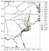
14 GFS runs in a row through the 12Z have turned back W into the coast. But the 12Z is slightly further N and the 6Z and even moreso the 12Z GEFS mean is further N than the operational. Also, fwiw being that it’s an inferior model, the 12Z JMA 72 adjusted back N with it in VA vs yesterday’s 12Z JMA 96 in E C GA.
So, as of now the GFS will likely end up wrong, which history all along strongly suggested.
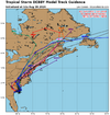
12Z UKMET: landfall Georgetown ~8AM Thu 8/8 and then heads N into VA (~50 miles E of 0Z) followed by NE turn to NE US though not as strong there as 0Z had
12Z Euro: landfall just S of Georgetown ~3AM Thu followed by NNW move into WC NC and then NE move into interior NE US, a little W of UKMET
So, as of now the GFS will likely end up wrong, which history all along strongly suggested.
12Z UKMET: landfall Georgetown ~8AM Thu 8/8 and then heads N into VA (~50 miles E of 0Z) followed by NE turn to NE US though not as strong there as 0Z had
12Z Euro: landfall just S of Georgetown ~3AM Thu followed by NNW move into WC NC and then NE move into interior NE US, a little W of UKMET
Last edited:
Flooding not as bad in Charleston as predicted per fox weather. Drainage systems are working better than expected.

DRAINING: Here's what's going on underneath Charleston's streets - Charleston Business
Listen to this article
 charlestonbusiness.com
ENCSnowdawg
Member
If she intensifies over the Atlantic and make landfall between Myrtle and Georgetown @60mph. Wind gusts of 40-50mph is possible for central and Eastern NC as she moves north.
Last edited by a moderator:
Ron Burgundy
Member
Really looks to be tightening back up right over Savannah

ENCSnowdawg
Member
Further east .png")
I’m always impressed with how efficient the airmass with a tropical system is at adding up rain totals. I have had anything more than a light to moderate rain that started just before 10am. It’s been steady though and already .74” in the gauge.
Whole lotta nothing in Savannah. Yea some places flooded. They always do. Same for Tybee, their police page already reporting little to no damage. The scariest part of the storm to me is the drivers. Driving way too fast on wet roads. Currently. 