Downeastnc
Member
I'm gonna say that the NAM might be too warm.
Betting against NAM temp profiles down the stretch lead to pain and suffering via disappointment.....
I'm gonna say that the NAM might be too warm.
If the h5 look hadn't been trending in a positive direction I would agree with you but something seems fishy to me, idk.Betting against NAM temp profiles down the stretch lead to pain and suffering via disappointment.....
Urban heat island might be saving Charlotte here, making it ever so slightly warmer
Betting against NAM temp profiles down the stretch lead to pain and suffering via disappointment.....
This x 1000. Why Canadian Hi Res is so much more icier v/s Nam, american suite. Very minuscule difference, but it makes huge difference to sensible wx deteails.The track of the coastal low is killing this thing for most.
Honestly, I felt like this would happen but the UHI here is weird compared to other cities because of how spread out Charlotte is and how different areas the city are. South End might stay above freezing while University or Mountain Island lake gets a glaze.Urban heat island might be saving Charlotte here, making it ever so slightly warmer
The last few ice events I witnessed there had glaze near Kannapolis-Huntersville with plain rain once you got into Concord and the University. Probably what’s likely to happenHonestly, I felt like this would happen but the UHI here is weird compared to other cities because of how spread out Charlotte is and how different areas the city are. South End might stay above freezing while University or Mountain Island lake gets a glaze.
Ground temps not a problem, solid as a rock. 20 degrees this morning.
I would definitely stick closer to the NAM than the RGEM.

Yeah temp busted here a few degrees lower this morning near black bear/lake. I'm hoping we get enough low level cold air to keep this sleet for a while then top it with a glaze that would be pretty. I still hate ice though...Ground temps not a problem, solid as a rock. 20 degrees this morning.
Yeah I’m not a huge fan of ice as I like my lights being on.Yeah temp busted here a few degrees lower this morning near black bear/lake. I'm hoping we get enough low level cold air to keep this sleet for a while then top it with a glaze that would be pretty. I still hate ice though...
I just put in a woodstove took the gas stove out to expensive I can cut all I want for a few bucks in gas. My power bill dropped to 150 too with kids and the wife that's killer savings. We loose power too almost every storm they shud put all power underground up this way lolYeah I’m not a huge fan of ice as I like my lights being on.
I hear ya! Should be some nice pics by morning out by the lake.I just put in a woodstove took the gas stove out to expensive I can cut all I want for a few bucks in gas. My power bill dropped to 150 too with kids and the wife that's killer savings. We loose power too almost every storm they shud put all power underground up this way lol
Very interesting because the HRRR is usually too warm at the surface. Hmm.The HRRR actually has snow for extreme Northern MS and Tennessee lol.
Well then
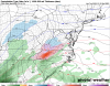
..Eastern North Carolina...
Due to lingering spread among the output of the various models, the
extent of severe weather potential for Wednesday remains at least
somewhat unclear. It still appears that the track of the deepening
surface cyclone may allow for at least a weakly destabilizing warm
sector boundary layer to overspread the Outer and Inner Banks
vicinity by Wednesday afternoon. If this occurs, deep-layer wind
fields and shear probably will become sufficiently strong to support
a risk for organized severe convection.
The 15/00Z NAM forecast soundings for the Morehead City and Cape
Hatteras vicinities (around the 16/21-23Z time frame) exhibit wind
profiles characterized by strong deep-layer shear and very large
clockwise curved low-level hodographs, which appear favorable for
supercells capable of producing a strong tornado. Output from other
models doesn't appear quite as favorable, but this will be monitored
in later outlooks for this time period.
The track of the coastal low is killing this thing for most.

Yeah I'm going to try and take a few I got to drive a Penske moving truck to statesville in the morning my mother in law built a house down there fingers crossed we make it. I'm a little concerned about the sleet with ice on top. I've drove plenty of times on sleet hell it's almost like gravel if u get a few inches but ice on top that's a no go lolI hear ya! Should be some nice pics by morning out by the lake.
Well like clockwork, the 12Z 12k NAM is coming in much colder.

You’re probably right. And with a HP of that strength in that location, it may not be done. The H5 setup definitely forshadowed this coming to fruition at the surface eventually.
And that’s how you get a strong December tornado right before Christmas. ? ?Weather is amazing. Here's the HRRR at hour 31. It has Myrtle Beach sitting at 48 while up the road in Wilmington it's 70.
View attachment 57831