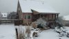
February 2015 had a few winter events that I can recall, most light but two big ones, the Northeast Georgia ice storm, and the significant snow event in North Georgia. There may have been more that I was forgetting that happened in TN. I think the last one was an ULL that completely screwed over Atlanta proper with a dry slot after they were too warm at the beginning. I can't lie, I was laughing at the radar that had Atlanta completely blanked out on that system during that night...and iirc, after the early rain, it was cold enough for it to snow there too but the dry slot kept them from anything at all.
That's the story with ULLs though, you can win big but then lose big. A lot of areas in Atlanta proper won big on 3/01/09 and they lost big on 2/25/15.
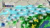
Edit: Here it is, in all it's glory, but truthfully, being dryslotted is for the birds. Atlanta was at 35, but it was very much workable if they didn't get that awful dryslot. Instead of getting snow and possibly heading down to freezing, it was miserable, mid 30s light drizzle because of that dry slot.

 and even now a struggle to get much above freezing(the forecast is still around 50, glwt)