GeorgiaGirl
Member
Not going to be a pretty GFS run because of this ugly cutoff low...
It phases and doesn't go way north. Actually didn't see any extreme warmth this run so far at 312.Not going to be a pretty GFS run because of this ugly cutoff low...

Isn't cold in Eurasia bad? That gives us warm in the East right?
Just using the terms Judah was usingIt isn't nearly that black and white, especially with you generalizing about "Eurasia", which is what, 10K miles long?
And just used to waiting on the unicorn SSW events to happen , and when they do in the last few years, cold dumps into Europe and Asia, we torch, 2013 style!It isn't nearly that black and white, especially with you generalizing about "Eurasia", which is what, 10K miles long?

And just used to waiting on the unicorn SSW events to happen , and when they do in the last few years, cold dumps into Europe and Asia, we torch, 2013 style!


Wow Mexico's historic winter continues if that look is right. Crazy.-EPO goes a long way on the GEFS this run. 6-10 solid cold in the 6-10. See why the mean snowfall is so far south.
View attachment 3711
Too much hit and run lately. I need to see a big high come down from up there in cold land, and hit us squarely on the chin, lol, don't need it just rubbing up against meThe 12z GFS was warm but not ridiculous, I'm fine with it.
")
Fat rats predicting the weather is about as helpful at Goofy out at day 14, lol. My moles do a much better job, when they aren't drunk, trippin', or travelling with the Molettes on some shopping spree.Buckeye Chuck also says 6 more weeks of winter. Its unanimous folks.
T that's a good look, would be nice for Euro and EPS to start looking like this!Hopefully this has legs from the GEFS. Nice trend inside day 8.View attachment 3713
Anyone wanna put the GEFS members on here?

It's just fun to look atHere's 240. Anything further out is most likely fantasy snow. Actually, now that I mention it, most of this probably is too.
View attachment 3714
Or too far south, as I recall, lol.I LOVE cutoff lows this time of year but not that far north.

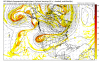
Webb,Im sorry but in no way, shape, or form is this subtropical ridge from the international dateline to western Europe going to verify, a trough is going to show up somewhere in that ridge axis. It tried to blowtorch the entire CONUS a week ago and we see how that's panning out...
View attachment 3715
The GFS Ensembles showed something simlar. Not very sure if the cold is going to make it to the Southeast U.S this month or not.Im sorry but in no way, shape, or form is this subtropical ridge from the international dateline to western Europe going to verify, a trough is going to show up somewhere in that ridge axis. It tried to blowtorch the entire CONUS a week ago and we see how that's panning out...
View attachment 3715


The GFS Ensembles showed something simlar. Not very sure if the cold is going to make it to the Southeast U.S this month or not.View attachment 3718


On the contrary, that ridge extending that far likely isn't going to be what we see, however, on the other board I saw someone say that strong MJO events favor a ridge over most of the US...
Someone that I would say is knowledgeable too, I saw it from a met on the TN Valley subforum.

Im sorry but in no way, shape, or form is this subtropical ridge from the international dateline to western Europe going to verify, a trough is going to show up somewhere in that ridge axis. It tried to blowtorch the entire CONUS a week ago and we see how that's panning out...
View attachment 3715
I don't agree that just having above normal 500 mb heights in a location is enough to say there is a 500 mb ridge being depicted there. For example, I don't think that is a 500 mb ridge in the Ohio Valley and Great Plains despite the above normal heights. That looks more like a trough to me considering the shape of the height lines.
I was going to post this. There is a mean trough across at least the northern US on that EPS plot. The height anomalies are above average but it's not showing one continuous ridge .
I'm pretty sure it was implied that this was an anomalous ridge. There's normally a trough in the means over the OH Valley anyway so I'm not sure you could really glean any useful information out of saying there's still a trough in the means there even if the heights and surface temps are well above normal as the EPS shows
Yeah you did imply that. And we are both saying it's not a ridge .
But what you said was incorrect.

A brief moment to check on the boards and I see a debate on if colors on a map is a ridge or not. From my standpoint, the orange does not equal a ridge. It is an anomaly. It's like saying it's going to be cold in Miami if it's showing below average. It comes down to the intensity and the actual strength. For instance, what defines a ridge at 500MB? It's kind of like what defines a low VS a high and at what MB does it change? The anomalies in between the two centers aren't that above compared to the actual two centers I see.One hell of a discussion to wake up to ...
While it's an anomaly, is it truly a ridge? Does the actual flow of air connect completely and at a decent magnitude,are they barely connected and barely touching, or are they completely disconnected and slightly separated? You also have to remember the resolution on these things this far out is horrendous, so it may appear in a way that isn't true.It's an anomalous ridge was my point.