Storm5
Member
Yuck is a good word

Sent from my SM-J320VPP using Tapatalk

Sent from my SM-J320VPP using Tapatalk
Insanity, I guess GROUND TEMPS and SUN angle were not an Issue>>>>???
Sounds like "Cousin IT" on the Addams Family, yes I am showing my age and awe of this, this is ridiculous..
North Atlanta yes.No, they've had enough. Throw someone else a bone, Mother Nature.
Im pretty sure south and east of Atlanta got some snow with the January storm.North Atlanta yes.
South Atlanta and east of Atlanta towards Athens hasn't seen much at all.
Barely an inch.Im pretty sure south and east of Atlanta got some snow with the January storm.
Lordy. If EPS is correct it might take a week or two to get out of that.Yuck is a good word
Sent from my SM-J320VPP using Tapatalk
Lordy. If EPS is correct it might take a week or two to get out of that.

Why would the EPS be correct at 2mT at Day 15 when it cant even get Day 9-10 right at 500mb?
Sent from my iPhone using Tapatalk
Well I did see sleet in the Orlando/UCF area on January 9, 2010. It didn't accumulate where I was at but it did come down pretty hard briefly.For the record, I am not in Central Florida (thank the good Lord) ...
Comparing the latest run. Appears a little closer to 8.I'm not saying it is correct, but if it were to be, this would be why.

Comparing the latest run. Appears a little closer to 8.

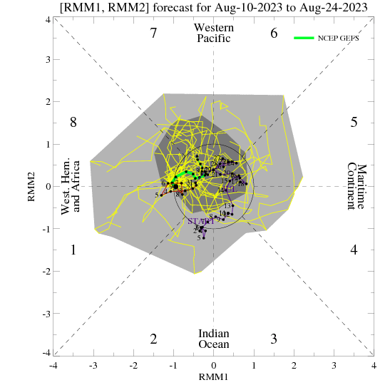
The only thing of recent days that concerns me is the potential trend towards the MJO not progressing into Phase 8, which would likely result in about what the long range ensembles are showing. This whole pattern change idea for me has been largely driven by that potential. I know there are some other factors also potentially in play with the PV split that could help out, but if the MJO doesn't cooperate it's going to make things more complicated. And as Webb has explained, that idea could have legs based on SSTs with Nina. We will see.
I'm not saying it is correct, but if it were to be, this would be why.
It's going to reach phase 8 either with amplitude or into the COD, either case favors cold in the eastern US and RMM may not flesh this out because it uses OLR that has an eastern hemisphere bias. The upper level circulation of the MJO will remain in tact even as we lose the convection and will impart forcing onto the North America wave pattern that resembles a phase 8 event. Even if this index says the MJO just magically dissipated when it reached phase 8 that's going to be far from reality when you have a 3.5-4 sigma event in phase 7, some significant remnant of the MJO will remain when it hits the Western Hemisphere (phase 8-1)Exactly how I feel at the moment. If the mjo was projected into phase 8 I feel the ensemble models would look colder long range.
What an unfortunate tease that would be...high amplitude B-line toward favorable MJO phases, then right before it gets to cold and snowy phase 8, it hits the breaks and makes a hard U turn. Of course. Hopefully it's still correcting and we get nicely into phase 8. My worry though it's ALL the major ensembles showing the warm ridging and the phase 7 turn. It's not just the EPS that has been having accuracy problems.
I havent seen a lot of people mention it but it looks like its going to snow in TN tonight. Maybe an inch for Knoxville and a dusting to quarter inch for Chattanooga.


That's what she saidNo shortage of rain over the next 8 days . Good thing cause im 3 inches behind
Sent from my SM-J320VPP using Tapatalk
Wl, you are right and trying to stay optimistic. Not sure it working or helping any of us right now. We're just in a down mood right nowNo shortage of rain over the next 8 days . Good thing cause im 3 inches behind
Sent from my SM-J320VPP using Tapatalk


Damn, im getting tired of waiting. Hurry up! And that still doesnt look cold enoughHere comes the arctic lol
Sent from my SM-J320VPP using Tapatalk
I'm sure the GFS will change drastically again once it sees phase 8 or a move to the COD in 8.Overall trends continue warmer for the SE US on the model consensus through the 12Z GFS.
Edit: ATL gets barely below 0C at 850 next 2 days and then never goes below 0C rest of the 12Z GFS. 6-10 and 11-15 periods warmer than normal at 2 meters SE US.


I don't know about a decent amplitude, but I think it'll get there.This could honestly move into 8 on modeling in a decent amplitude in the next few days then a lot of folks will stop panicking. I’m not sold on the nosedive in phase 7 yet
My guess is that will either correct colder as we close in or be transient in nature. Will we ever get into a snowy pattern? I don't know....The 12Z Gfs don't look good for cold in the long range.View attachment 3673
What does it means for the Southeast if it goes to 8? What is colder 7 or 8
I don't know about a decent amplitude, but I think it'll get there.

What does it means for the Southeast if it goes to 8? What is colder 7 or 8
I don't believe that will end up being the case. Everything looks good through 240 (and I use "good" loosely) and then shortly after, things get nutty. If in 10 days, we're seeing that solution showing up imminently, then I'll toss the rest of the month. I don't think that will be the case.Whether the MJO gets to phase 8 all global ensembles agree on dumping deep cold into Europe and Asia. Hopefully it can get back to North America before March.
View attachment 3675