Yeh, we will waste 90% of the storm, but I think some back in flurries is certainly likely. And I’ll take it, after dealing with a 36° rain all day Thursday.Pulled from the recent 3KM NAM, the area circles during the heart of the precipitation makes me a sad panda. It gets beaten down over time, but not until the best moisture is leaving the area:
View attachment 35345
-
Hello, please take a minute to check out our awesome content, contributed by the wonderful members of our community. We hope you'll add your own thoughts and opinions by making a free account!
You are using an out of date browser. It may not display this or other websites correctly.
You should upgrade or use an alternative browser.
You should upgrade or use an alternative browser.
Wintry February 19-21, 2020 Winter Storm
- Thread starter Six Mile Wx
- Start date
NCCWOP9077
Member
Same here I am cautiously optimistic here in Wilson county.Models are starting to consolidate along the 264 corridor with some good totals. If by this time tomorrow they are still showing 6+ then it is gonna be something we haven't seen in several years.
Sent from my SM-J727U using Tapatalk
Webber what do you think I should do stay here at UNC Charlotte or head back and try my luck back in Raleigh (apex to be exact) ... feel like deformation banding could hit Raleigh the best
Webberweather53
Meteorologist
I would absolutely head to Raleigh, no hesitation lol. Even if there’s mixing, the potential of legit, seriously heavy snow is much higher in the TriangleWebber what do you think I should do stay here at UNC Charlotte or head back and try my luck back in Raleigh (apex to be exact) ... feel like deformation banding could hit Raleigh the best
snowlover91
Member
Even with all the potential mixing, once you flip to all snow, the bands are going to be nuts in the coastal plain as the coastal low cranks up on the back end of the storm
At this point in the winter I’ve reached the point of desperation that I’d be happy with flurries lol. But I am getting a bit excited, if this verifies like the nam shows it’ll be my first big snow storm that I’ve tracked for my area. 3km is showing some signs of intense banding in the 18z run as that coastal cranks, those bands should really put out some impressive rates.
This is more realistic for N AL than the 12km NAM due to likely temperatures, IMO.
Final total from NAM 3km.
Cadi40
Member
Here in East Charlotte I’m just skeptical of the dreaded warm nose, however I’m hoping it’s being overdone on the models but that’s almost never the case. I’d love to see upwards of 6 inches but with a warm nose I just don’t know how doable that is.
WxBlue
Meteorologist
Not yet, I’m riding that fine line of being all snow or mixing with a lot of sleet. I know these mixing zones oftentimes are further north than even the NAM shows but I’m hoping I can stay all snow... and that it’s right with the qpf. I’ve only seen a foot of snow once in my lifetime and that was the December 2010 Christmas storm, would love a repeat here.
I actually live in Zebulon/Middlesex area so I'm right there with you, dude. Super excited about this one.

Cadi40
Member

Brad P’s first call forecast, very conservative as always with him. Hoping the deformation band will set up along the 85 corridor which is typically where it occurs in recent memory. Webber, any thoughts on where the deformation band may be located?
Van posted his first call map and is going off of the ensembles (SREF. EPS and GEFS)
"Potential Snow Update
First Call on Amounts
Posted 5pm Tue. Feb 18, 2020
Feel free to SHARE
Since last week we have been talking about the possibility of snow near Feb. 20th. As we get closer, we have more and better information to work with. Still, just 48 hours away, the models are not in very good agreement. We have guidance suggesting anything from No Snow in the Piedmont to more than 7 inches. We can't dismiss any of this information at this point. So to come up with a forecast (First Call in this case....I will make 3 including the Final Forecast as we get closer) I look at all models, but put most of my confidence in the Ensemble. The ensemble is multiple runs of the model and this usually gets closer to the actual outcome. The trend I see here is more in eastern NC where moisture should be greater and confidence is higher that it will actual reach those areas. Here in the piedmont, there are solutions that keep the moisture to our south while about 60% show it reaching us. Still, many that show it reaching us, have it very light. Given all of that, I currently have the piedmont seeing near or just under 1". I also have parts of eastern NC seeing more than 3 inches. Stay tuned as new model data arrives, we will hopefully see the models agree more and that will allow us to become more certain in our forecast."
packfan98
Moderator
18z GEFS Beefed up as expected. Time to put less value in the ensembles and go to the operationals and short range modeling.


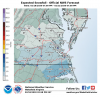
Link?This is probably the closest to the true RPM (out to 72 hours) that I have access to, but as you see, it's quite a bit different, in the Deeper South, especially(midlands of sc), and seems to try and match what the RPM modeling posted in various threads and our local forecasts are starting to show:
View attachment 35349
Webberweather53
Meteorologist
View attachment 35351
Brad P’s first call forecast, very conservative as always with him. Hoping the deformation band will set up along the 85 corridor which is typically where it occurs in recent memory. Webber, any thoughts on where the deformation band may be located?
I generally agree with @snowlover91 that it will be near the US 264 corridor, the Triangle area and points E-NE have the potential to get crushed on the back side of this storm by frontogenetically forced bands in the CCB imho. If we play our cards right in the next 24 hours, this has the potential to be the best setup since Dec 2010 for folks in the north-central coastal plain and far eastern piedmont.
packfan98
Moderator
This seems to be much better than the 12z, correct?
Nerman
Member

The only chance I'm seeing for the Atlanta area is if that wedge being formed with the CAD is being underdone. It's also retreating really fast so that would need to change too. This just isn't trending in our direction and probably not our storm. We just got a good one though so I'm happy for everyone else that hasn't had anything this winter. I hope our neighbors in the Carolinas get pasted!
Cadi40
Member
What are your thoughts on areas east of Charlotte?I generally agree with @snowlover91 that it will be near the US 264 corridor, the Triangle area and points E-NE have the potential to get crushed on the back side of this storm by frontogenetically forced bands in the CCB imho. If we play our cards right in the next 24 hours, this has the potential to be the best setup since Dec 2010 for folks in the north-central coastal plain and far eastern piedmont.
BHS1975
Member
Here’s the thing about frontogenic bands, they normally arrive earlier than forecasted, they normally have intense rates, when it moves in, snow immediately becomes heavy, not light snow for some time to heavy, it becomes heavy quick, and also areas outside the intense frontogenesis can get a nice ol minumum
Feb 2014 did just that.
Sent from my iPhone using Tapatalk
Webberweather53
Meteorologist
If we continue along the path we’re currently on and knowing biases w/ overrunning and WAA, I personally thinking something in the general ballpark of 2-5” is probably what we’re looking at, the low end may be achievable with sleet only in the Charlotte areaHere in East Charlotte I’m just skeptical of the dreaded warm nose, however I’m hoping it’s being overdone on the models but that’s almost never the case. I’d love to see upwards of 6 inches but with a warm nose I just don’t know how doable that is.
This seems to be much better than the 12z, correct?
yes, matches up with icon IMO
The NAM and the GFS is showing some backside snow showers for parts of the metro area Thursday night into Friday morning.View attachment 35357
The only chance I'm seeing for the Atlanta area is if that wedge being formed with the CAD is being underdone. It's also retreating really fast so that would need to change too. This just isn't trending in our direction and probably not our storm. We just got a good one though so I'm happy for everyone else that hasn't had anything this winter. I hope our neighbors in the Carolinas get pasted!
blueheronNC
Member
Mike Maze WRAL effectively wrote this off as a non-event to open the 6pm news. He’s riding the EURO. Suppressed solution and insufficient cold air source.
Latest from FFC:

Link?

WRF Real-Time Forecasting
Real-time mesoscale model weather forecasts are produced by the Weather Modeling and Research Section at NCAR MMM primarily using the WRF model
MichaelJ
Member
Still don't expect a lot of accumulation from Salisbury North and West all the way into the Triad and foothills. A good 6-8 inches is possible (depending on temp profiles) from Raleigh East. Somebody will get the lollipop and could end up with 10-12" depending on just where the deform band appears. If I had to pinpoint a specific location for that I would say generally the Kinston to Greenville area
Last edited:
NCCWOP9077
Member
Yep he admitted he puts alot of stock in the Euro ensemblesMike Maze WRAL effectively wrote this off as a non-event to open the 6pm news. He’s riding the EURO. Suppressed solution and insufficient cold air source.
Sent from my SM-J727U using Tapatalk
WRAL really seems to be siding with the EURO on this one. Ever since the January 2017 bust they have been extremely conservative with totals.
This was Greg Fishel from earlier.Mike Maze WRAL effectively wrote this off as a non-event to open the 6pm news. He’s riding the EURO. Suppressed solution and insufficient cold air source.
I CONTINUE TO BE UNDERWHELMED BY THIS UPCOMING SYSTEM
Just a quick update, as there is no way I should be up this late. In my estimation, the upper level pattern is wrong, the surface high is in the wrong place, and most if not all of the precipitation will fall while temperatures are above freezing. For snow lovers, I do not believe this upcoming late week weather event is going to be your meteorological messiah. Might we see a few flakes? Yes, but every time I venture outside you've got that so what's the big deal??? More to come later today.
B
Brick Tamland
Guest
Mike Maze WRAL effectively wrote this off as a non-event to open the 6pm news. He’s riding the EURO. Suppressed solution and insufficient cold air source.
This is what they are showing. They have to be hugging the Euro, and just totally discounting the NAM and all the other global models falling in step with the NAM and showing a big storm for NC, even with the NAM doing better than the Euro as Webber explained here.

B
Brick Tamland
Guest
WRAL really seems to be siding with the EURO on this one. Ever since the January 2017 bust they have been extremely conservative with totals.
Actually, ever since the December 2000 bust.
Jon
Member
Honestly and I'm being gracious here, I don't know of a single forecasted snow storm he didn't bust low on. He's partial to the model with the least amount of snowfall. Loved him as a person and how he shared his nerdy wx knowledge on TV, but don't trust him with snow storms. No one remembers when you bust low, they ALWAYS remember when you forecast too much snow and it didn't happen. I always keep this in mind when looking at snowfall predictions from TV mets.This was Greg Fishel from earlier
I CONTINUE TO BE UNDERWHELMED BY THIS UPCOMING SYSTEM
Just a quick update, as there is no way I should be up this late. In my estimation, the upper level pattern is wrong, the surface high is in the wrong place, and most if not all of the precipitation will fall while temperatures are above freezing. For snow lovers, I do not believe this upcoming late week weather event is going to be your meteorological messiah. Might we see a few flakes? Yes, but every time I venture outside you've got that so what's the big deal??? More to come later today.
I think if we get some consistent NAM runs for tonight and tomorrow morning than we’re looking at those local METS to start changing their tune a bit and at least bringing up the potential for a bigger deal.. especially with how close we’re approaching ... I mean winter storm watches would have to go out what.. tomorrow??
I agree! Here in the Foothills looks to be where the very minimum precip will be. I think I would be lucky to get an inch here, but really expecting less than that at this timeStill don't expect a lot of accumulation from Salisbury North and West all the way into the Triad and foothills. A good 6-8 inches is possible (depending on temp profiles) from Raleigh East. Somebody will get the lollipop and could end up with 10-12" depending on just where the deform band appears. If I had to pinpoint a specific location for that I would say generally the Kinston to Greenville area
Honestly and I'm being gracious here, I don't know of a single forecasted snow storm he didn't bust low on. He's partial to the model with the least amount of snowfall. Loved him as a person and how he shared his nerdy wx knowledge on TV, but don't trust him with snow storms. No one remembers when you bust low, they ALWAYS remember when you forecast too much snow and it didn't happen. I always keep this in mind when looking at snowfall predictions from TV mets.
But can you blame him? Brad P. is the same. He is by far my favorite meteorologist, ever. But ever since, I think it was the January 2018, where he predicted like 6 inches and we ended up with slop. People were literally cussing him out, making threats, just insane behavior. People are picky when it comes to snow in the South. It's not that often we get a system to track and this one has proven to be quite difficult.
Snownut
Member
Chris Justice has already put in a FB that he was very conservative right now with his totals. He knows they are gonna go up tomorrowI think if we get some consistent NAM runs for tonight and tomorrow morning than we’re looking at those local METS to start changing their tune a bit and at least bringing up the potential for a bigger deal.. especially with how close we’re approaching ... I mean winter storm watches would have to go out what.. tomorrow??
Sctvman
Member
RPM on local Channel 5 showing possible wintry weather all the way to CHS early Friday AM (3-6am).
SimeonNC
Member
I actually think that is kind of bullish for him.View attachment 35351
Brad P’s first call forecast, very conservative as always with him. Hoping the deformation band will set up along the 85 corridor which is typically where it occurs in recent memory. Webber, any thoughts on where the deformation band may be located?
Dawgdaze22
Member

Don’t know if this has been posted but this is the breakdown when models are split on winter storms in the SE
Sent from my iPhone using Tapatalk
Dawgdaze22
Member

Don’t know if this has been posted but this is the breakdown when models are split on winter storms in the SE
This only goes back to December 2016 FWIW
Sent from my iPhone using Tapatalk
Sent from my iPhone using Tapatalk