D
Deleted member 1449
Guest
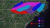
That was probably the best run of the NAM yet for the Triad (~8" at GSO), although I noticed it was a bit slower than previous runs. All hail the NAM--for now.

yea, very encouraged to see the 3km back off a bit on the strength of the warm nose. hope to see that trend continue over the next 24hrs.The temperature profiles on the 3k NAM vs 12K is ever so slight that makes this really interesting. The 12K has a warm nose of a degree or so that causes it to start as sleet for 2-4 hours and the 3K has the warm nose basically not there. The 12K still has a good swath of 2-5 inches with the sleet. The 3K around 1-4 inches. The good thing is the 3K is better at temp profiles so we could be looking at a bigger dog in the upstate up I85 to Charlotte.


3k NAM a little less, but that's only relative. I would 100% take this in a heartbreak.
View attachment 35299


I know it’s not the same setup, but I can’t help but think about the 1/3/2018 storm that the Euro completely blew it. 24 hours before that storm it was showing nothing outside of the immediate coastal areas of the Carolinas while the NAM was bringing accumulations back Central NC. The NAM was right on that oneStating the obvious here, we're approaching the general forecast lead time where you can't immediately ignore the NAM or any other CAMs for that matter even if they differ considerably from the globals.
My goodness this is so close to greatness for north Georgia.Great run for the Huntsville area
Sent from my iPhone using Tapatalk
Just like not 1 had last system .. EURO IS TRASH IN THESE SET UPS ... maybe not trash but ...This is not a reflection of what scenario I’m pulling for or what I think will happen but here’s something to keep in mind; not one EPS member looks anything like the NAM.
I couldnt remember the model outputs on that one. Its nice to see that its trustworthiness has legs. Its proven itself even when its back is against the wall.I know it’s not the same setup, but I can’t help but think about the 1/3/2018 storm that the Euro completely blew it. 24 hours before that storm it was showing nothing outside of the immediate coastal areas of the Carolinas while the NAM was bringing accumulations back Central NC. The NAM was right on that one


I know it’s not the same setup, but I can’t help but think about the 1/3/2018 storm that the Euro completely blew it. 24 hours before that storm it was showing nothing outside of the immediate coastal areas of the Carolinas while the NAM was bringing accumulations back Central NC. The NAM was right on that one

Just like not 1 had last system .. EURO IS TRASH IN THESE SET UPS ... maybe not trash but ...
It may not be trash but it sure is in the recycling bin. Been terrible here the past 12 months.Euro is not trash in any form or fashion, regardless of the setup. The NAM is on it's pooping own dude.
The NAM sure beat it out on last two storms. Overrunning storms the NAM is much betterEuro is not trash in any form or fashion, regardless of the setup. The NAM is on it's pooping own dude.
I just remember that storm everyone was saying in Central NC how much they wished the Euro was on board. Even when we see the transfer to the coastal, coastal storms always seem to have a more expansive precipitation shield on the west side. That’s why I wouldn’t dismiss the Hwy 74 corridor from Union County east to get in on the deform band for at least a timeI couldnt remember the model outputs on that one. Its nice to see that its trustworthiness has legs. Its proven itself even when its back is against the wall.
Euro is not trash in any form or fashion, regardless of the setup. The NAM is on it's pooping own dude.
I was gonna say near Mobile/Pensacola.Yes. Weak low near New Orleans. Woof.
And I’m sure that is in the US as a whole (maybe even world wide?). But it comes down to what have you done for me lately?Still has the best skill score, globally, for many years by a good deal over GFS and CMC.
Where are you exactly? Wilson?Literally has me on pinger/snow line and any more warm nose puts me in the sleet at least for part of the qpf.
The Euro is king beyond day 3. One we get into the short-range, mesoscale modeling typically trumps the Euro.
Edit: What Webb said
Still has the best skill score, globally, for many years by a good deal over GFS and CMC.
I’m simply talking to Webb’s point on its recent performance with winter storms and winter weather set ups .. the NAM is not alone almost all other CAMS show the similar set up the NAM is showing ... I believe the euro is a bit on its own right now .. as it usually has been “dude”Euro is not trash in any form or fashion, regardless of the setup. The NAM is on it's pooping own dude.
Where are you exactly? Wilson?
They don't call it the European Centre for Medium-range Weather Forecasts (ECMWF) for nothing.
It's the fact it's being called trash. That's misinformation, 100%.
There is no way on earth I see this happening. I mean the ECMWF says noooo....Its also still snowing.....
I got a nice 6” out of that one. I’m hoping for that again, but I’d take 2-3”.The EPS completely blew the overrunning precipitation that entered the southern piedmont and southwestern coastal plain of NC, even the day before that event.
View attachment 35308
View attachment 35309
To me the Euro is like all models and is a tool, not a forecast. It has its known biases that forecasters have to know to be able to use it effectively. The one question I always have in these situations when models are not agreement is if it was the Euro showing the big storm right now and the NAM not, would forecasters still lean on the Euro when making out there forecasts?Is it trash in general? No, but in a particular subset of cases, yes it definitely can be.