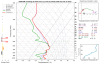
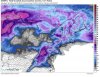
• Hello, please take a minute to check out our awesome content, contributed by the wonderful members of our community. We hope you'll add your own thoughts and opinions by making a free account!

Wintry Feb 19-20 Possible Front-End Snow/Ice Thump

Nam is a good .5-.75 of precip as frozen/ freezing. Quick look at the soundings and they seem to say pretty big sleet event

Sent from my SM-G955U using Tapatalk
 
I can’t see the past CONUS 500mb maps but I’m assuming the NAM is showing stronger confluence allowing the HP to become more Classical and fetches in CAA at the sfc through a portion of the event
D5837137-AAC6-4B5B-8366-BCA4654E006A.jpeg
 
One must think ... did the Fv3 catch something here... I think maybe if a storm can get through the 160 dark hour period where the Fv3 usually loses its fantasy storms ... than maybe those storms are legit
 
Not to be a Donny downer but lemme tell y’all a lil sumn bout that 60hr NAM...
 
To show how much potential this event had, if we get the solution the NAM is showing with this look at H5, that’s crazy, imagine what would happen without the SER so strong, if I was outside CAD zones, I’d be fuming 0C0CB9BE-4639-4DEC-BA48-7B735B9A2ECF.png
 
Last edited:
To show how much potential this event had, if we get the solution the NAM is showing with this look at H5, that’s crazy, imagine what would happen without the SER, if I was outside of CAD zones, I’d be fuming View attachment 15888
Right. Why can’t we trade a SER for a Greenland ridge?
 
Next two days are highs in the 50s with nights not cold enough to help the surface. Plus it starts as rain. Add on no evening cooling due to cloud/timing. Goodluck with that (Mooresville to Raleigh crowd). My worries would be there and southward that this busts to cold rain. However, I have some growing concerns for the foothills and mountains. But..even there I am still believing this pattern supports mostly mixed events and snow will be quiet limited in amounts for the rest of winter (less than 6”) when looking at the widespread impact at or below 3,500ft. I still believe the pattern will try to make a switch to snowier versus these freezing rain events in March. If you have questions please ask but bare with me getting back to you thank you and god bless hello cold rain
 
Rgem has dynamical cooling and a burst of heavy snow in the mountains with 850s crashing, based of looks that 850 crash was headed east
 
FWIW the Canadian destroys 421 Boone to Winston. Prob going to see a Winter Storm Watched issued Monday near this area. However, this is near 3 NWS offices zones and I expect a lot of arguing with a few certain individuals. I am currently looking at the Mount Rogers, Virginia area for a place to chase. I always look for the northern extent maxima when chasing as the model guidance is often poor on the southern edges (Wilkesboro in this case).
 
Back
Top