Could make a run towards 80*F today, with sunshine.
Some of the trees are already starting to bud and bloom.
There will be one or 2 nights in March or April in the teens/low 20s
Could make a run towards 80*F today, with sunshine.
Some of the trees are already starting to bud and bloom.
Oh I forgot it sucks lmao
Record high to beat in Charlotte today is 74, KCLT is already at 73F and it's 11am.
Is it late May, gonna for sure be in the lower 80s
Hit 89 in early March here about 2-3 years ago, definitely gets you in the mood for spring then the cold comes to bring you back to reality.

The warmest day this early in the calendar year at Charlotte was Feb 3, 1989 where we hit 81F, I think we could seriously challenge that today.
It managed to snow 2 times later in February 1989, with that storm on the 17th-19th being preceded by temps near 80F within 36 hours of the event beginning. So much for warm ground temps.
View attachment 15250
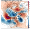
View attachment 15249
seems obvious snow in Seattle almost always = no snow in Atlanta as usually trough in west usually = ridge in east. I'd be curious if we compare times when it widespread snowed in the southeast, what exactly was the weather in Seattle, as in what was the temp, what was the weather there. seems pretty cut and dry, but wonder if the data was compared, would something stick out in terms of Seattle weather when we got a hit in the SE. like if you found that while it was always warm in Seattle during a hit here, did 80% of the time it was rainy and warm, or clear and warm, etc. Some numbers only Larry could pull probably.
It will be interesting to see if this record warmth is balanced out by some solid cold to end the month. It would seem that’s what happened February of 1989?
Well. we know it is being balanced now by major cold in the NW half of the US. Also, the first half of Feb of 2019 is looking to be much warmer than Feb of 1989. Whereas the first half of Feb of 1989 averaged warm, it actually had a few well below normal days with the lowest at 21. This time nothing like that is being forecasted with the lowest only down to near 32.
Since records started 1879-80, I was unable to find no Feb that turned around from a very warm 2/1-14 to a solidly cold 2/15-28. But perhaps we'll get some solid cold late month for a few days.
yes I'm sort of ashamed i even asked that question. I guess where i'm going with this, is, it seems when we are say a day or two out from a storm chance, if we had some kind of other marker to look at instead of just going to the short range models, and then watching the sky, since most of the time something goes wrong. Maybe its not Seattle, but maybe there is some other city that showed "x" almost everytime the storm worked out for us say between ATL and Charlotte. I chose Seattle cause its about as opposite as you can get from the SE. something like this would take big data and is sort of mby'ish. Just trying to think outside the box. thanks for the reply though!I don't need to do it as your assumption is correct. -PNA = NW US cold/SE US warm. Major snow in Seattle is almost never a good sign for the SE.
Interesting, thanks for sharing that data and research, I always enjoy reading your posts! I haven't seen the D11-15 EPS posted recently, I'm assuming they've taken a step back from the colder pattern to a warmer one?
The warmest day this early in the calendar year at Charlotte was Feb 3, 1989 where we hit 81F, I think we could seriously challenge that today.
It managed to snow 2 times later in February 1989, with that storm on the 17th-19th being preceded by temps near 80F within 36 hours of the event beginning. So much for warm ground temps.
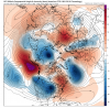
View attachment 15250
View attachment 15249
This morning's 0Z EPS was awful overall. Only near and at the very end of it was so-so/similar to the prior run. But I don't care much about the mirage at hour 360 when hours 168-312 are much warmer overall.

For the SE to ever get to a cold dominated pattern and lose the SER, that strong/stable N Pac block has to go bye bye. It is killing our winter now.
.png")
From Radiant this morning:
"The large scale pattern for most of the next two weeks can be characterized by the –PNA. PNA stands for Pacific/North American pattern, with its phases being associated with strong fluctuations in the strength and location of the East Asian jet stream (NOAA). When in its negative phase, that jet stream becomes retracted toward east Asia, blocking activity increases over the northern Pacific, and a split flow configuration evolves in the central Pacific. For the US, a strong subtropical jet stream results in unsettled conditions for the Eastern Half, a cold response in the Northwest and warm response in the Southeast. The PNA is projected to hold in its negative phase through the 15 Day period, and thus the temperature forecast has an element of persistence among periods. Later in the 11-15 Day period, models are showing a tendency to change the northern Atlantic state to one characterized by a –NAO. This could change the US response, with lower confidence as it relates to the durability of warm ridging over the South and East. We keep confidence low regarding the output of models, as they are often biased to over-phase features in these setups. Phasing of troughs may have a role in evolving the –NAO projected in models."
Man, I hate -PNAs!
11-15 day period in weather is symbolic and the equivalent of 70 times 70 in the Bible (for those who may not know basically infinite)That is like the longest 11-15 day period in history. I would swear that it has felt like 90 days or something.
Larry if I cut my finger off right now and then someone says, it could be worse so and so cut his arm off...... while true it doesn't make my pain go away. But I appreciated the effortWhen looking at ALL ATL winters back to 1878-9 to make folks feel better, it isn't even close to winters like 2016-7. Only one of the 12 warmest, 2015-6 (10th warmest) , was El Nino:
Warmest ATL DJF
1. 1889-90: 54.3
2. 1879-80: 52.4
3. 2016-7: 52.3
4. 1931-2: 51.9
5. 1956-7: 51.6
6. 1949-50: 50.6
7. 1948-9: 50.4
8. 2011-2: 50.3
9. 1881-2: 50.3
10. 2015-6: 49.5 warmest El Nino
11. 1998-9: 49.3
12. 2012-3: 49.2
13. 2018-9 48.9 projected
So, it has been a lot worse!
No data research done on my part but I do think when Seattle gets snow it usually mean we don’t. I can remember a few times over the last 10-12 years that Seattle got some good snows and I was bummed as we weren’t having a good winter during those times. The east and west coast usually aren’t cold or warm at the same time during winter so it seems it would make sense.seems obvious snow in Seattle almost always = no snow in Atlanta as usually trough in west usually = ridge in east. I'd be curious if we compare times when it widespread snowed in the southeast, what exactly was the weather in Seattle, as in what was the temp, what was the weather there. seems pretty cut and dry, but wonder if the data was compared, would something stick out in terms of Seattle weather when we got a hit in the SE. like if you found that while it was always warm in Seattle during a hit here, did 80% of the time it was rainy and warm, or clear and warm, etc. Some numbers only Larry could pull probably.
Well i know one of those March's was not 2012!6 of the 12 warmest ATL winters had a subsequent March that was colder than Feb of 2019 is projected to be. So, something there to hope for.
Well i know one of those March's was not 2012!
Even though your stats show 2016-7 winter was warmer than 2011-2 i will always remember 2011-2 as being the warmest winter ive experienced. Im pretty sure if you were doing astronomical winter 2011-2 would be higher in the rankings.Yep, that was the warmest March on record at ATL. What a miserable DJFM 2011-12 was!
Larry, I'm sick to death of the winterless winters in the deep south. The cherry trees are blooming. My blue berries are budding out. It's high time Katla, or Laki went off and gave us glaciation in the deep southWhen looking at ALL ATL winters back to 1878-9 to make folks feel better, it isn't even close to winters like 2016-7. Only one of the 12 warmest, 2015-6 (10th warmest) , was El Nino:
Warmest ATL DJF
1. 1889-90: 54.3
2. 1879-80: 52.4
3. 2016-7: 52.3
4. 1931-2: 51.9
5. 1956-7: 51.6
6. 1949-50: 50.6
7. 1948-9: 50.4
8. 2011-2: 50.3
9. 1881-2: 50.3
10. 2015-6: 49.5 warmest El Nino
11. 1998-9: 49.3
12. 2012-3: 49.2
13. 2018-9 48.9 projected
So, it has been a lot worse!
9 months of summer, 2 of fallspring, and one of winter, just doesn't get it. When my lowest temp is 24 I throw up my hands. Now, I did love last April, when it was cold and gray all month, so that could ease my angst some were it to occur again, but that's a shabby consolation prize It's 80 today, and that sucks, no way around that.Even though your stats show 2016-7 winter was warmer than 2011-2 i will always remember 2011-2 as being the warmest winter ive experienced. Im pretty sure if you were doing astronomical winter 2011-2 would be higher in the rankings.