-
Hello, please take a minute to check out our awesome content, contributed by the wonderful members of our community. We hope you'll add your own thoughts and opinions by making a free account!
You are using an out of date browser. It may not display this or other websites correctly.
You should upgrade or use an alternative browser.
You should upgrade or use an alternative browser.
Pattern Fab-February 2020 The dark age
- Thread starter Ilovesnow28
- Start date

tennessee storm
Member
Staring feel there will be some snow accumulations west and middle Tennessee later next week. Like storm said little further west digging wth the energy then game on
Storm5
Member
CMC is trying but still need that energy to dig further west

Sent from my iPhone using Tapatalk

Sent from my iPhone using Tapatalk
Hate to say this! But Joey Baker this morning was talking about possible snow again late next week in the Carolina's!
Whos Joey Baker? Another Wilkesboro NWS offfice official. Never heard of him.

This looks very promising, trending in a good direction.

ForsythSnow
Moderator
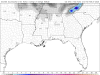
How is it that no other map shows this output? I checked 3 sites and none are like this at this frame.Snow in SE with that second cold shot 3/4! This look is similar to the 18Z GFS!
View attachment 36135
IMO, pattern favors TN/NC border and ski resorts. Multiple snow events or cold air to make snow. BUT, IMHO it does not looks favorable at all East of the mountains.
Snownut
Member
That would definitely support all snow, Board wide!View attachment 36129
Conditions look ripe beginning Thursday for next weekend if we can get any moisture. When will the NAM get in range to tell us whether there will be a snow storm or not?
tennessee storm
Member
Yeah this is starting to look like a apps runner ...IMO, pattern favors TN/NC border and ski resorts. Multiple snow events or cold air to make snow. BUT, IMHO it does not looks favorable at all East of the mountains.
How is it that no other map shows this output? I checked 3 sites and none are like this at this frame.
Are you sure?
BHS1975
Member
Should get a fantasy run here soon with the west trend.
Sent from my iPhone using Tapatalk
Sent from my iPhone using Tapatalk
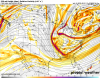
Look out folks, the 12Z GEFS is becoming more bullish for subsequent cold after next week’s cold! Unlike yesterday’s 18Z GEFS, which did NOT support its operational, the 12Z GEFS sort of is supporting its colder operational. Maybe next week’s cold is not the last strong shot:


ForsythSnow
Moderator


Attachments
My map is a 24 hour snowfall ending at hour 288. One of your maps is of snow depth, not snowfall. Also, one of your maps ends at hour 360 (the 15 day snowfall). Finally, different sources employ different formulas to calculate snowfall. (You know that.)
Edit: My map shows only greater than 0.50”

tennessee storm
Member
Faucet has been on all winter. Just hope it don’t get cut off now lolLook out folks, the 12Z GEFS is becoming more bullish for subsequent cold after next week’s cold! Unlike yesterday’s 18Z GEFS, which did NOT support its operational, the 12Z GEFS sort of is supporting its colder operational. Maybe next week’s cold is not the last strong shot:
View attachment 36142View attachment 36143
ForsythSnow
Moderator
Sure one of them ends later, but that's because I wanted to show a bit beyond the timeframe to justify that it's not shown. Snow depth I also know is different, but with 3" on that map it looks like a joke if there is nothing on even the snow depth map. Atop that, soundings do not support snowfall as depicted on that map. The DGZ is too dry, thus it's anafrontal and cold chasing moisture. I don't think those maps have an accurate calculation of snowfall.My map is a 24 hour snowfall ending at hour 288. One of your maps is of snow depth, not snowfall. Also, one of your maps ends at hour 360 (the 15 day snowfall). Finally, different sources employ different formulas to calculate snowfall. (You know that.)
Edit: My map shows only greater than 0.50”
View attachment 36147
Storm5
Member
Some noise for late next week . But that’s all it it at this point

Sent from my iPhone using Tapatalk
Sent from my iPhone using Tapatalk
Jessy89
Member
Some noise for late next week . But that’s all it it at this point
Sent from my iPhone using Tapatalk
It would have to tap gulf moisture in order to be a event outside the mountains
Sent from my iPhone using Tapatalk
Sure one of them ends later, but that's because I wanted to show a bit beyond the timeframe to justify that it's not shown. Snow depth I also know is different, but with 3" on that map it looks like a joke if there is nothing on even the snow depth map. Atop that, soundings do not support snowfall as depicted on that map. The DGZ is too dry, thus it's anafrontal and cold chasing moisture. I don't think those maps have an accurate calculation of snowfall.
I don’t think any clown maps are accurate to be honest. I think you’re right though that my source’s map likely is showing too much snowfall in N GA in this case.
But the idea was to show that it had snow falling, not the exact amount.
ForsythSnow
Moderator
Sure it's at the end of the forecast, but FFC has this in mine
Wednesday Night
A slight chance of rain and snow showers. Mostly cloudy, with a low around 32. Chance of precipitation is 20%.
Thursday
A 10 percent chance of snow showers. Mostly sunny, with a high near 43.
Wednesday Night
A slight chance of rain and snow showers. Mostly cloudy, with a low around 32. Chance of precipitation is 20%.
Thursday
A 10 percent chance of snow showers. Mostly sunny, with a high near 43.
tennessee storm
Member
Think u meant east of the mountainsIt would have to tap gulf moisture in order to be a event outside the mountains
Sent from my iPhone using Tapatalk
Clem282340
Member
If this storm keeps on trending west in time and dig more do you think we have a chance again to see something out of it or is it just only a mountain eventIt would have to tap gulf moisture in order to be a event outside the mountains
Sent from my iPhone using Tapatalk
I agree with birdman here. Looking really good for the spine of the Apps next week. Top to bottom
Storm5
Member
It would have to tap gulf moisture in order to be a event outside the mountains
Sent from my iPhone using Tapatalk
Not necessarily. If it ends up being a clipper type system tenn and NC could do well
Sent from my iPhone using Tapatalk
If we learned ANYTHING from yesterday's storm, we shouldn't be trying to determine exact locations, amounts, storm track until we get into the 3-5 day range. It never works out the way models indicate this far out. All we have right now is pattern recognition. Anyone from the Midsouth to the Carolina's and GA stands a chance of something.
NBAcentel
Member
This past storm proves that we like “suppression“ aswell in the MR, lol
Jessy89
Member
If this storm keeps on trending west in time and dig more do you think we have a chance again to see something out of it or is it just only a mountain event
Sure if it digs enough west of us and picks up gulf moisture. It would put a lot of people at play. But we see just something to watch not a threat yet
Sent from my iPhone using Tapatalk
GeorgiaGirl
Member
Picked up 1.74" of rain in the last batch yesterday. This will be used for testing purposes/for fun, but as a reference, here are what some models have up until the next round ends in my area...
12z GFS: 1.21" and 0z GFS: 1.10"
12z Euro: 1.24"
18z NAM: 1.8"
0z HRRR: 1.07"
Kinda striking how close the GFS/Euro is, even though it's close range, but will look at this after the precip is over and see how much I actually got in comparison.
Revisiting this now, my dad said we picked up 1.15". Not sure what the 0z Euro had before time, but for this test purposes, the last GFS on the night before the rain was the closest!
Storm5
Member
Need the euro further west as well

Sent from my iPhone using Tapatalk

Sent from my iPhone using Tapatalk


Clem282340
Member
Is it trending further west from previous euro runNeed the euro further west as well
Sent from my iPhone using Tapatalk
850's look good for those euro frames over in N Ga /upstate I posted. 925mb is a degree or 2 to warm
pcbjr
Member
Hogtown wedge/CAD ... (see that 44º IMBY at 2:00 PM) ...

Last edited:
Looking ahead I think we are done. I believe back in late January I also did not favor March for anyone outside of the mtns. All chasing will likely be above 3,000ft. Some cold shots sure but looks wet for anyone East of the mtns including here.
- Joined
- Jan 5, 2017
- Messages
- 3,806
- Reaction score
- 6,060
I conquer! We were done back in late December for I-20 folks.Looking ahead I think we are done. I believe back in late January I also did not favor March for anyone outside of the mtns. All chasing will likely be above 3,000ft. Some cold shots sure but looks wet for anyone East of the mtns including here.
Storm5
Member
Cool if we are done we will see y’all next winter
Sent from my iPhone using Tapatalk
Sent from my iPhone using Tapatalk
ATLwxfan
Member
Cool if we are done we will see y’all next winter
Sent from my iPhone using Tapatalk
Yep. Show yourself out. Nobody here can predict the future no matter how hard they bittercast. Would have never thought with the horrible teleconnections and the pac jet that we would get a decent snow in north metro ATL a couple of weeks ago. But we did.
Sent from my iPhone using Tapatalk
This will be a western deal here. Once this air pushes eastward we may have another opportunity in the Carolinas. Still chasing unicorns, nonetheless. 