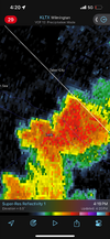
Piedmont trough is persistent. Kind of sucks the whole thing doesn't light upSame location sorthern Nash, around Zebulon area of Wake, another storm... wow
-
Hello, please take a minute to check out our awesome content, contributed by the wonderful members of our community. We hope you'll add your own thoughts and opinions by making a free account!
You are using an out of date browser. It may not display this or other websites correctly.
You should upgrade or use an alternative browser.
You should upgrade or use an alternative browser.
Pattern Dry July 2024
- Thread starter SD
- Start date
Not getting a storm sucks but the consolation prize ofb works
96.3 but I was on the non mixed more clouds side of the piedmont troughRDU hit 100 at 3 PM but this time it doesn’t appear to have been far out of line with nearby areas. It may have peaked at or just above 100. What are other RDU area posters’ highs to this point?

RDU hits 100 for the fifth time this month. Is that a record?
RDU hits 100 for the fifth time this month. Is that a record?
No as they had 9 in July of 2011 believe it or not!
For the 2nd straight afternoon I was just close enough to a storm for my temp to drop but the dewpoint to spike. I went from 97 down to 88 but the dewpoint jumped from 73 to 79, now I’m back up to 94 but the dewpoint is still 78… just disgusting
Shaggy
Member
Same down here. The area SE of Fayettville that 13 inches 2 weeks ago is getting it again. Tons of lightning showing up. Only benefit to me was the anvil blocking the sun.Same location sorthern Nash, around Zebulon area of Wake, another storm... wow
I feel your pain too..Same down here. The area SE of Fayettville that 13 inches 2 weeks ago is getting it again. Tons of lightning showing up. Only benefit to me was the anvil blocking the sun.
Finally over an inch of rain today: 1.15"

Downeastnc
Member
I am over this summer...it's just ridiculous for 7pm

LOL. This one will definitely dislodge any PV directly towards us, not other side of the globe. Why,because its the dead of summer and not winter.
 watchers.news
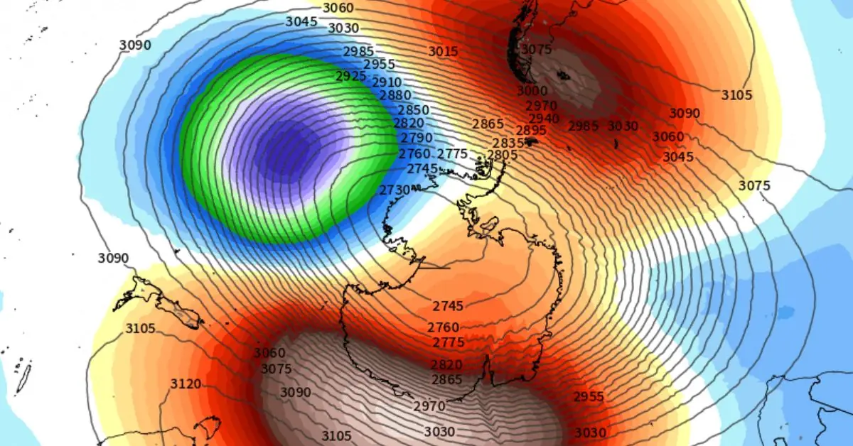
Rare Sudden Stratospheric Warming event detected over Antarctica
A rare Sudden Stratospheric Warming (SSW) event has been detected in the stratosphere above the Antarctic region over the past week. Forecast models predict it will start to filter down through the…
watchers.news
W
look on the bright side… at least you’ve got easy access to a sauna
Downeastnc
Member
3k nam pretty interesting for tomorrow the outflow from the dying derecho blows up and crosses parts of NC and Virginia..
Shaggy
Member
84 over 77 at 7:20 in the morning heat index of 94 this Summer sucks
WXinCanton
Member
Damn, I didn't get jack IMBY
Shaggy
Member

All sides of me got a good bit but only .07" IMBY. I'm still milking that 3.22" from last week so I can't complain. It was enough to green the grass but not enough to make it grow too much.Damn, I didn't get jack IMBY
Thick clouds here as we get ready to approach high noon. Not sure if its debri clouds from out west last night or sign some may luck up in a few hours. Lee side trough development
BHS1975
Member
It looks like RDU’s highest today may end up “only” at 97 (high through 4:30PM) though it could sneak up to 98. Comparing to FAY and Winston, that’s not out of line as they have been similar today.
Maybe it's only hotter at RDU when the soil is bone dry.
Sent from my iPhone using Tapatalk
Maybe it's only hotter at RDU when the soil is bone dry.
Yeah, I’ve also been wondering if the flash drought was contributing more to heat at RDU vs FAY and other nearby locations. OTOH, just yesterday RDU was still 2 hotter than FAY.
That’s how it’s been for me until yesterday. All around me all the time.Damn, I didn't get jack IMBY
So back
JHS
Member
This wet pattern we were supposed to go into is slowly slipping away. We have gone from 4+ inches to under 2 now on the GFS over much of upstate SC. We probably will not cool off as much as expected either.
You should have expected that. Cut the wet periods in half, when you see forecast highs in the low 80s, add 7 degrees, extend heat waves by 3 days, rinse and repeat.This wet pattern we were supposed to go into is slowly slipping away. We have gone from 4+ inches to under 2 now on the GFS over much of upstate SC. We probably will not cool off as much as expected either.
Why would you put any faith in the GFS, whether one run or a a few. I have heard it called the gonna f,n suck model for so long now. I too get drawn in to the runs where it lays down a good amount of rain but then get put back to reality the next run.This wet pattern we were supposed to go into is slowly slipping away. We have gone from 4+ inches to under 2 now on the GFS over much of upstate SC. We probably will not cool off as much as expected either.
.png")
Quick hitter. Dumping 
I’m moving (locally) this weekend, so of course the drought would end then. Great timing! I could use a dry Saturday! 
Shaggy
Member
06Z 3k drops 7.7 inches over the cape fear region. Hope it's right
Shaggy
Member
Storms firing already
Heat, frost, wind advisory capital here but we suck at getting snow or rain
Shaggy
Member
Gonna get missed by the big totals again but I'll take every drop I can getHeat, frost, wind advisory capital here but we suck at getting snow or rain

Shaggy
Member
Once again I was on the edge of the bigger totals but a quick unexpected .20 is a win.

These dry models
.png")