Idk if that big cutter right before this is going to help our causeGotta time it right but this is a big change on the gfs for late next week MUCH colder
Sent from my iPhone using Tapatalk
-
Hello, please take a minute to check out our awesome content, contributed by the wonderful members of our community. We hope you'll add your own thoughts and opinions by making a free account!
You are using an out of date browser. It may not display this or other websites correctly.
You should upgrade or use an alternative browser.
You should upgrade or use an alternative browser.

Storm5
Member
The blocking trying to develop is nice to see though. Pac is a mess and will be a mess until we get past phase 5.
View attachment 9318
Yep , plenty of cold in Canada
 as well . Funny part is even with the pacific being a mess with the press north of the Great Lakes the mid south could time an overrunning event if the stars lined up correctly .
 But yeah the pacific is a hot mess
Sent from my iPhone using Tapatalk
When you say the pacific is a mess what exactly do you mean? Too much activity due to the location of the MJO?The blocking trying to develop is nice to see though. Pac is a mess and will be a mess until we get past phase 5.
View attachment 9318
B
Brick Tamland
Guest
I think we could have a shot at another winter storm the first week of the New Year.
NBAcentel
Member
7-10 days after thun derstorms, you get sleet and zr lol, anyways looks like models tryna latch on to maybe some overrunning
derstorms, you get sleet and zr lol, anyways looks like models tryna latch on to maybe some overrunningtonysc
Member
It’s been a while. We’re actually overdue for an event like that. Columbia is only an hour from my house so I may just have to ride to Rush’s for a cheeseburger and check out the snow
You just had to mention Rush's cheeseburgers didn't you?
tonysc
Member
Yup, 1973 and 2010
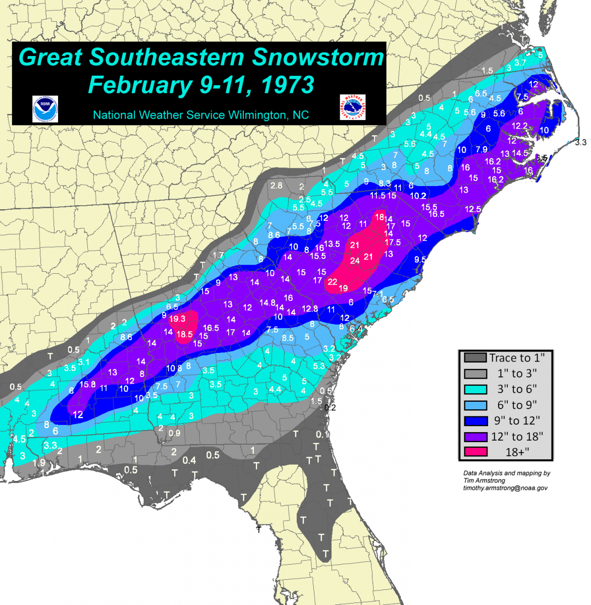
My favorite snowstorm of all time. I was living in Greenwood, SC. 12-14 inches I got.
Kylo
Member
When you say the pacific is a mess what exactly do you mean? Too much activity due to the location of the MJO?
Pretty much...phases 3-5 have convection to far west to promote Aleutian low. Why we love modoki so much and dislike east based nino's so much.
https://www.climate.gov/sites/default/files/styles/inline_all/public/MJOfig1.png?itok=v0KBslE6
Hmmm. This map is showing 7-8" for the Greenwood area.My favorite snowstorm of all time. I was living in Greenwood, SC. 12-14 inches I got.
SnowNiner
Member
That's different...not so crappy. Let's go!! lol. Probably a bit early.

Kylo
Member
GEFS says -NAO for the win.

tonysc
Member
Hmmm. This map is showing 7-8" for the Greenwood area.
Hmmm all you want too, that's what I got.
It's going to block all that mild Pacific air from leaving. That warm pool in the GOA is not doing its job at all. #warmpoolfakenewsfraud
That upper disurbance may bring some light rain showers on Christmas Eve morning (timing may change) I doubt it will be cold enough for any frozen precip. areas south of TN. The northern fringes of TN into KY may get some light ice pellets/freezing drizzle/light freezing rain. The images are from the FV3, we might as well quit using the GFS.


Last edited:
SnowNiner
Member
It's going to block all that mild Pacific air from leaving. That warm pool in the GOA is not doing its job at all. #warmpoolfakenewsfraud
Nah, it looks cool. Not saying I believe it but verbatim it looks like a step in the right direction. Need the Aleutian low to keep retrograding west to pump the western ridge to really get in the game...but hey, it'd be really nice if we get this look early January instead of mid/late. Probably a bit too early though.

That's realistic, I've been talking about those wrap around snows over the past days. There could be some isolated areas across TN/into KY/far northern GA receiving some light accumulations. The NW facing slopes will no doubt get good accumulating snowfall.Better question is what is the NAM smoking?

The anomalies aren't bad. Not snowy weather, but no 70s at least. We do need that Aleutian Low to retrograde, as you said. Not going to get much of a flow out of the Arctic with continual storms in the GOA.Nah, it looks cool. Not saying I believe it but verbatim it looks like a step in the right direction. Need the Aleutian low to keep retrograding west to pump the western ridge to really get in the game...but hey, it'd be really nice if we get this look early January instead of mid/late. Probably a bit too early though.
View attachment 9323
12z Euro still has the weak disturbance, Christmas Eve into Christmas day. Weak wedge, only if that high was a bit further south and east, and if it had a stronger mb, of course the wedge would be stronger. Still, something to watch.


Preach!!Hmmm all you want too, that's what I got.
18z GFS has that weak disturbance, some may luck out and get some light snow/sleet early, early Christmas Eve morning. I hope it trends colder, I hate to miss out on some light snow/sleet on Christmas Eve. That's a win!


January ( see new avatar)
Storm5
Member
Even though the pacific is a hot mess and the PNA sucks I’d take this look pretty much everyday during the winter

Sent from my iPhone using Tapatalk

Sent from my iPhone using Tapatalk
RollTide18
Member
Remember when we were supposed to torch on Christmas and New Years?


NBAcentel
Member
Lol at the gfs, has snow for me the day before new years, could there be a overruning event with a horrid dumpster juice pattern ?
Jessy89
Member

With that strong of a high on the playing field. This can trend a lot colder
Sent from my iPhone using Tapatalk
What’s good about it?Do not toss the 18Z GFS. Repeating, do not toss the 18Z GFS.
Holy cow. Like very much!
With that strong of a high on the playing field. This can trend a lot colder
Sent from my iPhone using Tapatalk
Storm5
Member
With that strong of a high on the playing field. This can trend a lot colder
Sent from my iPhone using Tapatalk
Too bad it’s so far out . Next run we could be right back in the 60s
Sent from my iPhone using Tapatalk
NBAcentel
Member
Models have been showing this sorta set up for the past 2 days now, just been inconsistent temperatures
NBAcentel
Member
Gfs has snow for me while fv3 has sleet and zr on same day before new years, hmmm they did the same thing with that dec 8-9 storm, what are the chances ?
Kind of odd, is that ridging in Siberia? Surely not.
packfan98
Moderator
Ensembles are starting to make some noise between 12/29 - 1/3 for the I-40 corridor north in NC. Let’s see if the signal grows over the next few days. Regardless, looks like by next week this time we should be seeing more activity on the models as we step our way to a more favorable pattern.
Wave looks nice and flat. I’m not like most guys. I love a little flat chested wave. Especially one with LEGS!
With that strong of a high on the playing field. This can trend a lot colder
Sent from my iPhone using Tapatalk
Kylo
Member
Bulk of that in NW NC is from the NY’s potential. How about another 87 January repeat, which started off with big NY’s event for western NC.

I lovee BIG busts! That’s what this map has written all over it!Wave looks nice and flat. I’m not like most guys. I love a little flat chested wave. Especially one with LEGS!
RollTide18
Member
I lovee BIG busts! That’s what this map has written all over it!
Enjoy your 33 and rain storm brother!
Well playedI lovee BIG busts! That’s what this map has written all over it!
Jessy89
Member
I think that even a day after this past storm. The models showed last week of December to possibly early January. As a potential time frame to watch. And I still think that remains the case. Doesn’t mean we will get a storm but the potential is at least there. Has been off and on for a while
Sent from my iPhone using Tapatalk
Sent from my iPhone using Tapatalk
ATLwxfan
Member
Too bad it’s so far out . Next run we could be right back in the 60s
Sent from my iPhone using Tapatalk
Sadly this is the best look we got south of God’s country. Right now our hopes hinge on the alleged SSW.
Sent from my iPhone using Tapatalk