dsaur
Member
A little cad induced ice a week out oddly doesn't seem too outrageous in early Dec, lol. I imagine climo says it's happened before..Larry??
If the 12z GFS 1040 HP verified you would more than likely get your sleet!A little cad induced ice a week out oddly doesn't seem too outrageous in early Dec, lol. I imagine climo says it's happened before..Larry??

GS, I've seen sleet in early Dec before, just not more than a few minutes before the waa moved in. This looks like a strong enough cad to push some in to Ala. If it's still there two days out, I'll start sanding the rust off the runners, lol. I'd like to hear Larry say climo agrees, then if it's two days out, I might get the studded snow tires out, so I can get out to the state road, lol.If the 12z GFS 1040 HP verified you would more than likely get your sleet!
I found an old post from Larry on December SN/IP. See below.GS, I've seen sleet in early Dec before, just not more that a few minutes before the waa moved in. This looks like a strong enough cad to push some in to Ala. If it's still there two days out, I'll start sanding the rust off the runners, lol. I'd like to hear Larry say climo agrees, then if it's two days out, I might get the studded snow tires out, so I can get out to the state road, lol.

Thanks for uploading.Low south


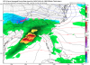
Also after seeing this run. I pumped up about this.View attachment 7824
Things kinda mess up after this time frame. I would think this thing would produce just as good as it moves east.