Dang, only 6-10 even in the NW NC mtns.GEFS is down a good bit on totals

-
Hello, please take a minute to check out our awesome content, contributed by the wonderful members of our community. We hope you'll add your own thoughts and opinions by making a free account!
You are using an out of date browser. It may not display this or other websites correctly.
You should upgrade or use an alternative browser.
You should upgrade or use an alternative browser.
Wintry Dec 8-10th Winter Storm
- Thread starter SimeonNC
- Start date
GeorgiaGirl
Member
Honestly the FV3 probably is depicting the CAD a bit better than the old GFS. I want to have what FFC is smoking if they really believe what they had put out, but I do think there's a chance there's ice from the NE ATL suburbs and up.
Ouch that average dropped from like 10 inches to 2 inches in RDU. Maybe the NAM is not crazy after all.
Avalanche
Member
Dang, bullseye is down to 9. Yeah that went waayyy down.GEFS is down a good bit on totals
Snowflowxxl
Member
850s colder on the Euro thru 48. Low is a tick south also
WXinCanton
Member
Crap my bad. I went to far out earlier so it included some melting. Here is the highest totals for the latest GEFS

Euro please restore faith and hope to the boards850s colder on the Euro thru 48. Low is a tick south also
Jessy89
Member
Oh yes I’ll be happy with 2inches2 inches is plenty for the kids to enjoy
Don’t look at it. I’m tellin ya!
It's all about perspective. 2 inches in early December is a win for everyone honestly.Oh yes I’ll be happy with 2inches
Snownut
Member
It has been an I85 special pretty much from the get go.If anything, this thing has trended to a tighter gradient trying to set up along 85. I need it to wiggle that line a tick south which it will do every now and again especially with a cold wedge in place
Sent from my SM-G955U using Tapatalk
Snowflowxxl
Member
HP is down 2 from yesterdays 12z run at 72.
Jessy89
Member
Yes it is but what’s bad is the models still flip floppingIt's all about perspective. 2 inches in early December is a win for everyone honestly.
Snownut
Member
And that is probably the more realistic totalsGEFS is down a good bit on totals
Sent from my SM-G955U using Tapatalk
Snowflowxxl
Member
Euro should be a solid hit

But not for ATLEuro should be a solid hit
Snowflowxxl
Member
I think it will be very closeBut not for ATL
Blue_Ridge_Escarpment
Member
That’s snow depth on Wednesday morning. So it’s probably higher than that.GEFS is down a good bit on totals
Brandon10
Member
Can't understand why 850s are prime for snow all the way to the coast of NC but it shows rain....daggum column
yeah the question for ATL will be transition in later frames and tailing ULLBut not for ATL

GeorgiaGirl
Member
Euro's depiction is probably about what I'd expect ice wise for NE GA. It could get closer but that seems like a realistic run to me.
Looks pretty good for NC as well.
Looks pretty good for NC as well.
Yellow Snow
Member
Peachtree City just held a briefing on the weekend winter weather threat. Here's the summary slide:
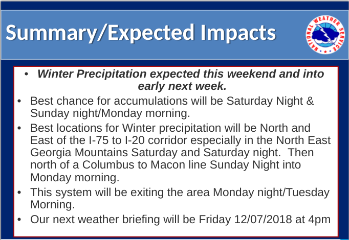
You can view the full presentation here -
https://www.weather.gov/media/ffc/Briefings/Dec06_Briefing.pptx
You can view the full presentation here -
https://www.weather.gov/media/ffc/Briefings/Dec06_Briefing.pptx
NBAcentel
Member
Man should I trust that heavy thump of snow and graupel in the piedmont of nc or nah ? So much disagreement on that with models
I don't think there would be melting on Tuesday though ?That’s snow depth on Wednesday morning. So it’s probably higher than that.
Kylo
Member
Euro
Probably a lot of sleet towards RDU
Probably a lot of sleet towards RDU
So if this map includes sleet why does it say Total Snowfall Accumulation ? Seems misleading to me.
Storm5
Member


Sent from my iPhone using Tapatalk
NorthGaWinter4
Member
Euro looks like it’s lights out here
Can't understand why 850s are prime for snow all the way to the coast of NC but it shows rain....daggum column
Because there are many things that go into getting snow than just <0C at 850mb.
Ewwww.... barely advisory stuff here b/c will be tons of mixing and my guess is it will continue to shift NW. Oh well I was never really in the game but was hoping for the best...
NorthGaWinter4
Member
Can you show the ice in NEGA


Sent from my iPhone using Tapatalk
Man that transition line rockets NW....
Sent from my iPhone using Tapatalk
Euro still looks pretty good for the initial front end thump, but I think it's more likely than not that it will be mostly sleet rather than snow. I don't think RDU has much of a chance to squeeze out more than an inch or two of snow/sleet mix, and even that may be generous. We'll see.
whatalife
Moderator
Man that transition line rockets NW....
Give it some time and it will rocket even further NW...
Sent from my iPhone using Tapatalk
Storm5
Member
Man that transition line rockets NW....
Yeah it’s front end or bust
Sent from my iPhone using Tapatalk
and it will likely set up shop further nw than the model guidance suggests, like it always does.Man that transition line rockets NW....
B
Brick Tamland
Guest
Big hit on the Euro for NC. GFS backed off a bit, but the globals have held serve so far compared to yesterday.
whatalife
Moderator
Yeah it’s front end or bust
Sent from my iPhone using Tapatalk
Some people are about to be sorely disappointed.
Sent from my iPhone using Tapatalk