B
Brick Tamland
Guest
So, it's one bad run of the NAM, one not as good run of the GFS versus great runs of the FV3, Canadian, and UK so far today.
My apologies, was just trying to kill time between runs.Lots of banter..... just a friendly reminder please help us keep this thread clean/crisp and on topic. Thanks
Yeah but I just don't see it being snow ? Seems like more of an icing scenario ?They are the national weather service and Brad P. Even said himself models aren’t handling the cad well enough. They may be on to something
I expect a more amped ull as we get closer. We shall see how that changes things.So, it's one bad run of the NAM, one not as good run of the GFS versus great runs of the FV3, Canadian, and UK so far today.
Yes. Based on the Ukie snow map, it looked pretty steady to me. I’m expecting a slight nw shift on the Euro but pretty similar to its last run overallDoesn't the UKMET usually indicate how the Euro will go?
If that's anything we can bet, the Euro will be similar when it runs to that. I'm backing away from the edge once more.UKMET way better for NE GA
I think so.Doesn't the UKMET usually indicate how the Euro will go?
I get it and honestly again it's not a huge deal but unfortunately it usually just snowballs and next thing you know it's like people just carrying on a conversation in here, and thanks.My apologies, was just trying to kill time between runs.
Verbatim the FV3 starts this off in RDU as heavy snow at hour 66.


If FFC is on to something, it looks like the adjacent NWS offices aren't seeing it yet...They are the national weather service and Brad P. Even said himself models aren’t handling the cad well enough. They may be on to something

Looks way further into GA than last run. It sounds crazy but last nights NAM could be very accurate with this storm when it’s all done. We’re ridinng from run to run and everything is all over the place North South East West this storm has shifted all over the place on these models with no consistency so honestly we may not know what happens until it happens. If u have had something from one of the model runs then u are in the game because of the inconsistency so far. My opinion
That is 4am sat morningIf FFC is on to something, it looks like the adjacent NWS offices aren't seeing it yet...
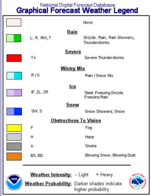
So according to that map, the light and dark purple are both ice. Does the darker shaded purple indicate heavier freezing rain ? I guess according to this map West GA is going to see some heavy freezing rain.If FFC is on to something, it looks like the adjacent NWS offices aren't seeing it yet...
Wouldn’t the upstate be seeing something to by 4amThat is 4am sat morning
Sent from my SM-G955U using Tapatalk
I know - my point is that the IP line magically ends at the borders of their CWA.That is 4am sat morning
Sent from my SM-G955U using Tapatalk
At least the surface low is lowerI agree....anything under that upper low will be light at best for sure. Anyone who sees anything under that ULL and its flurries...call it a big win...
") Get it into Fla, and us away from the heat, and the cad could do it's work better. Still time to adjust for more of Ga than Clayton Co.
Get it into Fla, and us away from the heat, and the cad could do it's work better. Still time to adjust for more of Ga than Clayton Co.Not sat morning no. Sunday morning yesWouldn’t the upstate be seeing something to by 4am
Oh sorry read that wrongNot sat morning no. Sunday morning yes
Sent from my SM-G955U using Tapatalk
If FFC is on to something, it looks like the adjacent NWS offices aren't seeing it yet...
No.Does any modeling even support this widespread ZR?
Sent from my iPhone using Tapatalk
My God I would hate to be in Charlotte. Talk about threading the needle !
Here's the color key:So according to that map, the light and dark purple are both ice. Does the darker shaded purple indicate heavier freezing rain ? I guess according to this map West GA is going to see some heavy freezing rain.
Yeah basically the way Tidbits determines what p-type is falling is pretty flawed and doesn't look at the entire column. So if an area is 33-34 at the surface and 850s are fairly close to 0C but above it it will show that as "snow" on the accumulation map even though it would be rain or at best sleet falling.
Not quite, DGZ is very dry. Probably mostly sleet.
Darker shades indicate higher probability. So according to them, West GA has a higher probability of seeing Freezing Rain than NE GA. Ok then........Here's the color key:
Until it is nothing, other than a rain sleet mix.Wow, that would be something.
Yep, Rain mixed with the occasional pinger. Folks are trying to read too much into it.They particularly state IP in that Georgia Graph so I assume they expect due to temps majority of Mix will be in the form of Sleet
You'd think so, but BMX isn't seeing it that way - just plain ol' rain in eastern AL according to them.Darker shades indicate higher probability. So according to them, West GA has a higher probability of seeing Freezing Rain than NE GA. Ok then........
This map shows Pickens County getting 6 inches. Downtown Greenville less then 2 inches...My God I would hate to be in Charlotte. Talk about threading the needle !


2 inches is plenty for the kids to enjoyThis map shows Pickens County getting 6 inches. Downtown Greenville less then 2 inches...

