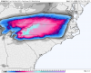
euro kuchera map shifted nw vs 00z.Big hit on the Euro for NC. GFS backed off a bit, but the globals have held serve so far compared to yesterday.
-
Hello, please take a minute to check out our awesome content, contributed by the wonderful members of our community. We hope you'll add your own thoughts and opinions by making a free account!
You are using an out of date browser. It may not display this or other websites correctly.
You should upgrade or use an alternative browser.
You should upgrade or use an alternative browser.
Wintry Dec 8-10th Winter Storm
- Thread starter SimeonNC
- Start date
TigerSnow
Member
I've never seen so many debbie downers or negativity before. It amazes me. It's weather it will change. Fact is we do not know what will happen right up until game time almost. We have the players in place and now we just have to see how it all shakes out. For early December it is about all we can ask for.
RollTide18
Member
Ride the NAM till it has a fiery crash
Kylo
Member
Man that transition line rockets NW....
It moves NW because the main band is NW of us, if we kept heavy banding it would probably stay frozen. Front end thump, dry slot works too. If Raleigh gets 2" of sleet/snow I would call that a major victory for December. Heck that would be the 2nd biggest snow we had since 2015, almost 4 years ago.


The warm nose can be above/below 850 hPaCan't understand why 850s are prime for snow all the way to the coast of NC but it shows rain....daggum column
Still liking an inch for Raleigh, followed by freezing rain and then rain. Charlotte could do a bit better...maybe 3” before the changeover. GSO looks good for around 6-7” and will probably stay all frozen. The corridor from roughly Boone to Asheville should be the sweet spot with 12-15”.
I'd agree, but I don't see too much of a ZR threat in Raleigh, surface temps are just too marginal. I think GSO may get several of those inches in sleet tooStill liking an inch for Raleigh, followed by freezing rain and then rain. Charlotte could do a bit better...maybe 3” before the changeover. GSO looks good for around 6-7” and will probably stay all frozen. The corridor from roughly Boone to Asheville should be the sweet spot with 12-15”.
Sandbar
Member
Placement of the high is crucial
Yup....Unless something changes I wholeheartedly agree but were are now at that point where things are more apt to trend bad than good in my neck of the woods. Very little room for error has reared its ugly head.....with marginal cold source to work with everything has to be placed perfectly and move perfectly for the those of us on the fringes.Some people are about to be sorely disappointed.
Sent from my iPhone using Tapatalk
Yeah, I don't expect much ZR here, unless we really start to see a reversal on the CAD situation in the next 24-36 hours. Very discouraging to see these 1040 highs become 1030 highs as we near game time. But it's typical, I guess.I'd agree, but I don't see too much of a ZR threat in Raleigh, surface temps are just too marginal. I think GSO may get several of those inches in sleet too
whatalife
Moderator
Placement of the high is crucial
Yup....Unless something changes I wholeheartedly agree but were are now at that point where things are more apt to trend bad than good in my neck of the woods. Very little room for error has reared its ugly head.....with marginal cold source to work with everything has to be placed perfectly and move perfectly for the those of us on the fringes.
Agreed and I doubt we see a 1041 like last nights nam run...
Sent from my iPhone using Tapatalk
Kylo
Member
Some subtle or not so subtle changes in the atlantic blocking. You can see why the backside stuff isn't as good, though still time for that change. Our 50/50 lifts NE but another lobe rotates down, so now there is an alley to escape further east.
.gif")
with rah likely to beef up their wording this afternoon, it reminds me of jan 2017 when they were calling for big totals even when the nam was firing warning shots on ptypes. i think their low end total was 4-5" or something while the nam showed rain and sleet.Yeah, I don't expect much ZR here, unless we really start to see a reversal on the CAD situation in the next 24-36 hours. Very discouraging to see these 1040 highs become 1030 highs as we near game time. But it's typical, I guess.
B
Brick Tamland
Guest
Euro showing 7 to 10 for Wake. Really, not sure why folks even come here to discuss the models if they already make up their minds up they are wrong and what will happen.I've never seen so many debbie downers or negativity before. It amazes me. It's weather it will change. Fact is we do not know what will happen right up until game time almost. We have the players in place and now we just have to see how it all shakes out. For early December it is about all we can ask for.
Storm5
Member
Euro showing 7 to 10 for Wake. Really, not sure why folks even come here to discuss the models if they already make up their minds up they are wrong and what will happen.
Don’t listen to them . Enjoy your snow man . Jealousy brings out negative comments
Sent from my iPhone using Tapatalk
I've never seen so many debbie downers or negativity before. It amazes me. It's weather it will change. Fact is we do not know what will happen right up until game time almost. We have the players in place and now we just have to see how it all shakes out. For early December it is about all we can ask for.
Uh oh, the transition is occurring. The nowcast time phase is about to commence.
Really not sure why some even come on here to hug snowfall maps when they know they're going to be wrong.
SimeonNC
Member
I feel like CLT points north will stay all frozen, I'm anticipating the surface temps being below freezing for most of the event . It won't be all snow but I doubt that much of it will be rain here.Still liking an inch for Raleigh, followed by freezing rain and then rain. Charlotte could do a bit better...maybe 3” before the changeover. GSO looks good for around 6-7” and will probably stay all frozen. The corridor from roughly Boone to Asheville should be the sweet spot with 12-15”.
Sent from my Z983 using Tapatalk
As long as it's FROZEN...
Kylo
Member
Yeah, if people in Raleigh are expecting 6" that isn't happening. But, front end 1-2" with some sleet then transition to rain is in the realm of possibilities. I wouldn't put money on that though.Really not sure why some even come on here to hug snowfall maps when they know they're going to be wrong.
You got one of them purdy up close snowfall total maps too??


Sent from my iPhone using Tapatalk


SimeonNC
Member
Even if the high ends up being weaker, CAD probably will overperform like it typically does. I guess my cell would be 3-5" from the front end thump with higher or lower totals as you go north or south through the metro. Then I can see a lot of the area going to IP or ZR.
Sent from my Z983 using Tapatalk
Sent from my Z983 using Tapatalk
NBAcentel
Member
Yeah I agree with you simeon, might be some major sleet accums CLT-north
Sandbar
Member
Yeah, if people in Raleigh are expecting 6" that isn't happening. But, front end 1-2" with some sleet then transition to rain is in the realm of possibilities. I wouldn't put money on that though.
Well except for the 10" at Brick's house! I hope that pretty map verifies for the guy!
Snowflowxxl
Member
Even if its just a front end thump for you guys, thats still great. We live in the southeast, we probably shouldnt be too picky about what kind of snow we get!
NorthGaWinter4
Member
How much ice did the euro show for NEGA?
Well with all the 12z Models the Midlands of SC is all the rain the whole event. Dont be surprise if models continue to shift NW and Carolinas may have a better chance to see severe weather than wintry wx.
B
Brick Tamland
Guest
Really not sure why some even come on here to hug snowfall maps when they know they're going to be wrong.
Show me the scientific data that we have at this moment to say it is wrong. Not just because climatology and what has happened before. That's my point. If you think it's wrong just because of the past and pessimism, then why do you even bother to check out what the models show?
Jessy89
Member
Isn’t this about the time models shift north? Then back south right before the event?
Kylo
Member
Just posting this of the FV. Been a lot of talk that's it's been solid. This looks like snow mid-day Sunday. Like to post this stuff so we can come back and look to see how it did.

I think we (Raleigh) has a chance to stay frozen through mid-day Sunday. FV is much quicker bringing in precip than Euro.


I think we (Raleigh) has a chance to stay frozen through mid-day Sunday. FV is much quicker bringing in precip than Euro.
AS long as it's FROZEN, I'm Good...
Anyone got RPM graphics?
MichaelJ
Member
12Z GEFS for KINT, went down about 4 inches on the mean

If you had never seen a beehive before and I told you that if you kick it over gold coins would fall out of the sky, you would kick it over. Bees would sting your butt back to the stone age, and you would still be broke. I can't tell you scientifically that the next time you kick over a beehive that bees won't sting you. But I can tell you that you probably won't kick over any more beehives. Forecasting is about experience and interpretation as much or more as it is about looking through snow googles at pink colors on a dumb map.Show me the scientific data that we have at this moment to say it is wrong. Not just because climatology and what has happened before. That's my point. If you think it's wrong just because of the past and pessimism, then why do you even bother to check out what the models show?
Dang man, went from being positive to negative. Atleast there is a chance to see some flurries as it pulls away. I'd count that as a positive for early December. Isn't even Winter yet. I know that doesn't make any of us feel any better down here in SC, but it's all we got.Well with all the 12z Models the Midlands of SC is all the rain the whole event. Dont be surprise if models continue to shift NW and Carolinas may have a better chance to see severe weather than wintry wx.
Storm5
Member
Damn , please stay on topic . If you wanna discuss why people come here go to banter
Sent from my iPhone using Tapatalk
Sent from my iPhone using Tapatalk
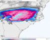
with sleet (smoother one), without sleet(blockier one)You got one of them purdy up close snowfall total maps too??
Attachments
Storm5
Member
For you met

Sent from my iPhone using Tapatalk

Sent from my iPhone using Tapatalk
Kylo
Member
12Z GEFS for KINT, went down about 4 inches on the mean
One reason is QPF went down almost 0.5". Still 1.5" QPF on a mean ain't no slouch.
Sandbar
Member
Show me the scientific data that we have at this moment to say it is wrong. Not just because climatology and what has happened before. That's my point. If you think it's wrong just because of the past and pessimism, then why do you even bother to check out what the models show?
Why don't you "explain" to everybody what these models are seeing that will lead to all this snow for Wake County? You have sparked my curiosity. I have seen the pretty pictures too.....In all seriousness lets here your thoughts with a bit more of a meteorological perspective