Yeh no way Columbia gets up to 2 inches of snow with a quarter inch of ice. Way to aggressive.. sheesh.View attachment 8668 A ray of sunshine!? I’m assuming this map was made before the 12z runs!
-
Hello, please take a minute to check out our awesome content, contributed by the wonderful members of our community. We hope you'll add your own thoughts and opinions by making a free account!
You are using an out of date browser. It may not display this or other websites correctly.
You should upgrade or use an alternative browser.
You should upgrade or use an alternative browser.
Wintry Dec 8-10th Winter Storm
- Thread starter SimeonNC
- Start date
snowlover91
Member
18z NAM is running, let's see if this one pushes us over the cliff or keeps hope alive...
At this point, I don't really understand what is inconsistent with the models? I mean, there is a little wobbling. But for places in the triad and mountains and even into charlotte, it's been very consistent it seems. Has showed over 6 inches of frozen whatever for charlotte for like 3-4 days now.
B
Brick Tamland
Guest
Don Sutherland had an interesting post at the other board.
IMO, based on the forecast 500 mb pattern, its forecast evolution, and the very good run-to-run continuity of the guidance, one should have above average confidence in the modeled snows. While some changes from the current guidance are likely, those changes should be smaller than is typically the case. One isn't dealing with a storm in which there's a significant probability that it could track much farther north and west than what is currently shown. One also isn't dealing with a storm where there is such great uncertainty about the thermal profile or a marginal air mass where things could rapidly "fall apart" so to speak. This is likely to be a special storm for the Lower Mid-Atlantic and parts of the Southeast. It could be a memorable one for parts of the region.
IMO, based on the forecast 500 mb pattern, its forecast evolution, and the very good run-to-run continuity of the guidance, one should have above average confidence in the modeled snows. While some changes from the current guidance are likely, those changes should be smaller than is typically the case. One isn't dealing with a storm in which there's a significant probability that it could track much farther north and west than what is currently shown. One also isn't dealing with a storm where there is such great uncertainty about the thermal profile or a marginal air mass where things could rapidly "fall apart" so to speak. This is likely to be a special storm for the Lower Mid-Atlantic and parts of the Southeast. It could be a memorable one for parts of the region.
Avalanche
Member
The only thing ive noticed is the convection along the gulf choking our flow a little, so maybe a slight reduction in total liquid. But yeah, charlotte towards boone has been written in stone for daya now.At this point, I don't really understand what is inconsistent with the models? I mean, there is a little wobbling. But for places in the triad and mountains and even into charlotte, it's been very consistent it seems. Has showed over 6 inches of frozen whatever for charlotte for like 3-4 days now.
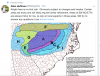
At first, I thought that accumulation map from AshevilleWx was a watch, warning, advisory product. It's a nice map, but it is over done for some, especially west of ATL and eastern TN.
Jon
Member
At this point, I don't really understand what is inconsistent with the models? I mean, there is a little wobbling. But for places in the triad and mountains and even into charlotte, it's been very consistent it seems. Has showed over 6 inches of frozen whatever for charlotte for like 3-4 days now.
Yep. It’s IMBY stuff...the Euro has been pretty solid.
Sent from my iPhone using Tapatalk
RollTide18
Member
At first, I thought that accumulation map from AshevilleWx was a watch, warning, advisory product. It's a nice map, but it is over done for some, especially west of ATL and eastern TN.
They’re probably counting in the trailing wave as well
Storm5
Member
Almost 10 at the house. Lol
Sent from my SM-G955U using Tapatalk
Stay at work , it will verify if you go to the house it won’t
Sent from my iPhone using Tapatalk
packfan98
Moderator
DamnHere we go with Allan's thoughts:
Sent from my SM-G955U using Tapatalk
Fountainguy97
Member
NAM continues our weakening HP trend.
Shocker.

Shocker.
5-9 inches? Wow.Here we go with Allan's thoughts:
DadOfJax
Member
Here we go with Allan's thoughts:
Thats laughable outside of western NC
RollTide18
Member
Time for the NAM to break my heart even more
Avalanche
Member
I feel like all of our benchmarks will have to be right on que to get those totals, and i darn sure hope they are!!5-9 inches? Wow.
Dang Allan, that's awfully aggressive for places in the southern areas.. Sheesh. Section G is questionable.Here we go with Allan's thoughts:
I can appreciate that attention to detail over southern Greenville county. Nicely done Pack
Jessy89
Member
Can a 1035HP get the job done?
Fountainguy97
Member
Can a 1035HP get the job done?
No. Maybe in January with a much colder air supply. But not with what we have to work with.
Showmeyourtds
Member
Can a 1035HP get the job done?
I suppose it would depend on how far south it pushes. Certainly wouldn't want to squarsh ($1 to Roy D Mercer) the moisture.
B
Brick Tamland
Guest
That is awesome. That would be a major storm for most of NC.Here we go with Allan's thoughts:
B
Brick Tamland
Guest
I have read others say look at the globals regarding the HP and the NAM regarding cad.
Snowflowxxl
Member
NAM looks more defined this time out to 30 a maybe a touch warmer. splitting hairs
ForsythSnow
Moderator
1037 moving in faster. Should be a better run.
He has a cold biasDamn
Sent from my SM-G955U using Tapatalk
Sent from my SM-G950U using Tapatalk
Allan is always very bullish.
I can't wait till we get past the weakening trends with the high pressure.
I can't wait till we get past the weakening trends with the high pressure.
Snowflowxxl
Member
Yep CAD already building in better at 36 now and low looks south. Id bet on improvements down the line.
GeorgiaGirl
Member
Yeah I don't think you can just ignore the NAM entirely here, the globals have issues depicting CAD, except hopefully, the FV3 might be better than the old GFS with handling it (something we'll figure out this winter).
The HP might be too strong though.
The HP might be too strong though.
cut those totals in half east of the mtns and it would still be too highAllan is always very bullish.
I can't wait till we get past the weakening trends with the high pressure.
850 mb temps colder in NC this run
Webberweather53
Meteorologist
The last half of your post is pretty much what folks are talking about....
There doesn’t have to be a “big warm nose” for sleet, as I’m certain you know. In some gfs soundings yesterday they were definitely sleet. It just doesn’t take much...the soundings aren’t exactly spectacular and cold enough at all levels to rule out sleet....I’d have to have it a lot colder, like last year for our 6-10”+ storm we had.
Sent from my iPhone using Tapatalk
Yeah the models are usually piss-poor in setups like this with depicting a narrower corridor of sleet than what actually verifies. We may see a sharper rain-snow line on the back-end of the storm as cold air advection aloft plus the ULL attempt to scour out the CAD but there's a good part of this storm where it looks like ice pellets could be an issue, I think even more so in Charlotte obviously vs RDU.
DPs look lower on the NAM. Should be a good run for those in the CAD region.
Snowflowxxl
Member
This run should maybe moderate the panic among some NC posters I would think
Oh I agree, it's a super-marginal setup for the RDU corridor, I'm just saying that in the end it may end up being more of a rain or snow situation with only a narrow corridor of sleet (which Wake County is obviously a front runner to still be in potentially). Just my thoughts based on typical ptype distribution with these sort of setups - but I could be wrong and it'll certainly be interesting to see how wide the sleet zone ends up being.The last half of your post is pretty much what folks are talking about....
There doesn’t have to be a “big warm nose” for sleet, as I’m certain you know. In some gfs soundings yesterday they were definitely sleet. It just doesn’t take much...the soundings aren’t exactly spectacular and cold enough at all levels to rule out sleet....I’d have to have it a lot colder, like last year for our 6-10”+ storm we had.
Sent from my iPhone using Tapatalk
RollTide18
Member
Closed off at 500mb in Texas where it other runs it wasn’t, probably won’t mean much though

NAM has a 1038 mb high.
Snowflowxxl
Member
Coldest 850s have been in NC since 0z last night
Jessy89
Member
High maybe trending a touch stronger again