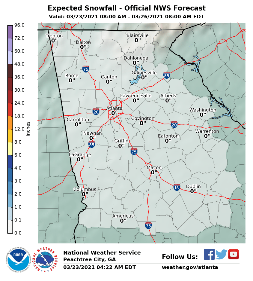
snowlover91
Member
And? Even a couple of inches of snow mixed with ice is a big deal.This is the actual snowfall guys.
So rain to ice/ sleet then to snow? I just want to see snow flakes as well. This simulated radar has been steady.This is the 18z, 12km NAM simulated radar.![]()
And the cliff divers return
Sent from my SM-G955U using Tapatalk
How accurate would this be?This is the 18z, 12km NAM simulated radar.![]()
NoWow! Big turnaround for the NAM.
Do we believe this one?
That's because it's all IP/ZR lol! That's very dependent on how the CAD sets up thoughView attachment 8686 View attachment 8687
Because this is trending towards Ice and sleet for areas around hereThat map paints very little snow in upstate sc
Thank you for posting this!! I am excited for my token flakes.This is the 18z, 12km NAM simulated radar.![]()
I am looking forward to my snow showers Monday atleast. Im really just want to see some flakes!
Guess we need a generator instead of a sledBecause this is trending towards Ice and sleet for areas around here
View attachment 8688 So close for Memphis at 3k nam at 60 hours. I still think their will be a lot of surprise with this system. Amazing how much uncertainty going on with the models.
The NW half, definitely. SE half is all IP/ZR. Here's the map valid at the same time without either View attachment 8682
So I'm not sure if anyone has noticed this, but there is an extended period on the NAM where ALL of WNC changes to sleet, even freezing rain in places, even in the mountains. Aside from a couple random Euro runs, I think this is the only model showing this right now. Wouldn't be surprised if it's on to something...
![]()
The good thing is it warms up in time to go to work Monday!Getting a foot of snow would be great, but you have a couple of inches of snow mixed with sleet and freezing rain, and it is going to be a mess.
They both look like DGEX maps!NAM looks like a FV3 map.
It's as simple as only accumulating the liquid equivalent of the snow if the categorical pytpe at that gridpoint is snow lol. The pre-calculated snow field that comes in the model must just assume anything frozen is snowThat looks great, would take that in a heartbeat. I assume this is some company tool you have to filter out IP/FRZN?
DarkKnight, do you think far northern Middle Tennessee could see a surprise out of this one? I’m talking like 20 minuets from the Kentucky boarder.View attachment 8688 So close for Memphis at 3k nam at 60 hours. I still think their will be a lot of surprise with this system. Amazing how much uncertainty going on with the models.
I’m on may way there now. I’ve been tempering the kids expectations and telling them we’ll be on the wrong side of the mountains.Winter storm watch Gatlinburg
Sent from my iPhone using Tapatalk