Drizzle Snizzle
Member
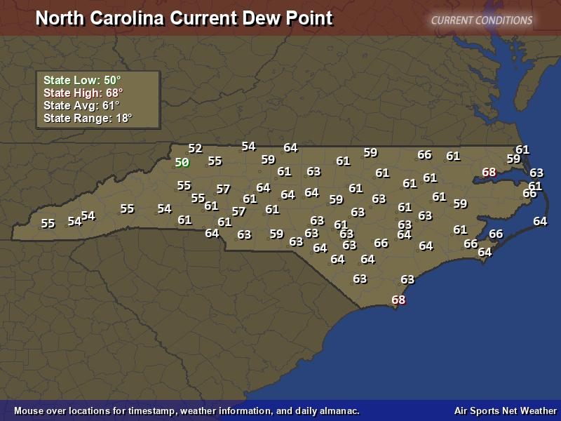
Pretty amazing to have such a high dewpoint so far away from any major body of water.I wasn't aware we relocated to the Gulf ?View attachment 136164
Pretty amazing to have such a high dewpoint so far away from any major body of water.I wasn't aware we relocated to the Gulf ?View attachment 136164
That’s a great comparison. If I remember also, that El Niño peaked during the late fall. I wonder if we might see the same thing with how early this one startedYes. You had a red hot GOM in an El Nino Year, and there was only one storm in the Gulf in August. The next one came in November. It's the same scenario I had in mind. "Prolonged rains resulting from a nearly stationary frontal boundary during September 16–22, 2009, caused severe flooding in northern Georgia." https://pubs.usgs.gov/of/2010/1230/pdf/ofr2010-1230.pdf
Pretty amazing to have such a high dewpoint so far away from any major body of water.
Wish it meant something.We now have a Late April sun angle !
and then back to 100 next weekendWell they cancelled our excessive heat warning for today... Progress
Gonna be flirting with 50s by Tuesday morning
Interesting picture choice ?View attachment 136169
Thank goodness!!!! 94 degrees right now on the field at Bank of America Stadium. Fortunately my seats will be in the shade in about 90 minutes.
We are getting close to the time of year when the dry weather starts to set in. Late Summer and Fall seems to be very dry in most years when there isnt a tropical system involved.1.1" for the day and 4.4" for August, easily the best start for any month this summer.
View attachment 136174
That’s not typically the case during El Niño though. We can expect to see the STJ get more involved as we get into fall.We are getting close to the time of year when the dry weather starts to set in. Late Summer and Fall seems to be very dry in most years when there isnt a tropical system involved.
Man I listened to that game and it sounded like it would just be miserableView attachment 136169
Thank goodness!!!! 94 degrees right now on the field at Bank of America Stadium. Fortunately my seats will be in the shade in about 90 minutes.
The 18z GFS is similar. This may be going to happen.600dm ridge over the OV is a hot setup for us east of the apps until it gets backdoored at the sfc or the mid level flow gets veered east/NEView attachment 136173
The 18z GFS is similar. This may be going to happen.
83/80 HI 95 at 755am in wilmingtonSo today looks a little on the warm side...mid 80' by 9 am with heat indexes pushing a 100 coming up.
| Humidity | 100% |
| Wind Speed | SW 6 mph |
| Barometer | 29.96 in |
| Dewpoint | 82°F (28°C) |
| Visibility | 7.00 mi |
| Heat Index | 95°F (35°C) |
| Last update | 13 Aug 8:45 am EDT |
Wilmington is 86 over 80 HI 101 at 9am. Just walked outside and it feels like it. Gonna hit the beach in a minute to bake away the morning.this is the best weather ever.......said no one. 82 dewpoint is stupid....
Fair
82°F
28°C
Humidity 100% Wind Speed SW 6 mph Barometer 29.96 in Dewpoint 82°F (28°C) Visibility 7.00 mi Heat Index 95°F (35°C) Last update 13 Aug 8:45 am EDT
It looks like a transient high that boosts highs a bit but then is weakened a good bit as the next trough tries to rebuild in the east. Pattern continues, but now the troughs are reaching a bit farther south. Either way, I'm going to enjoy mid-week as our dew points drop in to the mid-sixties resulting in more comfortable low temps per attached.Euro backed way off.
Sent from my iPhone using Tapatalk
The highest dewpoint I've ever experienced was at Myrtle Beach back in the eighties one July 4th weekend. I remember that the air temperature was 90 degrees at midnight on July 3rd and the dewpoint was around 85 degrees. Highs got over 100 degrees that weekend which made laying on the beach miserable to say the least. Cruising the strip that night was not much fun with the air bring that hot and humid. I was younger then and my definition of having a good time was much different than it is now.
| 13 | 10:05 | SW 10 G 16 | 10.00 | Partly Cloudy | SCT020 | 88 | 82 | 84% | NA | 109 | 29.98 | NA |
How much rain?On this day in 2004, Atlanta had a high of 76 and a low of 57 !
None. With a low of 57 it was pretty dry. You don't have temps in the 50s in the summer and rain. Atlanta got some of the dry air on the backside of Hurricane Charley.How much rain?

Back when we had real hurricanes. I miss those days.None. With a low of 57 it was pretty dry. You don't have temps in the 50s in the summer and rain. Atlanta got some of the dry air on the backside of Hurricane Charley.
Believe it or not, we are entering the peak of hurricane season.Back when we had real hurricanes. I miss those days.
Get out of here……Believe it or not, we are entering the peak of hurricane season.
